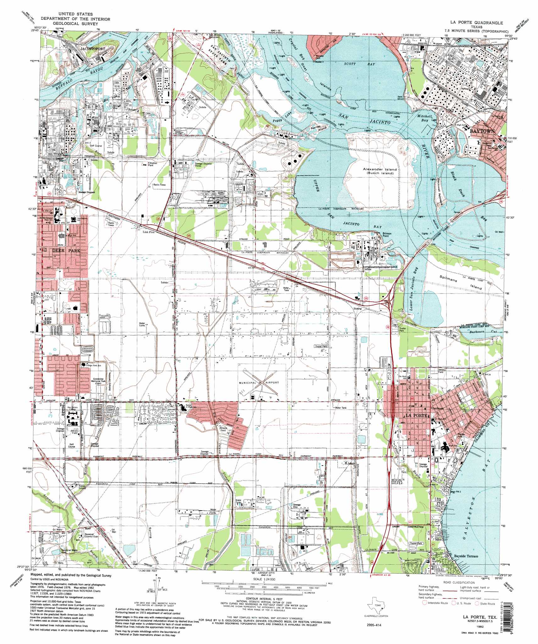
La Porte Topo Map Texas
To zoom in, hover over the map of La Porte
USGS Topo Quad 29095f1 - 1:24,000 scale
| Topo Map Name: | La Porte |
| USGS Topo Quad ID: | 29095f1 |
| Print Size: | ca. 21 1/4" wide x 27" high |
| Southeast Coordinates: | 29.625° N latitude / 95° W longitude |
| Map Center Coordinates: | 29.6875° N latitude / 95.0625° W longitude |
| U.S. State: | TX |
| Filename: | o29095f1.jpg |
| Download Map JPG Image: | La Porte topo map 1:24,000 scale |
| Map Type: | Topographic |
| Topo Series: | 7.5´ |
| Map Scale: | 1:24,000 |
| Source of Map Images: | United States Geological Survey (USGS) |
| Alternate Map Versions: |
La Porte TX 1916 Download PDF Buy paper map Laporte TX 1916 Download PDF Buy paper map La Porte TX 1955, updated 1957 Download PDF Buy paper map La Porte TX 1967, updated 1970 Download PDF Buy paper map La Porte TX 1982, updated 1983 Download PDF Buy paper map La Porte TX 1995, updated 1999 Download PDF Buy paper map La Porte TX 2010 Download PDF Buy paper map La Porte TX 2013 Download PDF Buy paper map La Porte TX 2016 Download PDF Buy paper map |
1:24,000 Topo Quads surrounding La Porte
Humble |
Harmaston |
Crosby |
Sheeks |
Moss Bluff |
Settegast |
Jacinto City |
Highlands |
Mont Belvieu |
Cove |
Park Place |
Pasadena |
La Porte |
Morgan Point |
Umbrella Point |
Pearland |
Friendswood |
League City |
Bacliff |
Smith Point |
Manvel |
Algoa |
Dickinson |
Texas City |
Port Bolivar |
> Back to 29095e1 at 1:100,000 scale
> Back to 29094a1 at 1:250,000 scale
> Back to U.S. Topo Maps home
La Porte topo map: Gazetteer
La Porte: Airports
La Porte Municipal Airport elevation 8m 26′La Porte Plant Heliport elevation 8m 26′
Rental Tools Heliport elevation 9m 29′
La Porte: Bays
Black Duck Bay elevation 0m 0′Lower San Jacinto Bay elevation 3m 9′
Mitchell Bay elevation 3m 9′
Scott Bay elevation 0m 0′
Upper San Jacinto Bay elevation 0m 0′
La Porte: Bends
Baytown Bend elevation 0m 0′La Porte: Capes
Brinson Point elevation 0m 0′Saint Mary Point elevation 0m 0′
La Porte: Islands
Alexander Island elevation 3m 9′Barnes Island elevation 4m 13′
Goat Island elevation 1m 3′
Spilmans Island elevation 3m 9′
La Porte: Lakes
Peggy Lake elevation 0m 0′La Porte: Parks
Battleship Texas State Historic Park elevation 8m 26′Fairmont Park elevation 5m 16′
Grandview Memorial Park elevation 10m 32′
La Porte High School Baseball Field elevation 6m 19′
La Porte High School Football Stadium elevation 6m 19′
La Porte High School Softball Field elevation 6m 19′
San Jacinto College Central Soccer Stadium and Track elevation 8m 26′
San Jacinto Monument elevation 6m 19′
San Jacinto State Park elevation 6m 19′
Sylvan Beach Park elevation 4m 13′
La Porte: Populated Places
Battleground Estates elevation 8m 26′Battlegrounds Vista elevation 6m 19′
Bay Green Colony elevation 4m 13′
Bay Oaks elevation 4m 13′
Bay Shore Park elevation 0m 0′
Bayridge Park elevation 5m 16′
Bayside Terrace elevation 5m 16′
Boulevard Estates elevation 6m 19′
Brook Glen elevation 7m 22′
Brownwood elevation 2m 6′
Crescent elevation 4m 13′
Deer Park elevation 9m 29′
East La Porte elevation 6m 19′
Greendale elevation 6m 19′
La Porte elevation 6m 19′
La Porte Terrace elevation 6m 19′
Link Five elevation 9m 29′
Lomax elevation 6m 19′
Monument Estates elevation 8m 26′
Oak Park elevation 8m 26′
Oakhurst Shores elevation 5m 16′
Pine Grove Valley elevation 6m 19′
Spenwick Place elevation 7m 22′
Sylvan Beach elevation 4m 13′
La Porte: Post Offices
Baytown Post Office elevation 6m 19′La Porte: Streams
East Fork Patrick Bayou elevation 1m 3′Little Cedar Bayou elevation 8m 26′
Patrick Bayou elevation 9m 29′
Tucker Bayou elevation 0m 0′
Willow Springs Bayou elevation 4m 13′
La Porte: Summits
Blackwell Peninsula elevation 3m 9′La Porte: Tunnels
Baytown Tunnel elevation 0m 0′La Porte digital topo map on disk
Buy this La Porte topo map showing relief, roads, GPS coordinates and other geographical features, as a high-resolution digital map file on DVD: