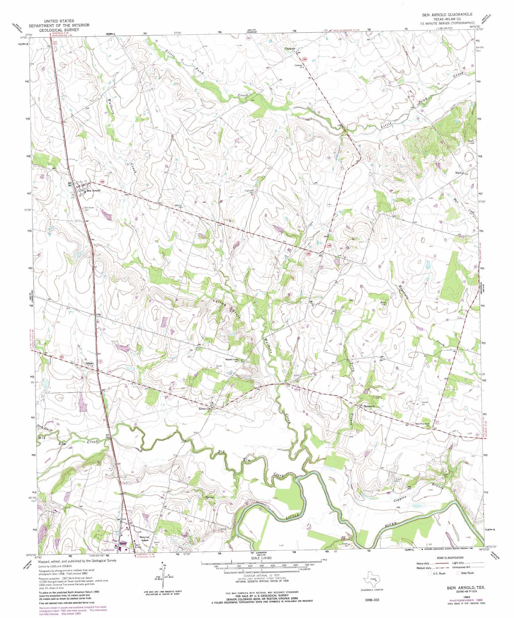
Ben Arnold Topo Map Texas
To zoom in, hover over the map of Ben Arnold
USGS Topo Quad 30096h8 - 1:24,000 scale
| Topo Map Name: | Ben Arnold |
| USGS Topo Quad ID: | 30096h8 |
| Print Size: | ca. 21 1/4" wide x 27" high |
| Southeast Coordinates: | 30.875° N latitude / 96.875° W longitude |
| Map Center Coordinates: | 30.9375° N latitude / 96.9375° W longitude |
| U.S. State: | TX |
| Filename: | o30096h8.jpg |
| Download Map JPG Image: | Ben Arnold topo map 1:24,000 scale |
| Map Type: | Topographic |
| Topo Series: | 7.5´ |
| Map Scale: | 1:24,000 |
| Source of Map Images: | United States Geological Survey (USGS) |
| Alternate Map Versions: |
Ben Arnold TX 1962, updated 1964 Download PDF Buy paper map Ben Arnold TX 1962, updated 1989 Download PDF Buy paper map Ben Arnold TX 2010 Download PDF Buy paper map Ben Arnold TX 2013 Download PDF Buy paper map Ben Arnold TX 2016 Download PDF Buy paper map |
1:24,000 Topo Quads surrounding Ben Arnold
Belfalls |
Lott |
Cedar Springs |
Reagan |
Bremond |
Seaton |
Westphalia |
Rosebud |
Baileyville |
Hammond |
Rogers |
Yarrelton |
Ben Arnold |
Maysfield |
Calvert |
Sharp |
Pettibone |
Cameron |
Hanover |
Gause |
San Gabriel |
Rockdale West |
Rockdale East |
Milano |
Goodwill |
> Back to 30096e1 at 1:100,000 scale
> Back to 30096a1 at 1:250,000 scale
> Back to U.S. Topo Maps home
Ben Arnold topo map: Gazetteer
Ben Arnold: Airports
Cameron Municipal Airpark elevation 121m 396′Ben Arnold: Cliffs
Yellow Bluff elevation 114m 374′Ben Arnold: Dams
Cobb Lake Dam elevation 108m 354′Elm Creek Farm Dam Number 1 elevation 111m 364′
Hudson Lake Dam elevation 105m 344′
Knight Lake Dam elevation 97m 318′
Thomas Estate Lake Dam elevation 103m 337′
Ben Arnold: Populated Places
Belmena elevation 110m 360′Ben Arnold elevation 121m 396′
Clarkson elevation 116m 380′
Quinif elevation 123m 403′
Silver City elevation 104m 341′
Splawn elevation 107m 351′
Ben Arnold: Reservoirs
Cobb Lake elevation 108m 354′Elm Creek Farm Lake Number 1 elevation 111m 364′
Hudson Lake elevation 105m 344′
Knight Lake elevation 97m 318′
Thomas Estate Lake elevation 103m 337′
Ben Arnold: Springs
Indian Springs elevation 106m 347′Ben Arnold: Streams
Big Elm Creek elevation 86m 282′Coppers Branch elevation 86m 282′
North Elm Creek elevation 95m 311′
Terry Branch elevation 88m 288′
Walkers Creek elevation 86m 282′
Ben Arnold digital topo map on disk
Buy this Ben Arnold topo map showing relief, roads, GPS coordinates and other geographical features, as a high-resolution digital map file on DVD: