Mount Livermore Topo Map Texas
To zoom in, hover over the map of Mount Livermore
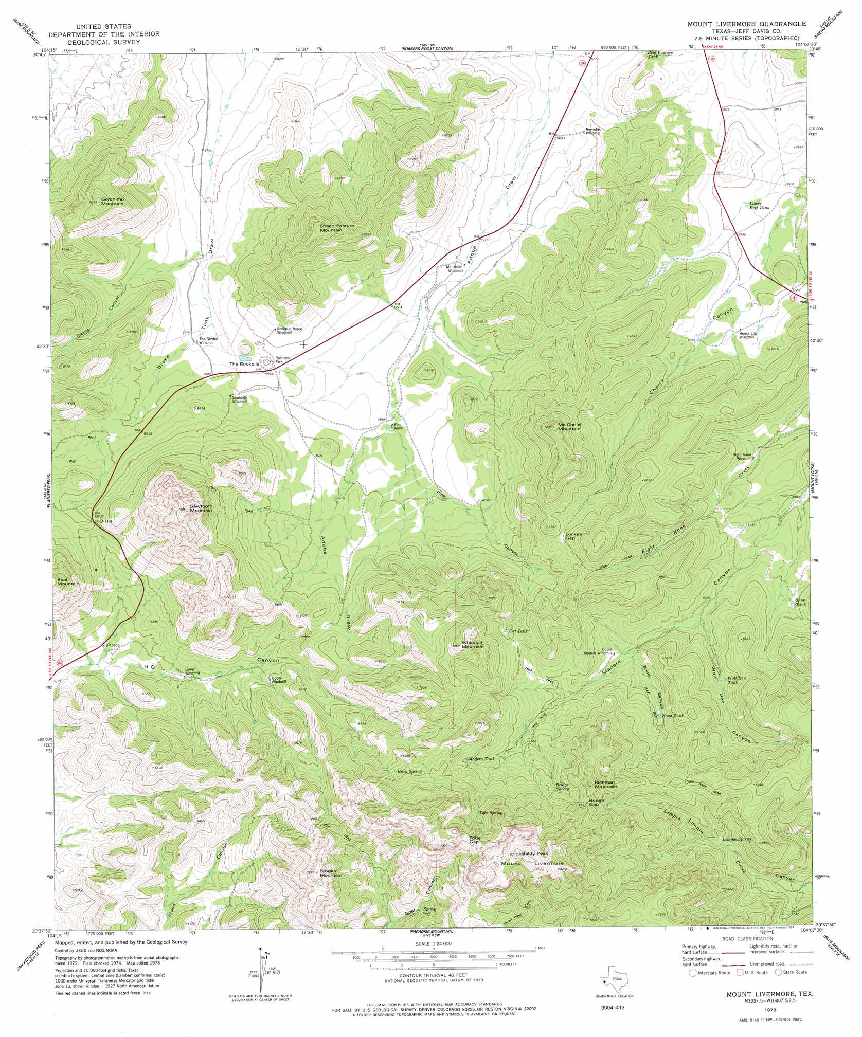
USGS Topo Quad 30104f2 - 1:24,000 scale
| Topo Map Name: | Mount Livermore |
| USGS Topo Quad ID: | 30104f2 |
| Print Size: | ca. 21 1/4" wide x 27" high |
| Southeast Coordinates: | 30.625° N latitude / 104.125° W longitude |
| Map Center Coordinates: | 30.6875° N latitude / 104.1875° W longitude |
| U.S. State: | TX |
| Filename: | o30104f2.jpg |
| Download Map JPG Image: | Mount Livermore topo map 1:24,000 scale |
| Map Type: | Topographic |
| Topo Series: | 7.5´ |
| Map Scale: | 1:24,000 |
| Source of Map Images: | United States Geological Survey (USGS) |
| Alternate Map Versions: |
Mount Livermore TX 1978, updated 1978 Download PDF Buy paper map Mount Livermore TX 2010 Download PDF Buy paper map Mount Livermore TX 2012 Download PDF Buy paper map Mount Livermore TX 2016 Download PDF Buy paper map |
1:24,000 Topo Quads surrounding Mount Livermore
Boracho Peak |
Herds Pass |
Echo Canyon |
Buckhorn Mountain |
Antelope Flat |
Boggy Draw |
Bare Mountain |
Robbers Roost Canyon |
Friend Mountain |
Little Aguja Mountain |
Horseshoe Butte |
El Muerto Peak |
Mount Livermore |
Mount Locke |
Casket Mountain |
Valentine East |
San Antonio Pass |
Paradise Mountain |
Blue Mountain |
Fort Davis |
Deer Peak |
Ryan |
Burro Draw |
Smith Hills |
Mano Prieto Mountain |
> Back to 30104e1 at 1:100,000 scale
> Back to 30104a1 at 1:250,000 scale
> Back to U.S. Topo Maps home
Mount Livermore topo map: Gazetteer
Mount Livermore: Gaps
Bridge Gap elevation 2228m 7309′Lockes Gap elevation 2010m 6594′
Tobe Gap elevation 2344m 7690′
Mount Livermore: Reservoirs
Beef Pasture Tank elevation 1767m 5797′Cat Tank elevation 2001m 6564′
Lower Beef Tank elevation 1818m 5964′
Madera Tank elevation 2068m 6784′
Road Tank elevation 1935m 6348′
Shoe Tank elevation 1871m 6138′
Wolf Den Tank elevation 1912m 6272′
Mount Livermore: Springs
Bridge Spring elevation 2095m 6873′Horn Spring elevation 2097m 6879′
Limpia Spring elevation 1919m 6295′
Tobe Spring elevation 2148m 7047′
Mount Livermore: Summits
Baldy Peak elevation 2537m 8323′Brooks Mountain elevation 2365m 7759′
Geronimo Mountain elevation 2119m 6952′
H O Hill elevation 1898m 6227′
McDaniel Mountain elevation 2200m 7217′
Mount Livermore elevation 2492m 8175′
Richman Mountain elevation 2315m 7595′
Sawtooth Mountain elevation 2333m 7654′
Sheep Pasture Mountain elevation 2112m 6929′
The Rockpile elevation 1844m 6049′
Whitetail Mountain elevation 2281m 7483′
Mount Livermore: Trails
Davis Mountains Preserve Trail System elevation 2164m 7099′Mount Livermore: Valleys
Clovis Canyon elevation 1827m 5994′Pine Canyon elevation 1814m 5951′
Road Canyon elevation 1896m 6220′
Wolf Den Canyon elevation 1865m 6118′
Mount Livermore: Wells
Fon Wells elevation 1800m 5905′Mount Livermore digital topo map on disk
Buy this Mount Livermore topo map showing relief, roads, GPS coordinates and other geographical features, as a high-resolution digital map file on DVD: