Whitewater Creek Topo Map New Mexico
To zoom in, hover over the map of Whitewater Creek
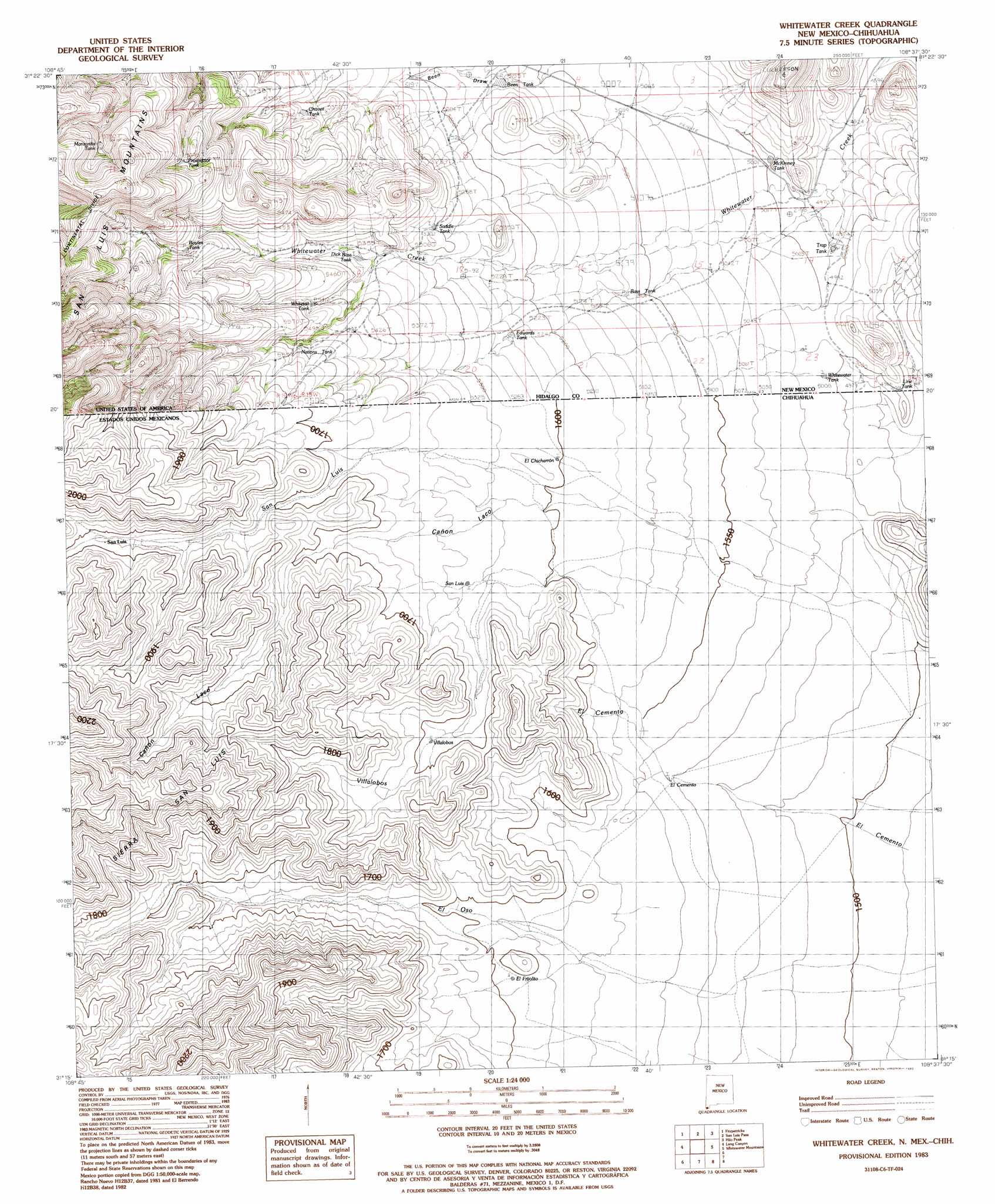
USGS Topo Quad 31108c6 - 1:24,000 scale
| Topo Map Name: | Whitewater Creek |
| USGS Topo Quad ID: | 31108c6 |
| Print Size: | ca. 21 1/4" wide x 27" high |
| Southeast Coordinates: | 31.25° N latitude / 108.625° W longitude |
| Map Center Coordinates: | 31.3125° N latitude / 108.6875° W longitude |
| U.S. State: | NM |
| Filename: | o31108c6.jpg |
| Download Map JPG Image: | Whitewater Creek topo map 1:24,000 scale |
| Map Type: | Topographic |
| Topo Series: | 7.5´ |
| Map Scale: | 1:24,000 |
| Source of Map Images: | United States Geological Survey (USGS) |
| Alternate Map Versions: |
Whitewater Creek NM 1983, updated 1983 Download PDF Buy paper map Whitewater Creek NM 2010 Download PDF Buy paper map Whitewater Creek NM 2013 Download PDF Buy paper map Whitewater Creek NM 2017 Download PDF Buy paper map |
1:24,000 Topo Quads surrounding Whitewater Creek
Clanton Draw |
Animas Peak |
Center Peak |
Horse Mountain |
U Bar Ridge |
Black Point |
Fitzpatricks |
San Luis Pass |
Hilo Peak |
Sentinel Butte |
Guadalupe Pass |
Lang Canyon |
Whitewater Creek |
Whitewater Mountains |
Eagle Mountain |
> Back to 31108a1 at 1:100,000 scale
> Back to 31108a1 at 1:250,000 scale
> Back to U.S. Topo Maps home
Whitewater Creek topo map: Gazetteer
Whitewater Creek: Reservoirs
Bass Tank elevation 1561m 5121′Been Tank elevation 1568m 5144′
Boyles Tank elevation 1687m 5534′
Chavez Tank elevation 1628m 5341′
Dick Bass Tank elevation 1630m 5347′
Edwards Tank elevation 1596m 5236′
Manzanita Tank elevation 1760m 5774′
McKinney Tank elevation 1525m 5003′
Nations Tank elevation 1560m 5118′
Prospector Tank elevation 1737m 5698′
Saddle Tank elevation 1618m 5308′
Trap Tank elevation 1519m 4983′
Whitetail Tank elevation 1651m 5416′
Whitewater Tank elevation 1532m 5026′
Whitewater Creek: Streams
Whitewater Creek elevation 1540m 5052′Whitewater Creek: Trails
Packers Trail elevation 1689m 5541′Whitewater Creek digital topo map on disk
Buy this Whitewater Creek topo map showing relief, roads, GPS coordinates and other geographical features, as a high-resolution digital map file on DVD: