Bartlett Mountain Topo Map Arizona
To zoom in, hover over the map of Bartlett Mountain
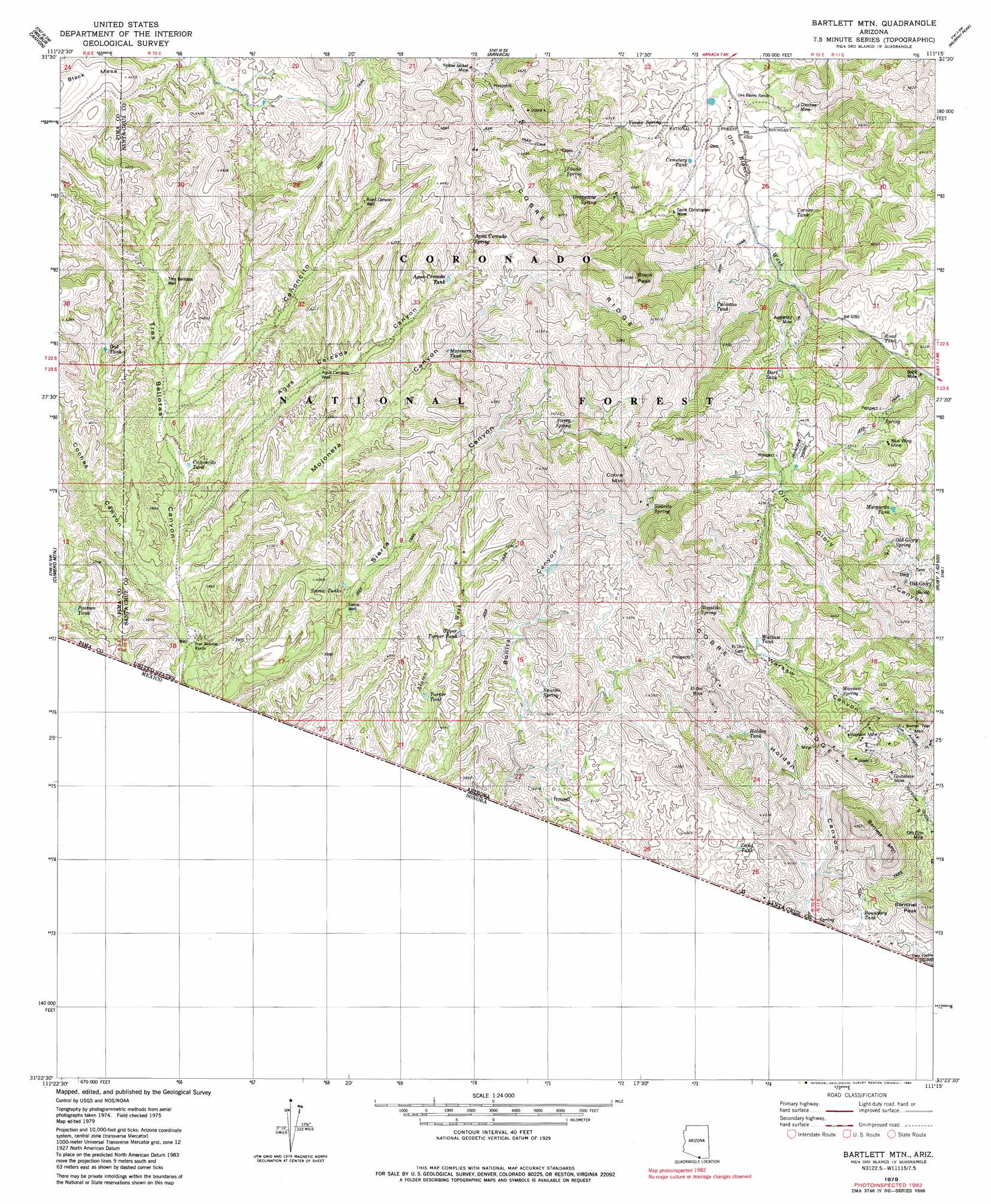
USGS Topo Quad 31111d3 - 1:24,000 scale
| Topo Map Name: | Bartlett Mountain |
| USGS Topo Quad ID: | 31111d3 |
| Print Size: | ca. 21 1/4" wide x 27" high |
| Southeast Coordinates: | 31.375° N latitude / 111.25° W longitude |
| Map Center Coordinates: | 31.4375° N latitude / 111.3125° W longitude |
| U.S. State: | AZ |
| Filename: | o31111d3.jpg |
| Download Map JPG Image: | Bartlett Mountain topo map 1:24,000 scale |
| Map Type: | Topographic |
| Topo Series: | 7.5´ |
| Map Scale: | 1:24,000 |
| Source of Map Images: | United States Geological Survey (USGS) |
| Alternate Map Versions: |
Bartlett Mtn AZ 1979, updated 1979 Download PDF Buy paper map Bartlett Mtn AZ 1979, updated 1984 Download PDF Buy paper map Bartlett Mountain AZ 2004, updated 2007 Download PDF Buy paper map Bartlett Mountain AZ 2012 Download PDF Buy paper map Bartlett Mountain AZ 2014 Download PDF Buy paper map |
| FStopo: | US Forest Service topo Bartlett Mountain is available: Download FStopo PDF Download FStopo TIF |
1:24,000 Topo Quads surrounding Bartlett Mountain
Mildred Peak |
Las Guijas |
Cerro Colorado |
Saucito Mountain |
Amado |
Presumido Peak |
Wilbur Canyon |
Arivaca |
Murphy Peak |
Tubac |
Sasabe |
Cumero Mountain |
Bartlett Mountain |
Ruby |
Pena Blanca Lake |
Alamo Spring |
Pajarito Peak |
|||
> Back to 31111a1 at 1:100,000 scale
> Back to 31110a1 at 1:250,000 scale
> Back to U.S. Topo Maps home
Bartlett Mountain topo map: Gazetteer
Bartlett Mountain: Dams
Oro Blanco Dam elevation 1207m 3959′Bartlett Mountain: Mines
Alamo Mine elevation 1233m 4045′Austerlitz Mine elevation 1347m 4419′
Brick Mine elevation 1277m 4189′
Choctaw Mine elevation 1237m 4058′
El Oro Mine elevation 1242m 4074′
Oro Fino Mine elevation 1145m 3756′
Saint Christopher Mine elevation 1267m 4156′
Yellow Jacket Mine elevation 1296m 4251′
Bartlett Mountain: Populated Places
Casa Piedra elevation 1076m 3530′Old Glory elevation 1235m 4051′
Oro Blanco elevation 1208m 3963′
Partridge (historical) elevation 1235m 4051′
Bartlett Mountain: Reservoirs
Agua Cercada Tank elevation 1248m 4094′Bonita Tank elevation 1228m 4028′
Boundary Tank elevation 1128m 3700′
Cemetery Tank elevation 1231m 4038′
Corner Tank elevation 1259m 4130′
Dart Tank elevation 1341m 4399′
Holden Tank elevation 1183m 3881′
Japanese Tank elevation 1320m 4330′
Land Tank elevation 1218m 3996′
Margarita Tank elevation 1310m 4297′
Oak Tank elevation 1205m 3953′
Oro Blanco Reservoir elevation 1207m 3959′
Palomas Tank elevation 1328m 4356′
Pasture Tank elevation 1168m 3832′
Road Tank elevation 1278m 4192′
Saucita Tank elevation 1303m 4274′
Sierra Tanks elevation 1172m 3845′
Turner Tank elevation 1192m 3910′
Upper Turner Tank elevation 1222m 4009′
Warsaw Tank elevation 1282m 4206′
Yellow Jacket Tank elevation 1307m 4288′
Bartlett Mountain: Ridges
Cobre Ridge elevation 1494m 4901′Bartlett Mountain: Springs
Agua Cercada Spring elevation 1290m 4232′Grapevine Spring elevation 1283m 4209′
Nogalito Spring elevation 1273m 4176′
Old Glory Spring elevation 1231m 4038′
Saucito Spring elevation 1190m 3904′
Saucito Spring elevation 1325m 4347′
Sierra Spring elevation 1297m 4255′
Skunk Spring elevation 1289m 4229′
Warsaw Spring elevation 1252m 4107′
Yanks Spring elevation 1232m 4041′
Bartlett Mountain: Streams
Cantina Wash elevation 1089m 3572′Bartlett Mountain: Summits
Bartlett Mountain elevation 1347m 4419′Black Peak elevation 1534m 5032′
Cobre Mountain elevation 1502m 4927′
Sentinel Peak elevation 1244m 4081′
Bartlett Mountain: Valleys
Agua Cercada Canyon elevation 1144m 3753′Bonita Canyon elevation 1116m 3661′
California Gulch elevation 1039m 3408′
Cañoncito elevation 1167m 3828′
Coches Canyon elevation 1130m 3707′
Holden Canyon elevation 1131m 3710′
Japanese Valley elevation 1314m 4311′
Mojonera Canyon elevation 1140m 3740′
Sierra Canyon elevation 1102m 3615′
Bartlett Mountain: Wells
Agua Cercada Well elevation 1206m 3956′Mojonera Well elevation 1233m 4045′
Road Canyon Well elevation 1260m 4133′
Sierra Well elevation 1164m 3818′
Tres Bellotas Well elevation 1204m 3950′
Bartlett Mountain digital topo map on disk
Buy this Bartlett Mountain topo map showing relief, roads, GPS coordinates and other geographical features, as a high-resolution digital map file on DVD: