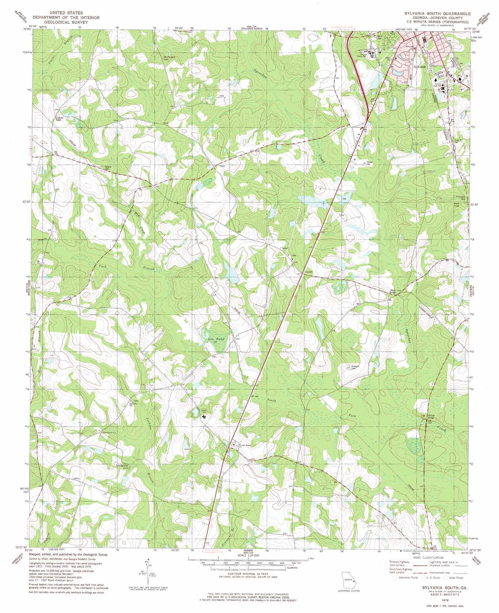
Sylvania South Topo Map Georgia
To zoom in, hover over the map of Sylvania South
USGS Topo Quad 32081f6 - 1:24,000 scale
| Topo Map Name: | Sylvania South |
| USGS Topo Quad ID: | 32081f6 |
| Print Size: | ca. 21 1/4" wide x 27" high |
| Southeast Coordinates: | 32.625° N latitude / 81.625° W longitude |
| Map Center Coordinates: | 32.6875° N latitude / 81.6875° W longitude |
| U.S. State: | GA |
| Filename: | o32081f6.jpg |
| Download Map JPG Image: | Sylvania South topo map 1:24,000 scale |
| Map Type: | Topographic |
| Topo Series: | 7.5´ |
| Map Scale: | 1:24,000 |
| Source of Map Images: | United States Geological Survey (USGS) |
| Alternate Map Versions: |
Sylvania South GA 1978, updated 1978 Download PDF Buy paper map Sylvania South GA 2011 Download PDF Buy paper map Sylvania South GA 2014 Download PDF Buy paper map |
1:24,000 Topo Quads surrounding Sylvania South
Perkins |
Sardis |
Hilltonia |
Burtons Ferry Landing |
Bull Pond |
Millen |
Bay Branch |
Sylvania North |
Jacksonboro Bridge |
Brier Creek Landing |
Four Points |
Rocky Ford |
Sylvania South |
Hunters |
Blue Springs Landing |
Portal |
Hopeulikit |
Dover |
Oliver |
Kildare |
Pulaski |
Statesboro |
Brooklet |
Leefield |
Egypt |
> Back to 32081e1 at 1:100,000 scale
> Back to 32080a1 at 1:250,000 scale
> Back to U.S. Topo Maps home
Sylvania South topo map: Gazetteer
Sylvania South: Bridges
Bests Bridge elevation 47m 154′McCall Bridge elevation 41m 134′
Sylvania South: Dams
Bennett Lake Dam elevation 62m 203′Blalock Pond Dam elevation 59m 193′
Freeman Pond Dam elevation 53m 173′
Miller Pond Dam elevation 62m 203′
Nelson Pond Dam elevation 54m 177′
Robinson Pond Dam elevation 65m 213′
Sylvania South: Lakes
Lee Pond elevation 52m 170′Sylvania South: Populated Places
Altman elevation 72m 236′Double Heads elevation 63m 206′
Goloid elevation 73m 239′
Sylvania South: Post Offices
Sylvania Post Office elevation 70m 229′Sylvania South: Reservoirs
Bennett Lake elevation 62m 203′Blalock Pond elevation 59m 193′
Freemam Pond elevation 53m 173′
Miller Pond elevation 62m 203′
Nelson Pond elevation 54m 177′
Robinson Pond elevation 65m 213′
Sylvania South: Streams
Carter Branch elevation 71m 232′Hen Coop Branch elevation 51m 167′
South Fork Ogeechee Creek elevation 41m 134′
Sylvania South digital topo map on disk
Buy this Sylvania South topo map showing relief, roads, GPS coordinates and other geographical features, as a high-resolution digital map file on DVD:
South Carolina, Western North Carolina & Northeastern Georgia
Buy digital topo maps: South Carolina, Western North Carolina & Northeastern Georgia