Four Points Topo Map Georgia
To zoom in, hover over the map of Four Points
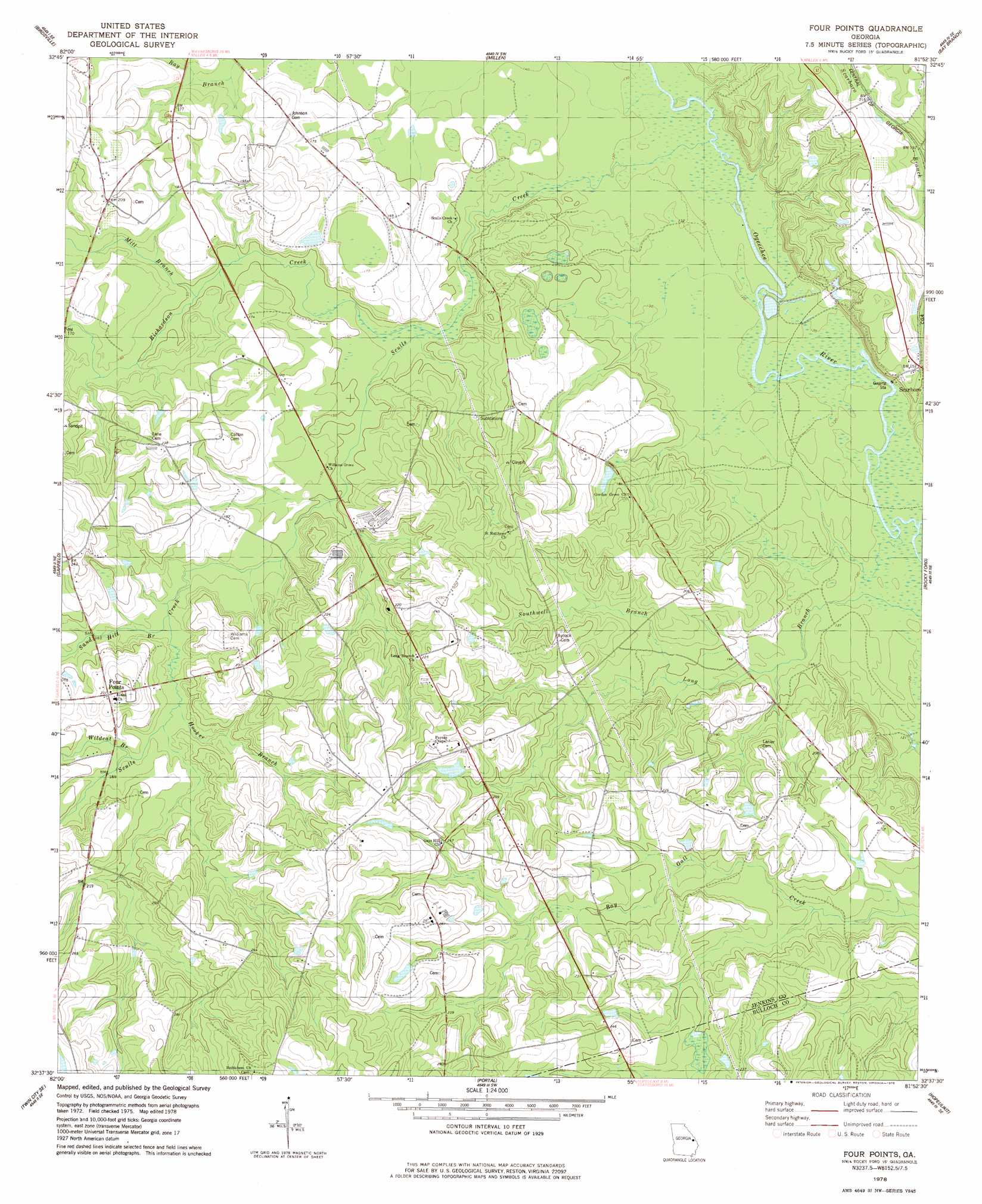
USGS Topo Quad 32081f8 - 1:24,000 scale
| Topo Map Name: | Four Points |
| USGS Topo Quad ID: | 32081f8 |
| Print Size: | ca. 21 1/4" wide x 27" high |
| Southeast Coordinates: | 32.625° N latitude / 81.875° W longitude |
| Map Center Coordinates: | 32.6875° N latitude / 81.9375° W longitude |
| U.S. State: | GA |
| Filename: | o32081f8.jpg |
| Download Map JPG Image: | Four Points topo map 1:24,000 scale |
| Map Type: | Topographic |
| Topo Series: | 7.5´ |
| Map Scale: | 1:24,000 |
| Source of Map Images: | United States Geological Survey (USGS) |
| Alternate Map Versions: |
Four Points GA 1978, updated 1978 Download PDF Buy paper map Four Points GA 2011 Download PDF Buy paper map Four Points GA 2014 Download PDF Buy paper map |
1:24,000 Topo Quads surrounding Four Points
Scotts Corner |
Bellevue |
Perkins |
Sardis |
Hilltonia |
Midville |
Birdsville |
Millen |
Bay Branch |
Sylvania North |
Canoochee |
Garfield |
Four Points |
Rocky Ford |
Sylvania South |
Twin City |
Twin City Se |
Portal |
Hopeulikit |
Dover |
Stillmore |
Metter |
Pulaski |
Statesboro |
Brooklet |
> Back to 32081e1 at 1:100,000 scale
> Back to 32080a1 at 1:250,000 scale
> Back to U.S. Topo Maps home
Four Points topo map: Gazetteer
Four Points: Dams
Milburne Lake Dam elevation 62m 203′Newton Lake Dam elevation 51m 167′
Four Points: Populated Places
Four Points elevation 70m 229′Scarboro elevation 48m 157′
Four Points: Reservoirs
Milburne Lake elevation 62m 203′Newton Lake elevation 51m 167′
Four Points: Streams
Hooker Branch elevation 52m 170′Mill Branch elevation 45m 147′
Richardson Creek elevation 42m 137′
Sand Hill Branch elevation 49m 160′
Scarboro Branch elevation 35m 114′
Sculls Creek elevation 37m 121′
Southwell Branch elevation 44m 144′
Wildcat Branch elevation 54m 177′
Four Points digital topo map on disk
Buy this Four Points topo map showing relief, roads, GPS coordinates and other geographical features, as a high-resolution digital map file on DVD:
South Carolina, Western North Carolina & Northeastern Georgia
Buy digital topo maps: South Carolina, Western North Carolina & Northeastern Georgia