Brier Creek Landing Topo Map Georgia
To zoom in, hover over the map of Brier Creek Landing
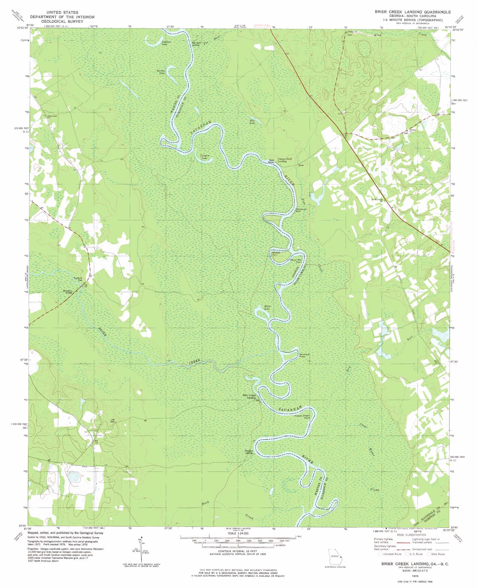
USGS Topo Quad 32081g4 - 1:24,000 scale
| Topo Map Name: | Brier Creek Landing |
| USGS Topo Quad ID: | 32081g4 |
| Print Size: | ca. 21 1/4" wide x 27" high |
| Southeast Coordinates: | 32.75° N latitude / 81.375° W longitude |
| Map Center Coordinates: | 32.8125° N latitude / 81.4375° W longitude |
| U.S. States: | GA, SC |
| Filename: | o32081g4.jpg |
| Download Map JPG Image: | Brier Creek Landing topo map 1:24,000 scale |
| Map Type: | Topographic |
| Topo Series: | 7.5´ |
| Map Scale: | 1:24,000 |
| Source of Map Images: | United States Geological Survey (USGS) |
| Alternate Map Versions: |
Brier Creek Landing GA 1978, updated 1978 Download PDF Buy paper map Brier Creek Landing GA 2011 Download PDF Buy paper map Brier Creek Landing GA 2014 Download PDF Buy paper map |
1:24,000 Topo Quads surrounding Brier Creek Landing
Girard |
Millett |
Martin |
Allendale |
Sycamore |
Hilltonia |
Burtons Ferry Landing |
Bull Pond |
Barton |
Fairfax |
Sylvania North |
Jacksonboro Bridge |
Brier Creek Landing |
Solomons Crossroads |
Gifford |
Sylvania South |
Hunters |
Blue Springs Landing |
Shirley |
Furman |
Dover |
Oliver |
Kildare |
Brighton |
Pineland |
> Back to 32081e1 at 1:100,000 scale
> Back to 32080a1 at 1:250,000 scale
> Back to U.S. Topo Maps home
Brier Creek Landing topo map: Gazetteer
Brier Creek Landing: Bridges
Brannons Bridge elevation 18m 59′Brier Creek Landing: Capes
Fridays Dream Point elevation 13m 42′Red Bluff Point elevation 16m 52′
Saucy Boy Point elevation 14m 45′
Whirligig Point elevation 13m 42′
Wildcat Point elevation 15m 49′
Brier Creek Landing: Cliffs
Cohens Bluff elevation 18m 59′Matthews Bluff elevation 15m 49′
Brier Creek Landing: Dams
Hagan Pond Dam elevation 29m 95′Brier Creek Landing: Lakes
Barnes Lake elevation 15m 49′Blue Lake elevation 18m 59′
Conyers Lake elevation 15m 49′
Johnson Lake elevation 16m 52′
Miller Lake elevation 13m 42′
Brier Creek Landing: Populated Places
Brier Creek Landing elevation 15m 49′Cohens Bluff Landing elevation 18m 59′
Pfeiffer (historical) elevation 15m 49′
Red Bluff Landing elevation 15m 49′
Ruddell (historical) elevation 24m 78′
Brier Creek Landing: Reservoirs
Hagan Pond elevation 29m 95′Brier Creek Landing: Streams
Brier Creek elevation 15m 49′Buck Creek elevation 12m 39′
Dry Gall elevation 13m 42′
King Creek elevation 17m 55′
Pipe Creek elevation 13m 42′
The Gaul elevation 15m 49′
Brier Creek Landing digital topo map on disk
Buy this Brier Creek Landing topo map showing relief, roads, GPS coordinates and other geographical features, as a high-resolution digital map file on DVD:
South Carolina, Western North Carolina & Northeastern Georgia
Buy digital topo maps: South Carolina, Western North Carolina & Northeastern Georgia