Agua Caliente Topo Map Arizona
To zoom in, hover over the map of Agua Caliente
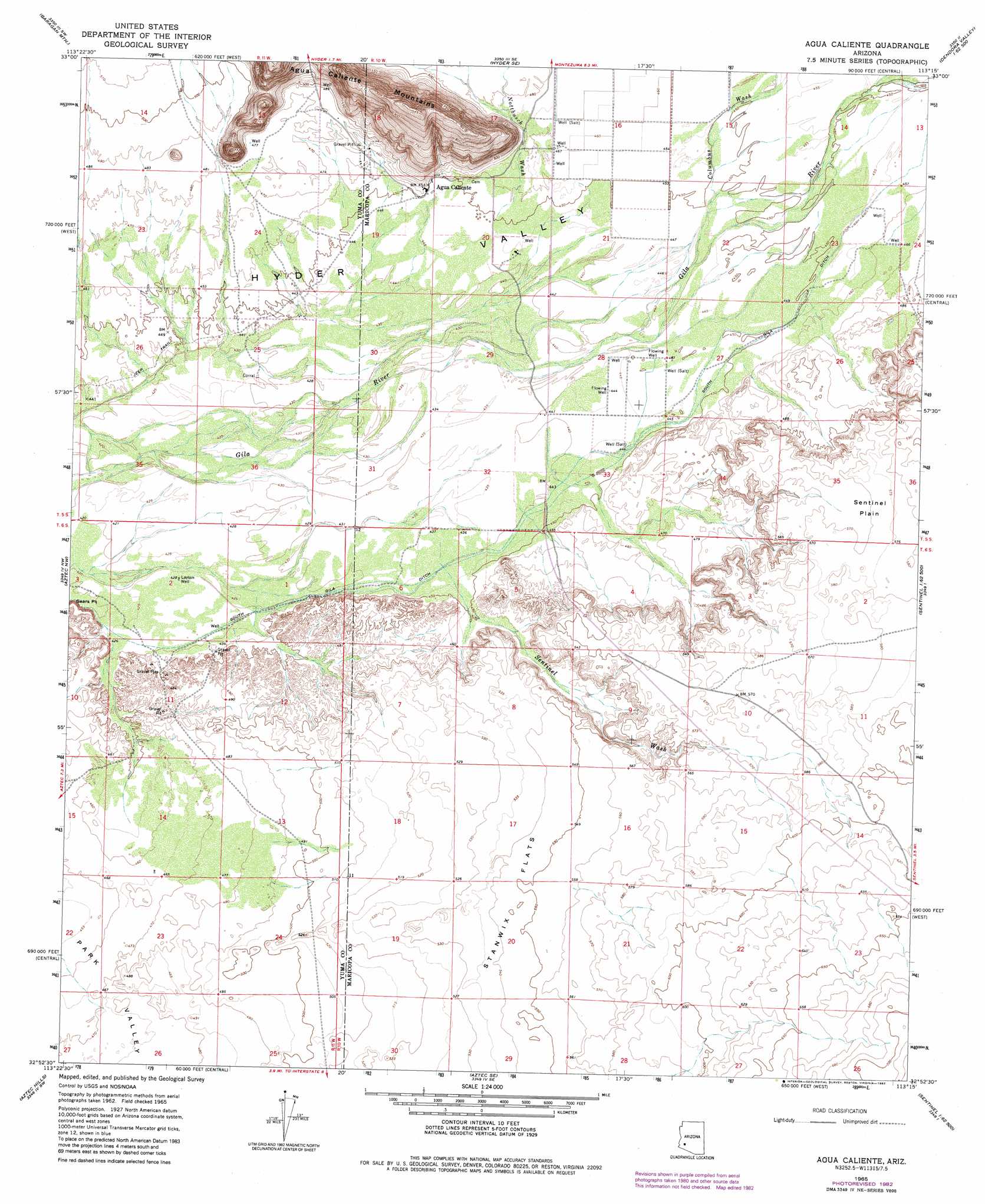
USGS Topo Quad 32113h3 - 1:24,000 scale
| Topo Map Name: | Agua Caliente |
| USGS Topo Quad ID: | 32113h3 |
| Print Size: | ca. 21 1/4" wide x 27" high |
| Southeast Coordinates: | 32.875° N latitude / 113.25° W longitude |
| Map Center Coordinates: | 32.9375° N latitude / 113.3125° W longitude |
| U.S. State: | AZ |
| Filename: | o32113h3.jpg |
| Download Map JPG Image: | Agua Caliente topo map 1:24,000 scale |
| Map Type: | Topographic |
| Topo Series: | 7.5´ |
| Map Scale: | 1:24,000 |
| Source of Map Images: | United States Geological Survey (USGS) |
| Alternate Map Versions: |
Agua Caliente AZ 1965, updated 1966 Download PDF Buy paper map Agua Caliente AZ 1965, updated 1978 Download PDF Buy paper map Agua Caliente AZ 1965, updated 1982 Download PDF Buy paper map Agua Caliente AZ 2011 Download PDF Buy paper map Agua Caliente AZ 2014 Download PDF Buy paper map |
1:24,000 Topo Quads surrounding Agua Caliente
Palomas Mountains Ne |
Turtleback Mountain |
Hyder Ne |
Yellow Medicine Butte |
Quail Spring Wash |
Palomas Mountains Se |
Baragan Mountain |
Hyder |
Oatman Mountain |
Dendora Valley |
Horn |
Aztec Nw |
Agua Caliente |
Sentinel Peak |
Sentinel Ne |
Dateland |
Aztec Hills |
Aztec Se |
Sentinel |
Sentinel Se |
Hohawk Mountains Ne |
Aguila Mountains Nw |
Aguila Mountains Ne |
South Of Sentinel |
Malpais Hill |
> Back to 32113e1 at 1:100,000 scale
> Back to 32112a1 at 1:250,000 scale
> Back to U.S. Topo Maps home
Agua Caliente topo map: Gazetteer
Agua Caliente: Canals
South Gila Ditch elevation 130m 426′Agua Caliente: Plains
Sentinel Plain elevation 0m 0′Agua Caliente: Populated Places
Agua Caliente elevation 139m 456′Agua Caliente: Streams
Columbus Wash elevation 136m 446′Copper Wash elevation 138m 452′
Nottbusch Wash elevation 140m 459′
Sentinel Wash elevation 0m 0′
Agua Caliente: Summits
Agua Caliente Mountains elevation 267m 875′Agua Caliente: Valleys
Hyder Valley elevation 136m 446′Agua Caliente: Wells
Browns Well elevation 134m 439′Layton Well elevation 130m 426′
Agua Caliente digital topo map on disk
Buy this Agua Caliente topo map showing relief, roads, GPS coordinates and other geographical features, as a high-resolution digital map file on DVD: