Denmark Topo Map South Carolina
To zoom in, hover over the map of Denmark
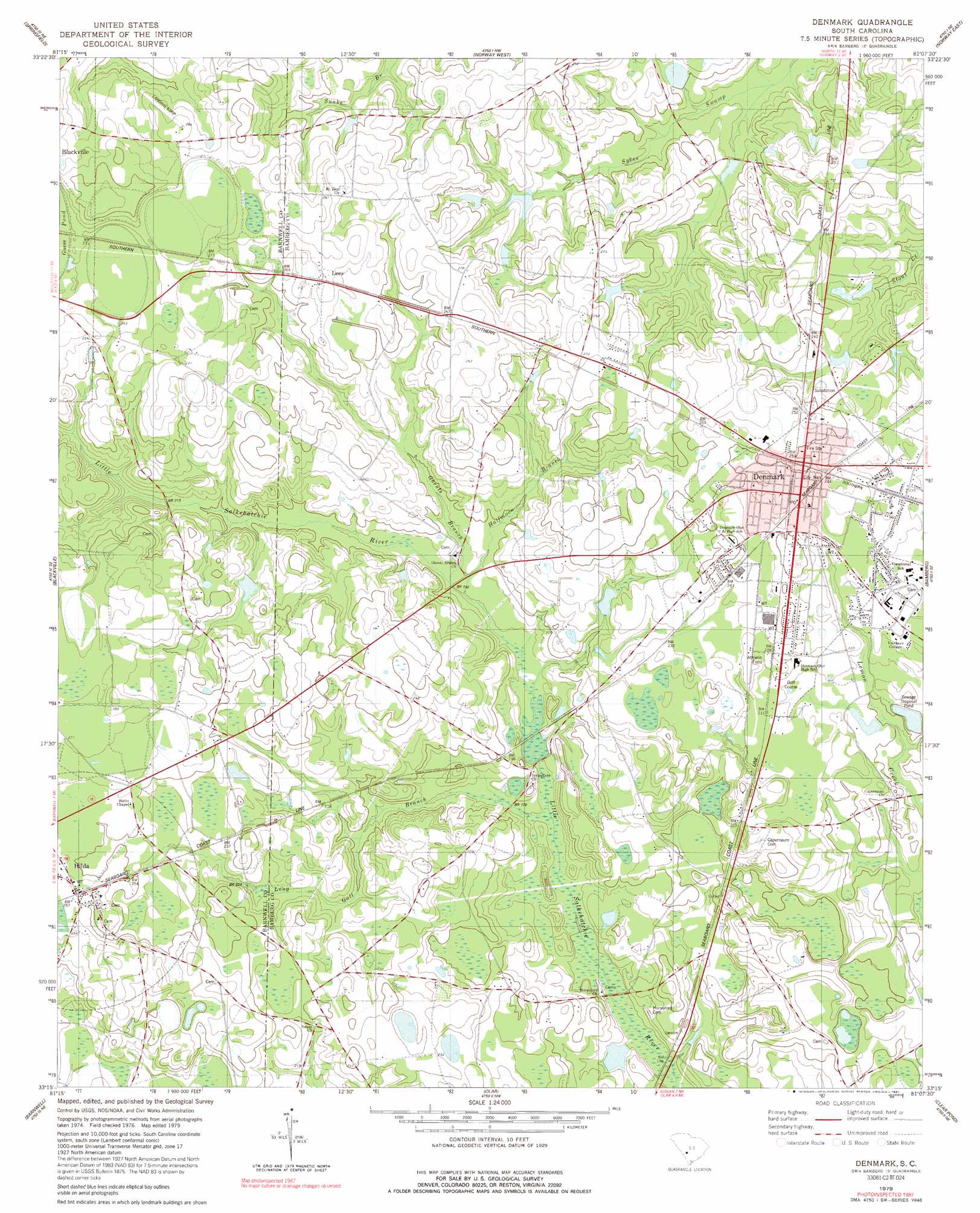
USGS Topo Quad 33081c2 - 1:24,000 scale
| Topo Map Name: | Denmark |
| USGS Topo Quad ID: | 33081c2 |
| Print Size: | ca. 21 1/4" wide x 27" high |
| Southeast Coordinates: | 33.25° N latitude / 81.125° W longitude |
| Map Center Coordinates: | 33.3125° N latitude / 81.1875° W longitude |
| U.S. State: | SC |
| Filename: | o33081c2.jpg |
| Download Map JPG Image: | Denmark topo map 1:24,000 scale |
| Map Type: | Topographic |
| Topo Series: | 7.5´ |
| Map Scale: | 1:24,000 |
| Source of Map Images: | United States Geological Survey (USGS) |
| Alternate Map Versions: |
Denmark SC 1979, updated 1980 Download PDF Buy paper map Denmark SC 1979, updated 1991 Download PDF Buy paper map Denmark SC 2011 Download PDF Buy paper map Denmark SC 2014 Download PDF Buy paper map |
1:24,000 Topo Quads surrounding Denmark
Kitchings Mill |
Salley |
Harleys Millpond |
North |
Wolfton |
Williston |
Springfield |
Norway West |
Norway East |
Cordova |
Long Branch |
Blackville |
Denmark |
Bamberg |
Midway |
Snelling |
Barnwell |
Olar |
Clear Pond |
Tony Hill Bay |
Martin |
Allendale |
Sycamore |
Ehrhardt |
Lodge |
> Back to 33081a1 at 1:100,000 scale
> Back to 33080a1 at 1:250,000 scale
> Back to U.S. Topo Maps home
Denmark topo map: Gazetteer
Denmark: Bridges
Beaverdam Bridge elevation 71m 232′Denmark: Dams
Browns Pond Dam D-2807 elevation 73m 239′Clarks Lake Dam D-2816 elevation 59m 193′
Dobsons Pond Dam D-2811 elevation 50m 164′
Folks Pond Dam D-2814 elevation 61m 200′
Guess Pond Dam D-2809 elevation 67m 219′
Hartzogs Pond Dam D-3056 elevation 69m 226′
Hightower Mill Pond Dam D-2806 elevation 52m 170′
McCains Pond Dam D-2813 elevation 65m 213′
Morris Pond Dam D-2805 elevation 61m 200′
Spells Fish Pond Dam D-2815 elevation 62m 203′
Turners Pond Dam D-2812 elevation 66m 216′
Denmark: Lakes
Buckmire Pond (historical) elevation 83m 272′Flat Pond elevation 58m 190′
Denmark: Parks
Vorhees College Historic District elevation 67m 219′Denmark: Populated Places
Denmark elevation 73m 239′Fogles (historical) elevation 78m 255′
Garris (historical) elevation 61m 200′
Hilda elevation 77m 252′
Lees elevation 83m 272′
Luther (historical) elevation 68m 223′
Rosemary (historical) elevation 82m 269′
Sato elevation 69m 226′
Denmark: Post Offices
Denmark Post Office elevation 73m 239′Hilda Post Office elevation 77m 252′
Denmark: Reservoirs
Hightower Pond elevation 52m 170′Denmark: Streams
Ghents Branch elevation 53m 173′Halfmoon Branch elevation 52m 170′
Long Gall Branch elevation 47m 154′
Denmark: Swamps
Duck Pond elevation 72m 236′Little Wolf Bay elevation 71m 232′
Wolf Bay elevation 70m 229′
Denmark digital topo map on disk
Buy this Denmark topo map showing relief, roads, GPS coordinates and other geographical features, as a high-resolution digital map file on DVD:
South Carolina, Western North Carolina & Northeastern Georgia
Buy digital topo maps: South Carolina, Western North Carolina & Northeastern Georgia