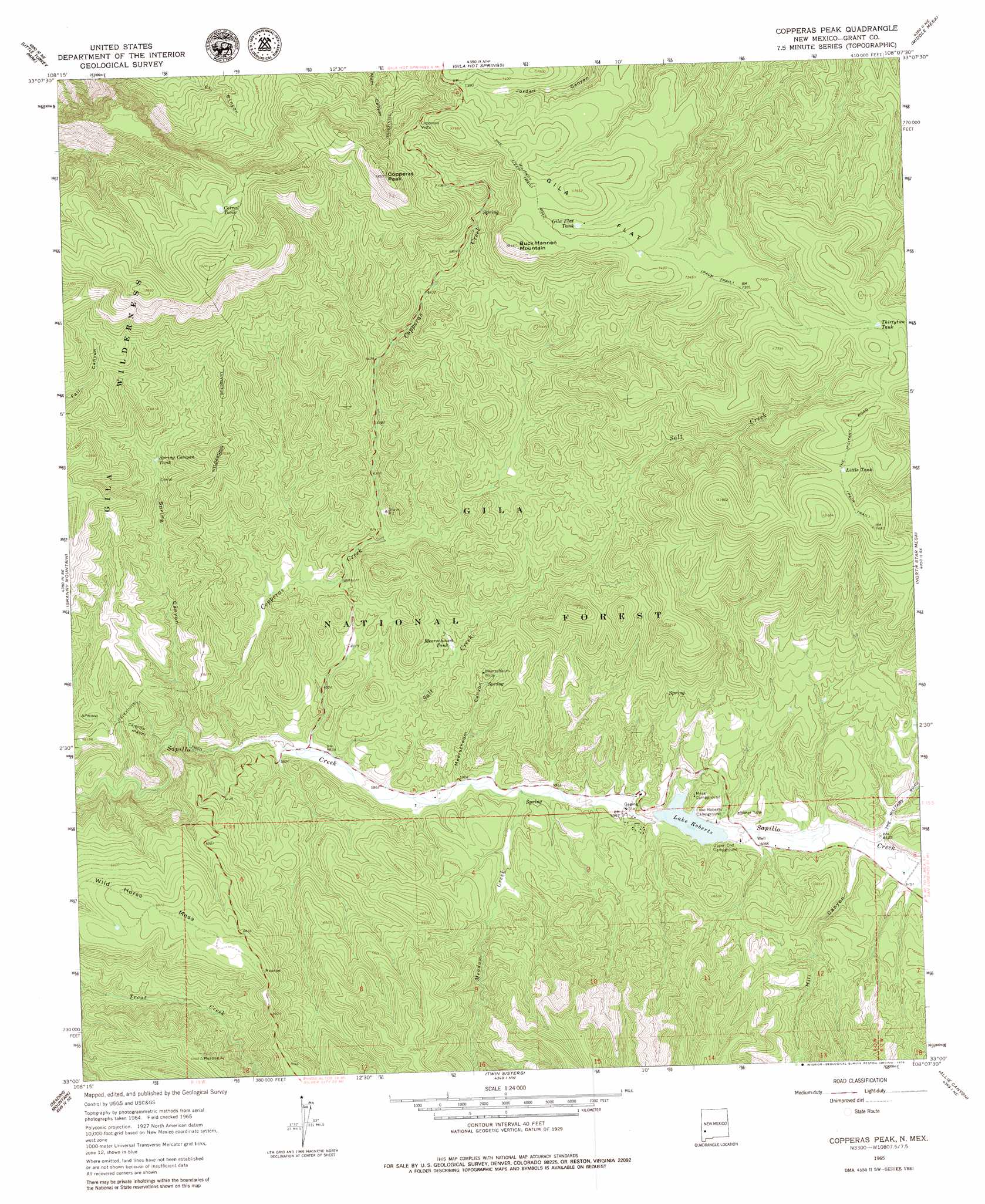
Copperas Peak Topo Map New Mexico
To zoom in, hover over the map of Copperas Peak
USGS Topo Quad 33108a2 - 1:24,000 scale
| Topo Map Name: | Copperas Peak |
| USGS Topo Quad ID: | 33108a2 |
| Print Size: | ca. 21 1/4" wide x 27" high |
| Southeast Coordinates: | 33° N latitude / 108.125° W longitude |
| Map Center Coordinates: | 33.0625° N latitude / 108.1875° W longitude |
| U.S. State: | NM |
| Filename: | o33108a2.jpg |
| Download Map JPG Image: | Copperas Peak topo map 1:24,000 scale |
| Map Type: | Topographic |
| Topo Series: | 7.5´ |
| Map Scale: | 1:24,000 |
| Source of Map Images: | United States Geological Survey (USGS) |
| Alternate Map Versions: |
Copperas Peak NM 1965, updated 1969 Download PDF Buy paper map Copperas Peak NM 1965, updated 1979 Download PDF Buy paper map Copperas Peak NM 1999, updated 2002 Download PDF Buy paper map Copperas Peak NM 2011 Download PDF Buy paper map Copperas Peak NM 2013 Download PDF Buy paper map Copperas Peak NM 2017 Download PDF Buy paper map |
| FStopo: | US Forest Service topo Copperas Peak is available: Download FStopo PDF Download FStopo TIF |
1:24,000 Topo Quads surrounding Copperas Peak
Lilley Mountain |
Woodland Park |
Burnt Corral Canyon |
Wall Lake |
Baily Points |
Diablo Range |
Little Turkey Park |
Gila Hot Springs |
Middle Mesa |
Bonner Canyon |
Canyon Hill |
Granny Mountain |
Copperas Peak |
North Star Mesa |
Hay Mesa |
Dorsey Ranch |
Reading Mountain |
Twin Sisters |
Allie Canyon |
Hendricks Peak |
Circle Mesa |
Silver City |
Fort Bayard |
Santa Rita |
San Lorenzo |
> Back to 33108a1 at 1:100,000 scale
> Back to 33108a1 at 1:250,000 scale
> Back to U.S. Topo Maps home
Copperas Peak topo map: Gazetteer
Copperas Peak: Dams
Lake Roberts Dam elevation 1836m 6023′Copperas Peak: Flats
Gila Flat elevation 2300m 7545′Copperas Peak: Mines
Little Victor Tunnel elevation 1876m 6154′Meerschaum Mine elevation 1907m 6256′
Copperas Peak: Reservoirs
Biddle Tank elevation 1872m 6141′Corral Tank elevation 2278m 7473′
Dry Lake Tank elevation 2249m 7378′
Gila Flat Tank elevation 2242m 7355′
Gila Flat Tank Number Two elevation 2259m 7411′
Jordon Tank elevation 2253m 7391′
Lake Roberts elevation 1836m 6023′
Little Tank elevation 2264m 7427′
Meerschaum Tank elevation 1879m 6164′
No Name Tank elevation 1932m 6338′
Seep Tank elevation 1930m 6332′
Spring Canyon Tank elevation 1909m 6263′
Thirtytwo Tank elevation 2290m 7513′
Copperas Peak: Springs
Alum Spring elevation 1995m 6545′Copperas Spring elevation 2164m 7099′
Meerschaum Spring elevation 1896m 6220′
Salt Creek Spring elevation 2026m 6646′
Copperas Peak: Streams
Copperas Creek elevation 1759m 5770′Meadow Creek elevation 1806m 5925′
Salt Creek elevation 1788m 5866′
Copperas Peak: Summits
Buck Hannen Mountain elevation 2323m 7621′Copperas Peak elevation 2383m 7818′
Wild Horse Mesa elevation 2119m 6952′
Copperas Peak: Trails
The Military Road elevation 2276m 7467′Copperas Peak: Valleys
Hill Canyon elevation 1861m 6105′Meerschaum Canyon elevation 1798m 5898′
Spring Canyon elevation 1749m 5738′
Copperas Peak digital topo map on disk
Buy this Copperas Peak topo map showing relief, roads, GPS coordinates and other geographical features, as a high-resolution digital map file on DVD: