Goosepond Moutain Topo Map Arkansas
To zoom in, hover over the map of Goosepond Moutain
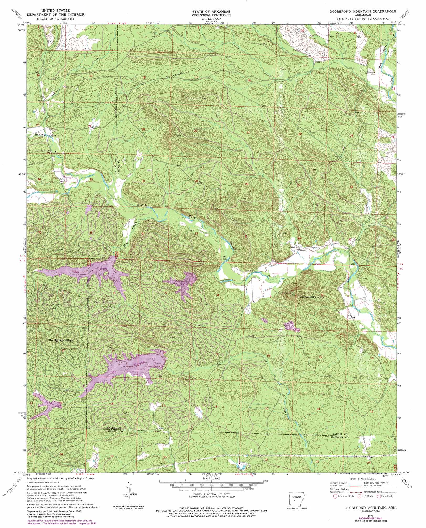
USGS Topo Quad 34092f8 - 1:24,000 scale
| Topo Map Name: | Goosepond Moutain |
| USGS Topo Quad ID: | 34092f8 |
| Print Size: | ca. 21 1/4" wide x 27" high |
| Southeast Coordinates: | 34.625° N latitude / 92.875° W longitude |
| Map Center Coordinates: | 34.6875° N latitude / 92.9375° W longitude |
| U.S. State: | AR |
| Filename: | o34092f8.jpg |
| Download Map JPG Image: | Goosepond Moutain topo map 1:24,000 scale |
| Map Type: | Topographic |
| Topo Series: | 7.5´ |
| Map Scale: | 1:24,000 |
| Source of Map Images: | United States Geological Survey (USGS) |
| Alternate Map Versions: |
Goosepond Mountain AR 1972, updated 1974 Download PDF Buy paper map Goosepond Mountain AR 1972, updated 1977 Download PDF Buy paper map Goosepond Mountain AR 1972, updated 1984 Download PDF Buy paper map Goosepond Mountain AR 2011 Download PDF Buy paper map Goosepond Mountain AR 2014 Download PDF Buy paper map |
1:24,000 Topo Quads surrounding Goosepond Moutain
Nimrod Dam |
Nimrod |
Aplin |
Thornburg |
Martindale |
Nimrod Sw |
Nimrod Se |
Paron Sw |
Paron |
Fourche Sw |
Hamilton |
Jessieville |
Goosepond Moutain |
Lonsdale Ne |
Lake Norrell |
Mountain Pine |
Hot Springs North |
Fountain Lake |
Lonsdale |
Haskell |
Hempwallace |
Hot Springs South |
Lake Catherine |
Malvern North |
Traskwood |
> Back to 34092e1 at 1:100,000 scale
> Back to 34092a1 at 1:250,000 scale
> Back to U.S. Topo Maps home
Goosepond Moutain topo map: Gazetteer
Goosepond Moutain: Dams
Lake Coronado Dam elevation 194m 636′Lake Cortez Dam elevation 195m 639′
Lake Lago Dam elevation 173m 567′
Pineda Dam elevation 213m 698′
Goosepond Moutain: Populated Places
Beaudry (historical) elevation 182m 597′Blocher elevation 153m 501′
Electric (historical) elevation 177m 580′
Hot Springs Village elevation 240m 787′
Goosepond Moutain: Reservoirs
Lake Coronado elevation 194m 636′Lake Cortez elevation 195m 639′
Lake Lago elevation 173m 567′
Lake Pineda elevation 213m 698′
Goosepond Moutain: Streams
Angling Creek elevation 179m 587′Brushy Creek elevation 169m 554′
Little Alum Fork elevation 156m 511′
Mill Creek elevation 191m 626′
Goosepond Moutain: Summits
Goosepond Mountain elevation 326m 1069′Howard Mountain elevation 288m 944′
Goosepond Moutain digital topo map on disk
Buy this Goosepond Moutain topo map showing relief, roads, GPS coordinates and other geographical features, as a high-resolution digital map file on DVD: