Chula Mountain Topo Map Arkansas
To zoom in, hover over the map of Chula Mountain
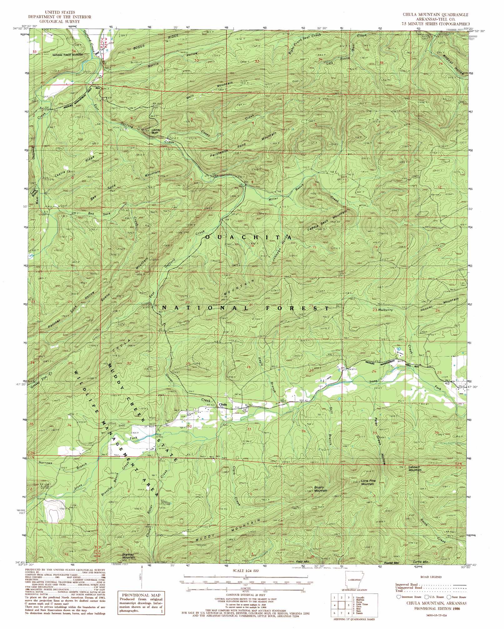
USGS Topo Quad 34093g5 - 1:24,000 scale
| Topo Map Name: | Chula Mountain |
| USGS Topo Quad ID: | 34093g5 |
| Print Size: | ca. 21 1/4" wide x 27" high |
| Southeast Coordinates: | 34.75° N latitude / 93.5° W longitude |
| Map Center Coordinates: | 34.8125° N latitude / 93.5625° W longitude |
| U.S. State: | AR |
| Filename: | o34093g5.jpg |
| Download Map JPG Image: | Chula Mountain topo map 1:24,000 scale |
| Map Type: | Topographic |
| Topo Series: | 7.5´ |
| Map Scale: | 1:24,000 |
| Source of Map Images: | United States Geological Survey (USGS) |
| Alternate Map Versions: |
Chula Mountain AR 1986, updated 1986 Download PDF Buy paper map Chula Mountain AR 2011 Download PDF Buy paper map Chula Mountain AR 2014 Download PDF Buy paper map |
| FStopo: | US Forest Service topo Chula Mountain is available: Download FStopo PDF Download FStopo TIF |
1:24,000 Topo Quads surrounding Chula Mountain
Sugar Grove |
Blue Mountain Dam |
Havana |
Danville |
Danville Mountain |
Freedom Mountain |
Gravelly |
Bluffton |
Rover |
Plainview |
Harvey |
Little Texas |
Chula Mountain |
Onyx |
Steve |
Bushy Creek Mountain |
Sims |
Story |
Fannie |
Avant |
Oden |
Mount Ida |
Reed Mountain |
Mcgraw Mountain |
Crystal Springs |
> Back to 34093e1 at 1:100,000 scale
> Back to 34092a1 at 1:250,000 scale
> Back to U.S. Topo Maps home
Chula Mountain topo map: Gazetteer
Chula Mountain: Cliffs
Lackey Bluff elevation 251m 823′Chula Mountain: Populated Places
Chula elevation 282m 925′Chula Mountain: Ridges
Bee Suck Mountain elevation 291m 954′Castle Ridge elevation 251m 823′
Chula Mountain elevation 370m 1213′
Muddy Mountain elevation 419m 1374′
Qualls Mountain elevation 356m 1167′
Chula Mountain: Streams
Bee Suck Creek elevation 184m 603′Brantley Ranch Creek elevation 283m 928′
Caney Creek elevation 181m 593′
Chula Ritter Creek elevation 280m 918′
Clark Creek elevation 277m 908′
East Gafford Creek elevation 144m 472′
Glover Creek elevation 275m 902′
Kagle Branch elevation 268m 879′
Long Branch elevation 183m 600′
Miller Ranch Creek elevation 200m 656′
Mulberry Creek elevation 260m 853′
Narrows Branch elevation 299m 980′
Still Branch elevation 266m 872′
West Gafford Creek elevation 149m 488′
Chula Mountain: Summits
Brushy Mountain elevation 441m 1446′Curtis Mountain elevation 366m 1200′
Gabbert Mountain elevation 427m 1400′
Hoover Mountain elevation 339m 1112′
Lone Pine Mountain elevation 476m 1561′
Main Mountain elevation 386m 1266′
Persimmon Pond Mountain elevation 377m 1236′
Saddle Back Mountain elevation 359m 1177′
Chula Mountain: Valleys
Chicken Hollow elevation 163m 534′Johnson Hollow elevation 209m 685′
Norris Hollow elevation 151m 495′
Peter Green Hollow elevation 260m 853′
Shop Hollow elevation 168m 551′
Chula Mountain digital topo map on disk
Buy this Chula Mountain topo map showing relief, roads, GPS coordinates and other geographical features, as a high-resolution digital map file on DVD: