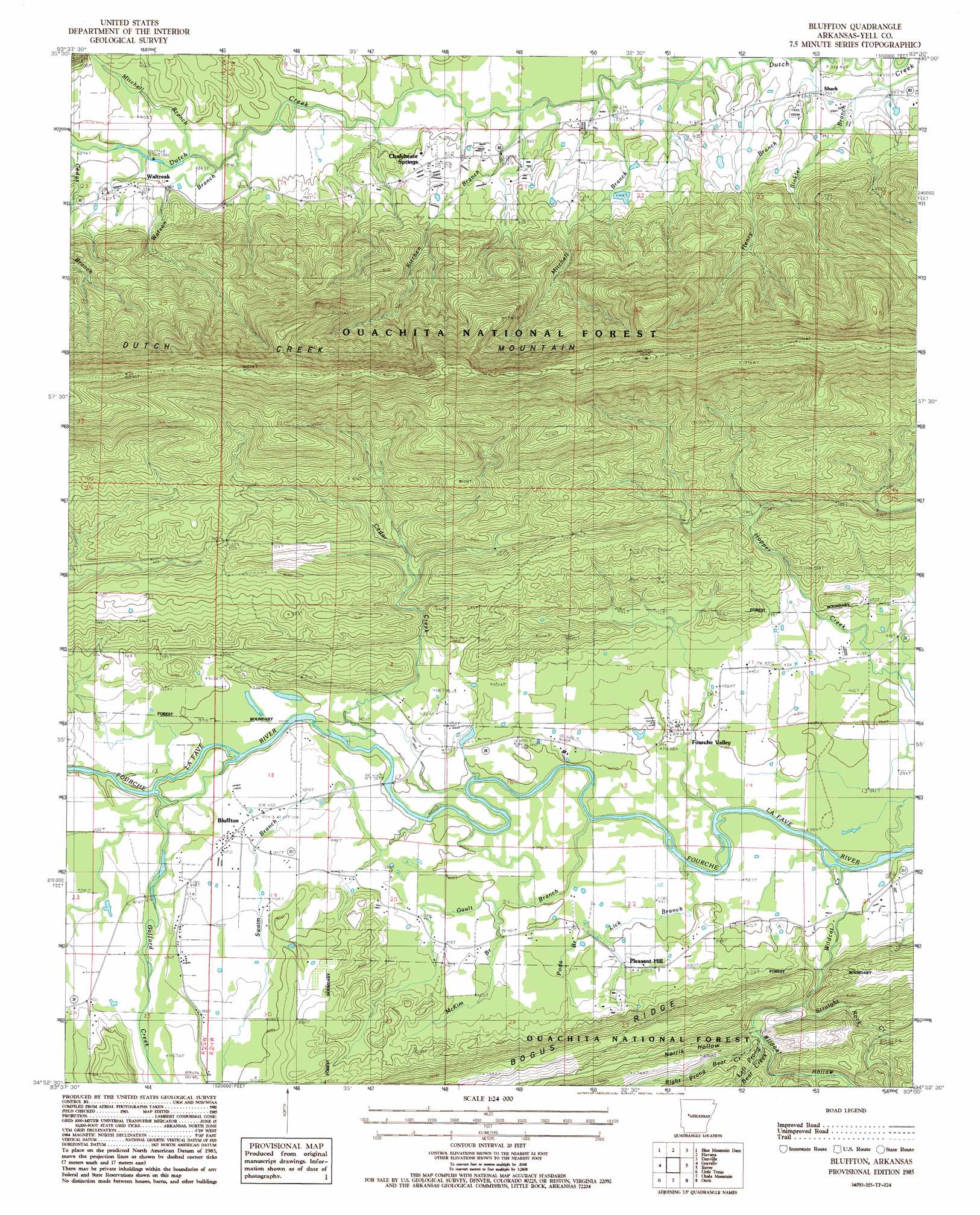
Bluffton Topo Map Arkansas
To zoom in, hover over the map of Bluffton
USGS Topo Quad 34093h5 - 1:24,000 scale
| Topo Map Name: | Bluffton |
| USGS Topo Quad ID: | 34093h5 |
| Print Size: | ca. 21 1/4" wide x 27" high |
| Southeast Coordinates: | 34.875° N latitude / 93.5° W longitude |
| Map Center Coordinates: | 34.9375° N latitude / 93.5625° W longitude |
| U.S. State: | AR |
| Filename: | o34093h5.jpg |
| Download Map JPG Image: | Bluffton topo map 1:24,000 scale |
| Map Type: | Topographic |
| Topo Series: | 7.5´ |
| Map Scale: | 1:24,000 |
| Source of Map Images: | United States Geological Survey (USGS) |
| Alternate Map Versions: |
Bluffton AR 1985, updated 1986 Download PDF Buy paper map Bluffton AR 2011 Download PDF Buy paper map Bluffton AR 2014 Download PDF Buy paper map |
| FStopo: | US Forest Service topo Bluffton is available: Download FStopo PDF Download FStopo TIF |
1:24,000 Topo Quads surrounding Bluffton
Magazine |
Blue Mountain |
Magazine Mountain Ne |
Chickalah Mountain West |
Chickalah Mountain East |
Sugar Grove |
Blue Mountain Dam |
Havana |
Danville |
Danville Mountain |
Freedom Mountain |
Gravelly |
Bluffton |
Rover |
Plainview |
Harvey |
Little Texas |
Chula Mountain |
Onyx |
Steve |
Bushy Creek Mountain |
Sims |
Story |
Fannie |
Avant |
> Back to 34093e1 at 1:100,000 scale
> Back to 34092a1 at 1:250,000 scale
> Back to U.S. Topo Maps home
Bluffton topo map: Gazetteer
Bluffton: Crossings
Briggs Ford elevation 122m 400′Gault Ford elevation 104m 341′
Bluffton: Populated Places
Bluffton elevation 134m 439′Chalybeate Springs elevation 134m 439′
Fourche Valley elevation 122m 400′
Pleasant Hill elevation 132m 433′
Shark elevation 121m 396′
Waltreak elevation 123m 403′
Bluffton: Post Offices
Bluffton Post Office elevation 133m 436′Bluffton: Ridges
Pea Ridge elevation 166m 544′Bluffton: Streams
Bear Creek elevation 116m 380′Cedar Creek elevation 125m 410′
Gafford Creek elevation 127m 416′
Gault Branch elevation 119m 390′
Henry Branch elevation 109m 357′
Hopper Creek elevation 121m 396′
Kitchen Branch elevation 110m 360′
Left Prong Bear Creek elevation 146m 479′
Lick Branch elevation 122m 400′
McClain Branch elevation 124m 406′
McKim Branch elevation 123m 403′
Mitchell Branch elevation 115m 377′
Mitchell Branch elevation 108m 354′
Poda Branch elevation 127m 416′
Right Prong Bear Creek elevation 145m 475′
Straight Rock Creek elevation 149m 488′
Swaim Branch elevation 121m 396′
Watson Branch elevation 115m 377′
Wildcat Creek elevation 119m 390′
Wildcat Creek elevation 116m 380′
Bluffton: Valleys
Norris Hollow elevation 172m 564′Wildcat Hollow elevation 129m 423′
Bluffton digital topo map on disk
Buy this Bluffton topo map showing relief, roads, GPS coordinates and other geographical features, as a high-resolution digital map file on DVD: