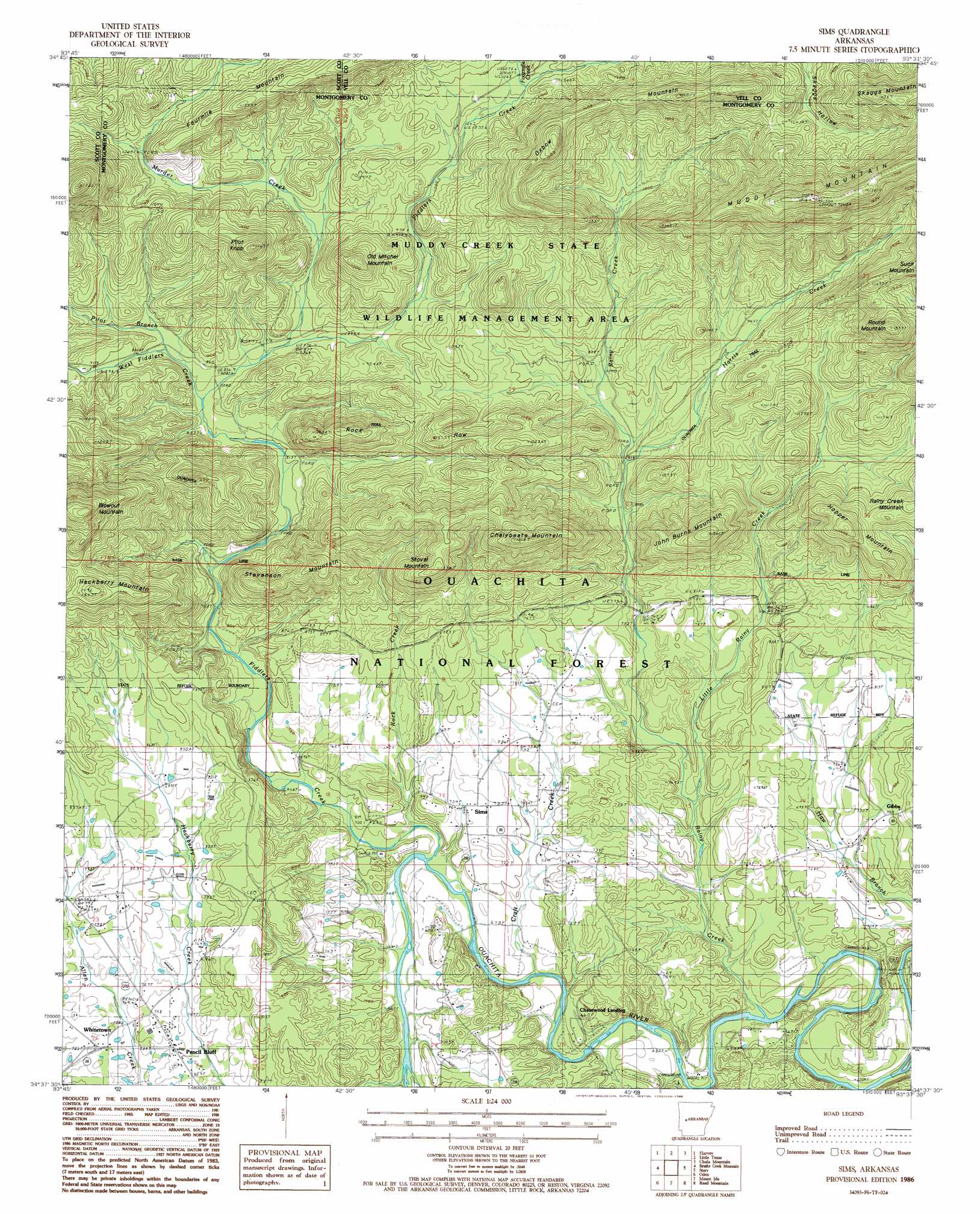
Sims Topo Map Arkansas
To zoom in, hover over the map of Sims
USGS Topo Quad 34093f6 - 1:24,000 scale
| Topo Map Name: | Sims |
| USGS Topo Quad ID: | 34093f6 |
| Print Size: | ca. 21 1/4" wide x 27" high |
| Southeast Coordinates: | 34.625° N latitude / 93.625° W longitude |
| Map Center Coordinates: | 34.6875° N latitude / 93.6875° W longitude |
| U.S. State: | AR |
| Filename: | o34093f6.jpg |
| Download Map JPG Image: | Sims topo map 1:24,000 scale |
| Map Type: | Topographic |
| Topo Series: | 7.5´ |
| Map Scale: | 1:24,000 |
| Source of Map Images: | United States Geological Survey (USGS) |
| Alternate Map Versions: |
Sims AR 1986, updated 1986 Download PDF Buy paper map Sims AR 2011 Download PDF Buy paper map Sims AR 2014 Download PDF Buy paper map |
| FStopo: | US Forest Service topo Sims is available: Download FStopo PDF Download FStopo TIF |
1:24,000 Topo Quads surrounding Sims
Bee Mountain |
Freedom Mountain |
Gravelly |
Bluffton |
Rover |
Parks |
Harvey |
Little Texas |
Chula Mountain |
Onyx |
Buck Knob |
Bushy Creek Mountain |
Sims |
Story |
Fannie |
Pine Ridge |
Oden |
Mount Ida |
Reed Mountain |
Mcgraw Mountain |
Big Fork |
Polk Creek Mountain |
Norman |
Caddo Gap |
Bonnerdale |
> Back to 34093e1 at 1:100,000 scale
> Back to 34092a1 at 1:250,000 scale
> Back to U.S. Topo Maps home
Sims topo map: Gazetteer
Sims: Airports
Chasewood Landing elevation 207m 679′Sims: Parks
Dragover Recreation Area elevation 215m 705′Fulton Branch Recreation Area elevation 204m 669′
River Bluff Recreation Area elevation 186m 610′
Sims: Populated Places
Chasewood Landing elevation 203m 666′Pencil Bluff elevation 228m 748′
Sims elevation 222m 728′
Whitetown elevation 234m 767′
Sims: Post Offices
Pencil Bluff Post Office elevation 227m 744′Sims Post Office elevation 221m 725′
Sims: Ridges
Oxbow Mountain elevation 425m 1394′Rock Row elevation 367m 1204′
Sims: Streams
Craft Creek elevation 193m 633′Fiddlers Creek elevation 198m 649′
Fourmile Creek elevation 326m 1069′
Fulton Branch elevation 192m 629′
Hackberry Creek elevation 199m 652′
Harris Creek elevation 243m 797′
Little Rainy Creek elevation 203m 666′
Murder Creek elevation 263m 862′
Pilot Branch elevation 262m 859′
Rainy Creek elevation 190m 623′
Rock Creek elevation 201m 659′
West Fiddlers Creek elevation 254m 833′
Sims: Summits
Blowout Mountain elevation 519m 1702′Chalybeate Mountain elevation 458m 1502′
Hackberry Mountain elevation 434m 1423′
Hopper Mountain elevation 414m 1358′
John Burns Mountain elevation 402m 1318′
Old Mitchel Mountain elevation 420m 1377′
Pilot Knob elevation 443m 1453′
Round Mountain elevation 466m 1528′
Skaggs Mountain elevation 505m 1656′
Stevenson Mountain elevation 391m 1282′
Stovall Mountain elevation 405m 1328′
Sims digital topo map on disk
Buy this Sims topo map showing relief, roads, GPS coordinates and other geographical features, as a high-resolution digital map file on DVD: