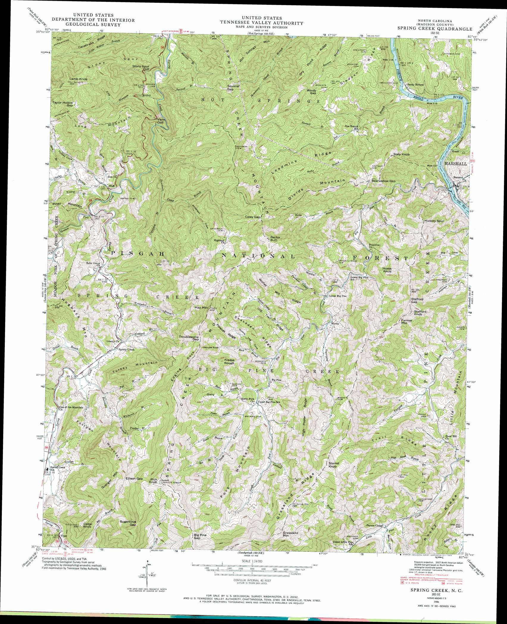
Spring Creek Topo Map North Carolina
To zoom in, hover over the map of Spring Creek
USGS Topo Quad 35082g7 - 1:24,000 scale
| Topo Map Name: | Spring Creek |
| USGS Topo Quad ID: | 35082g7 |
| Print Size: | ca. 21 1/4" wide x 27" high |
| Southeast Coordinates: | 35.75° N latitude / 82.75° W longitude |
| Map Center Coordinates: | 35.8125° N latitude / 82.8125° W longitude |
| U.S. State: | NC |
| Filename: | o35082g7.jpg |
| Download Map JPG Image: | Spring Creek topo map 1:24,000 scale |
| Map Type: | Topographic |
| Topo Series: | 7.5´ |
| Map Scale: | 1:24,000 |
| Source of Map Images: | United States Geological Survey (USGS) |
| Alternate Map Versions: |
Spring Creek NC 1935 Download PDF Buy paper map Spring Creek NC 1946, updated 1957 Download PDF Buy paper map Spring Creek NC 1946, updated 1970 Download PDF Buy paper map Spring Creek NC 1946, updated 1970 Download PDF Buy paper map Spring Creek NC 1947, updated 1947 Download PDF Buy paper map Spring Creek NC 2011 Download PDF Buy paper map Spring Creek NC 2013 Download PDF Buy paper map Spring Creek NC 2016 Download PDF Buy paper map |
| FStopo: | US Forest Service topo Spring Creek is available: Download FStopo PDF Download FStopo TIF |
1:24,000 Topo Quads surrounding Spring Creek
Parrotsville |
Cedar Creek |
Davy Crockett Lake |
Greystone |
Flag Pond |
Neddy Mountain |
Paint Rock |
Hot Springs |
White Rock |
Sams Gap |
Waterville |
Lemon Gap |
Spring Creek |
Marshall |
Mars Hill |
Cove Creek Gap |
Fines Creek |
Sandymush |
Leicester |
Weaverville |
Dellwood |
Clyde |
Canton |
Enka |
Asheville |
> Back to 35082e1 at 1:100,000 scale
> Back to 35082a1 at 1:250,000 scale
> Back to U.S. Topo Maps home
Spring Creek topo map: Gazetteer
Spring Creek: Cliffs
Stony Spur Cliff elevation 604m 1981′Vann Cliff elevation 616m 2020′
Spring Creek: Gaps
Bearwallow Gap elevation 697m 2286′Big Pine Gap elevation 1185m 3887′
Coley Gap elevation 954m 3129′
Ellison Gap elevation 1090m 3576′
Squirrel Gap elevation 718m 2355′
Stafford Gap elevation 860m 2821′
Sugar Cove Gap elevation 1140m 3740′
Taylor Hollow Gap elevation 810m 2657′
Troublesome Gap elevation 1083m 3553′
Windy Gap elevation 695m 2280′
Spring Creek: Pillars
House Rock elevation 1090m 3576′Spring Creek: Populated Places
Barnard elevation 468m 1535′Big Pine elevation 724m 2375′
Bluff elevation 577m 1893′
Sandy Bottom elevation 447m 1466′
Spring Creek elevation 641m 2103′
Trust elevation 736m 2414′
Worley elevation 651m 2135′
Spring Creek: Post Offices
Barnard's Station Post Office elevation 468m 1535′Spring Creek: Ranges
Spring Creek Mountain elevation 1229m 4032′Spring Creek: Ridges
Canebrake Ridge elevation 765m 2509′Dry Pond Ridge elevation 736m 2414′
Edging Rock elevation 1164m 3818′
Gladden Ridge elevation 669m 2194′
Grassland Ridge elevation 1128m 3700′
Hickory Spur elevation 812m 2664′
High Poplar Ridge elevation 1119m 3671′
Leadmine Ridge elevation 718m 2355′
Old Trail Ridge elevation 847m 2778′
Polecat Ridge elevation 1000m 3280′
Rocky Ridge elevation 834m 2736′
Snakeden Ridge elevation 936m 3070′
Stony Spur elevation 809m 2654′
Trail Ridge elevation 876m 2874′
Worley Mill Ridge elevation 945m 3100′
Spring Creek: Streams
Back Branch elevation 709m 2326′Baker Branch elevation 749m 2457′
Baltimore Branch elevation 650m 2132′
Beck Branch elevation 617m 2024′
Bee Branch elevation 839m 2752′
Big Pine Creek elevation 461m 1512′
Brush Creek elevation 457m 1499′
Caldwell Branch elevation 817m 2680′
Caldwell Branch elevation 643m 2109′
Charley Branch elevation 569m 1866′
Charlotte Branch elevation 688m 2257′
Coonpatch Branch elevation 585m 1919′
Davis Branch elevation 797m 2614′
Doe Branch elevation 440m 1443′
Fall Branch elevation 687m 2253′
Friezeland Creek elevation 738m 2421′
Gentry Branch elevation 839m 2752′
Georgia Branch elevation 667m 2188′
Granger Branch elevation 687m 2253′
Greasy Branch elevation 648m 2125′
High Shoal Branch elevation 567m 1860′
Hogskin Branch elevation 615m 2017′
Indian Camp Branch elevation 688m 2257′
Levi Branch elevation 525m 1722′
Long Mountain Branch elevation 473m 1551′
Meadow Fork elevation 569m 1866′
Mountain Island Branch elevation 412m 1351′
North Fork Big Pine Creek elevation 753m 2470′
Panther Branch elevation 838m 2749′
Peace Branch elevation 772m 2532′
Puncheon Camp Branch elevation 630m 2066′
Puncheon Camp Branch elevation 525m 1722′
Raccoon Branch elevation 443m 1453′
Rector Branch elevation 534m 1751′
Rocky Branch elevation 577m 1893′
Rough Branch elevation 640m 2099′
Sawmill Branch elevation 580m 1902′
South Fork Big Pine Creek elevation 756m 2480′
Squirrel Branch elevation 467m 1532′
Steve Branch elevation 553m 1814′
Sugarcamp Branch elevation 653m 2142′
Whiterock Branch elevation 750m 2460′
Wildcat Branch elevation 569m 1866′
Wooleyshot Branch elevation 629m 2063′
Spring Creek: Summits
Cedar Knob elevation 1031m 3382′Divide Mountain elevation 847m 2778′
Farmer Mountain elevation 936m 3070′
Fork Mountain elevation 1094m 3589′
Foxtown Mountain elevation 1120m 3674′
Fradys Rough elevation 1043m 3421′
Granger Mountain elevation 1130m 3707′
Grassland Mountain elevation 1250m 4101′
Hap Mountain elevation 1229m 4032′
Horse Knob elevation 859m 2818′
Hot Springs Mountain elevation 767m 2516′
Lamb Knob elevation 975m 3198′
Little Mountain elevation 838m 2749′
Long Mountain elevation 952m 3123′
Piney Mountain elevation 789m 2588′
Rector Butt elevation 1079m 3540′
Rich Knob elevation 1301m 4268′
Slaty Knob elevation 857m 2811′
Spring Creek Mountain elevation 994m 3261′
Stafford Knob elevation 938m 3077′
Starret Knob elevation 1262m 4140′
Turkey Mountain elevation 970m 3182′
Spring Creek: Valleys
Anderson Cove elevation 651m 2135′Barns Cove elevation 620m 2034′
Elbow Hollow elevation 450m 1476′
Hollow Log Cove elevation 777m 2549′
Turkey Cove elevation 620m 2034′
Spring Creek digital topo map on disk
Buy this Spring Creek topo map showing relief, roads, GPS coordinates and other geographical features, as a high-resolution digital map file on DVD:
South Carolina, Western North Carolina & Northeastern Georgia
Buy digital topo maps: South Carolina, Western North Carolina & Northeastern Georgia