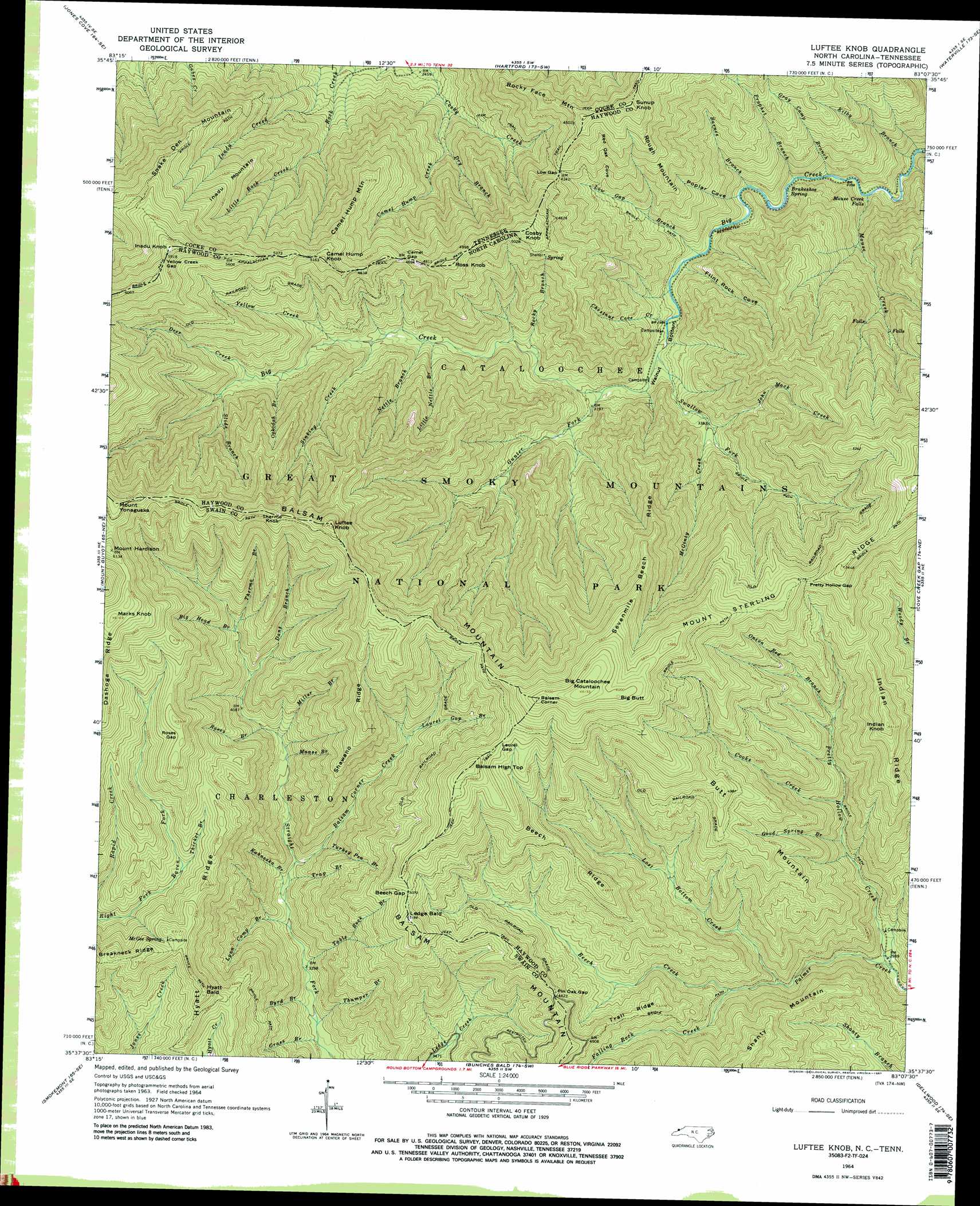
Luftee Knob Topo Map North Carolina
To zoom in, hover over the map of Luftee Knob
USGS Topo Quad 35083f2 - 1:24,000 scale
| Topo Map Name: | Luftee Knob |
| USGS Topo Quad ID: | 35083f2 |
| Print Size: | ca. 21 1/4" wide x 27" high |
| Southeast Coordinates: | 35.625° N latitude / 83.125° W longitude |
| Map Center Coordinates: | 35.6875° N latitude / 83.1875° W longitude |
| U.S. States: | NC, TN |
| Filename: | o35083f2.jpg |
| Download Map JPG Image: | Luftee Knob topo map 1:24,000 scale |
| Map Type: | Topographic |
| Topo Series: | 7.5´ |
| Map Scale: | 1:24,000 |
| Source of Map Images: | United States Geological Survey (USGS) |
| Alternate Map Versions: |
Luftee Knob NC 1964, updated 1967 Download PDF Buy paper map Luftee Knob NC 1964, updated 1974 Download PDF Buy paper map Luftee Knob NC 1964, updated 1987 Download PDF Buy paper map Luftee Knob NC 1964, updated 1987 Download PDF Buy paper map Luftee Knob NC 1976, updated 1979 Download PDF Buy paper map Luftee Knob NC 2000, updated 2001 Download PDF Buy paper map Luftee Knob NC 2010 Download PDF Buy paper map Luftee Knob NC 2013 Download PDF Buy paper map Luftee Knob NC 2016 Download PDF Buy paper map |
1:24,000 Topo Quads surrounding Luftee Knob
Shady Grove |
Chestnut Hill |
Newport |
Neddy Mountain |
Paint Rock |
Richardson Cove |
Jones Cove |
Hartford |
Waterville |
Lemon Gap |
Mount Le Conte |
Mount Guyot |
Luftee Knob |
Cove Creek Gap |
Fines Creek |
Clingmans Dome |
Smokemont |
Bunches Bald |
Dellwood |
Clyde |
Bryson City |
Whittier |
Sylva North |
Hazelwood |
Waynesville |
> Back to 35083e1 at 1:100,000 scale
> Back to 35082a1 at 1:250,000 scale
> Back to U.S. Topo Maps home
Luftee Knob topo map: Gazetteer
Luftee Knob: Falls
Mouse Creek Falls elevation 733m 2404′Luftee Knob: Gaps
Beech Gap elevation 1545m 5068′Camel Gap elevation 1432m 4698′
Camel Gap elevation 1444m 4737′
Deer Creek Gap elevation 1711m 5613′
Laurel Gap elevation 1659m 5442′
Low Gap elevation 1271m 4169′
Pin Oak Gap elevation 1349m 4425′
Pretty Hollow Gap elevation 1579m 5180′
Roses Gap elevation 1659m 5442′
Yellow Creek Gap elevation 1795m 5889′
Yellow Creek Gap elevation 1795m 5889′
Luftee Knob: Ridges
Beech Ridge elevation 1446m 4744′Breakneck Ridge elevation 1568m 5144′
Butt Mountain elevation 1511m 4957′
Dasohga Ridge elevation 1758m 5767′
Hyatt Ridge elevation 1467m 4812′
Indian Ridge elevation 1552m 5091′
Mount Sterling Ridge elevation 1730m 5675′
Sevenmile Beech Ridge elevation 1610m 5282′
Shawano Ridge elevation 1619m 5311′
Trail Ridge elevation 1297m 4255′
Luftee Knob: Springs
Brakeshoe Spring elevation 781m 2562′Mc Gee Spring elevation 1537m 5042′
Luftee Knob: Streams
Balsam Corner Creek elevation 1091m 3579′Barnes Branch elevation 845m 2772′
Beech Creek elevation 1057m 3467′
Bettis Branch elevation 635m 2083′
Big Head Branch elevation 1348m 4422′
Byrd Branch elevation 972m 3188′
Camel Hump Creek elevation 829m 2719′
Chestnut Cove Creek elevation 908m 2979′
Cooks Creek elevation 1112m 3648′
Dans Branch elevation 1288m 4225′
Deer Creek elevation 1297m 4255′
Dry Branch elevation 831m 2726′
Falling Rock Creek elevation 1054m 3458′
Good Spring Branch elevation 1066m 3497′
Grass Branch elevation 965m 3166′
Gray Camp Branch elevation 733m 2404′
Gunter Fork elevation 963m 3159′
Inadu Creek elevation 822m 2696′
John Mack Creek elevation 1045m 3428′
Kahneska Branch elevation 1055m 3461′
Kilby Branch elevation 631m 2070′
Laurel Gap Branch elevation 1366m 4481′
Little Nettle Branch elevation 1097m 3599′
Little Rock Creek elevation 970m 3182′
Lost Bottom Creek elevation 1013m 3323′
Low Gap Branch elevation 866m 2841′
Lynn Camp Branch elevation 1038m 3405′
Manse Branch elevation 1184m 3884′
Mc Ginty Creek elevation 1028m 3372′
Miller Branch elevation 1218m 3996′
Mouse Creek elevation 693m 2273′
Nettle Branch elevation 1102m 3615′
Onion Bed Branch elevation 1226m 4022′
Oskodah Branch elevation 1268m 4160′
Pretty Hollow Creek elevation 907m 2975′
Prophet Branch elevation 779m 2555′
Rocky Branch elevation 1048m 3438′
Roses Branch elevation 1216m 3989′
Sinking Creek elevation 1151m 3776′
Slide Branch elevation 1321m 4333′
Swallow Fork elevation 924m 3031′
Table Rock Branch elevation 1001m 3284′
Thermo Branch elevation 1348m 4422′
Thicket Branch elevation 1408m 4619′
Thumper Branch elevation 972m 3188′
Trap Branch elevation 1088m 3569′
Turkey Pen Branch elevation 1143m 3750′
Yellow Creek elevation 1192m 3910′
Luftee Knob: Summits
Balsam Corner elevation 1837m 6026′Balsam High Top elevation 1738m 5702′
Big Butt elevation 1837m 6026′
Big Cataloochee Mountain elevation 1844m 6049′
Camel Hump Knob elevation 1571m 5154′
Camel Hump Knob elevation 1593m 5226′
Camel Hump Mountain elevation 1394m 4573′
Cosby Knob elevation 1554m 5098′
Cosby Knob elevation 1571m 5154′
Hyatt Bald elevation 1564m 5131′
Inadu Knob elevation 1811m 5941′
Inadu Knob elevation 1797m 5895′
Inadu Mountain elevation 1564m 5131′
Indian Knob elevation 1562m 5124′
Ledge Bald elevation 1580m 5183′
Luftee Knob elevation 1841m 6040′
Marks Knob elevation 1863m 6112′
Mount Hardison elevation 1871m 6138′
Mount Yonaguska elevation 1868m 6128′
Rocky Face Mountain elevation 1416m 4645′
Ross Knob elevation 1545m 5068′
Ross Knob elevation 1542m 5059′
Rough Mountain elevation 1341m 4399′
Snake Den Mountain elevation 1572m 5157′
Sunup Knob elevation 1533m 5029′
Sunup Knob elevation 1533m 5029′
Thermo Knob elevation 1853m 6079′
Luftee Knob: Valleys
Flint Rock Cove elevation 874m 2867′Poplar Cove elevation 845m 2772′
Red Oak Cove elevation 1131m 3710′
Walnut Bottom elevation 895m 2936′
Luftee Knob digital topo map on disk
Buy this Luftee Knob topo map showing relief, roads, GPS coordinates and other geographical features, as a high-resolution digital map file on DVD:
South Carolina, Western North Carolina & Northeastern Georgia
Buy digital topo maps: South Carolina, Western North Carolina & Northeastern Georgia