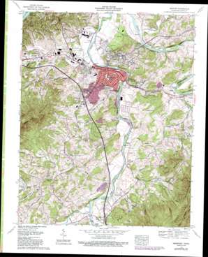
Newport Topo Map Tennessee
To zoom in, hover over the map of Newport
USGS Topo Quad 35083h2 - 1:24,000 scale
| Topo Map Name: | Newport |
| USGS Topo Quad ID: | 35083h2 |
| Print Size: | ca. 21 1/4" wide x 27" high |
| Southeast Coordinates: | 35.875° N latitude / 83.125° W longitude |
| Map Center Coordinates: | 35.9375° N latitude / 83.1875° W longitude |
| U.S. State: | TN |
| Filename: | o35083h2.jpg |
| Download Map JPG Image: | Newport topo map 1:24,000 scale |
| Map Type: | Topographic |
| Topo Series: | 7.5´ |
| Map Scale: | 1:24,000 |
| Source of Map Images: | United States Geological Survey (USGS) |
| Alternate Map Versions: |
Newport TN 1940 Download PDF Buy paper map Newport TN 1940, updated 1959 Download PDF Buy paper map Newport TN 1961, updated 1965 Download PDF Buy paper map Newport TN 1961, updated 1976 Download PDF Buy paper map Newport TN 1961, updated 1993 Download PDF Buy paper map Newport TN 2011 Download PDF Buy paper map Newport TN 2013 Download PDF Buy paper map Newport TN 2016 Download PDF Buy paper map |
| FStopo: | US Forest Service topo Newport is available: Download FStopo PDF Download FStopo TIF |
1:24,000 Topo Quads surrounding Newport
> Back to 35083e1 at 1:100,000 scale
> Back to 35082a1 at 1:250,000 scale
> Back to U.S. Topo Maps home
Newport topo map: Gazetteer
Newport: Bridges
John W Fisher Bridge elevation 319m 1046′McSween Memorial Bridge elevation 316m 1036′
Newport: Crossings
Interchange 435 elevation 386m 1266′Interchange 440 elevation 366m 1200′
Newport: Gaps
Low Gap elevation 748m 2454′Newport: Islands
Boyer Island elevation 311m 1020′Sisk Island elevation 329m 1079′
Susong Island elevation 317m 1040′
Tannery Island elevation 319m 1046′
Vinson Island elevation 338m 1108′
Newport: Lakes
Crawley Pond elevation 357m 1171′Newport: Populated Places
Bat Harbor elevation 365m 1197′Castle Heights elevation 358m 1174′
Eastport elevation 324m 1062′
Edwina elevation 331m 1085′
English Creek elevation 376m 1233′
Gum Spring elevation 364m 1194′
Irish Cut elevation 353m 1158′
Jaybird elevation 335m 1099′
Jimtown elevation 374m 1227′
Newport elevation 321m 1053′
Northport elevation 359m 1177′
Oldtown elevation 317m 1040′
Pleasant Grove elevation 358m 1174′
West End elevation 334m 1095′
Wilsonville elevation 354m 1161′
Wilton Springs elevation 364m 1194′
Newport: Post Offices
Newport Post Office elevation 322m 1056′Newport: Springs
Burnett Spring elevation 333m 1092′McSween Spring elevation 359m 1177′
Newport: Streams
Allen Branch elevation 316m 1036′Breeden Branch elevation 361m 1184′
Cameron Branch elevation 358m 1174′
Clear Creek elevation 309m 1013′
Coldspring Branch elevation 373m 1223′
Cosby Creek elevation 340m 1115′
English Creek elevation 322m 1056′
Fine Branch elevation 335m 1099′
Halltop Branch elevation 358m 1174′
Ike Wright Branch elevation 331m 1085′
Kyker Branch elevation 357m 1171′
Laurel Branch elevation 354m 1161′
McMahan Branch elevation 340m 1115′
Morell Springs Branch elevation 326m 1069′
Murray Branch elevation 317m 1040′
O'Neil Branch elevation 328m 1076′
Pheasant Branch elevation 344m 1128′
Sinking Creek elevation 316m 1036′
Sweetwater Creek elevation 329m 1079′
Whitesprings Branch elevation 477m 1564′
Yellow Springs Branch elevation 370m 1213′
Newport: Summits
Piney Mountain elevation 657m 2155′Newport: Valleys
Bear Wallow Hollow elevation 378m 1240′Britt Hollow elevation 364m 1194′
Chicken Hollow elevation 359m 1177′
Crumb Hollow elevation 431m 1414′
Goose Hollow elevation 333m 1092′
Sheep Hollow elevation 367m 1204′
Trantham Hollow elevation 339m 1112′
Newport digital topo map on disk
Buy this Newport topo map showing relief, roads, GPS coordinates and other geographical features, as a high-resolution digital map file on DVD:
South Carolina, Western North Carolina & Northeastern Georgia
Buy digital topo maps: South Carolina, Western North Carolina & Northeastern Georgia


