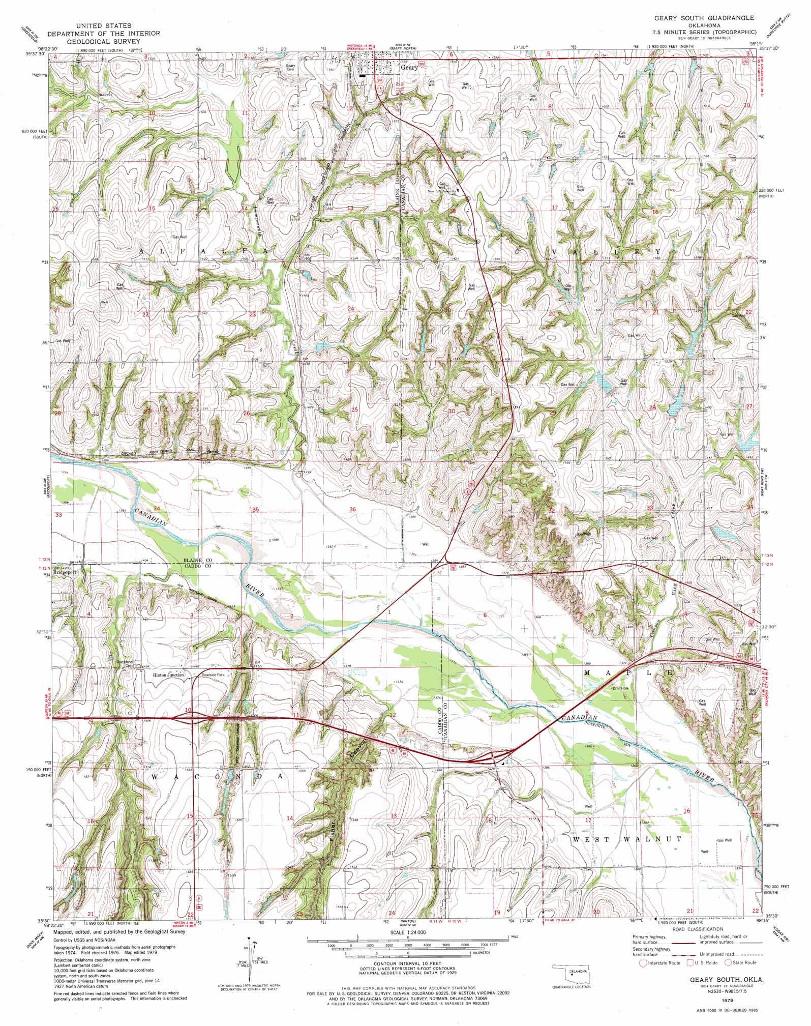
Geary South Topo Map Oklahoma
To zoom in, hover over the map of Geary South
USGS Topo Quad 35098e3 - 1:24,000 scale
| Topo Map Name: | Geary South |
| USGS Topo Quad ID: | 35098e3 |
| Print Size: | ca. 21 1/4" wide x 27" high |
| Southeast Coordinates: | 35.5° N latitude / 98.25° W longitude |
| Map Center Coordinates: | 35.5625° N latitude / 98.3125° W longitude |
| U.S. State: | OK |
| Filename: | o35098e3.jpg |
| Download Map JPG Image: | Geary South topo map 1:24,000 scale |
| Map Type: | Topographic |
| Topo Series: | 7.5´ |
| Map Scale: | 1:24,000 |
| Source of Map Images: | United States Geological Survey (USGS) |
| Alternate Map Versions: |
Geary South OK 1979, updated 1979 Download PDF Buy paper map Geary South OK 2010 Download PDF Buy paper map Geary South OK 2012 Download PDF Buy paper map Geary South OK 2016 Download PDF Buy paper map |
1:24,000 Topo Quads surrounding Geary South
Oakwood Se |
Watonga |
Watonga Se |
Omega |
Loyal Se |
Squaw Creek |
Greenfield |
Geary North |
Porcupine Butte |
Fort Reno Ne |
Hydro |
Bridgeport |
Geary South |
Fort Reno Sw |
Fort Reno |
Eakly Ne |
Rock Mary |
Hinton |
Cogar Nw |
Cogar Ne |
Eakly |
Sickles |
Binger |
Cogar |
Cogar Se |
> Back to 35098e1 at 1:100,000 scale
> Back to 35098a1 at 1:250,000 scale
> Back to U.S. Topo Maps home
Geary South topo map: Gazetteer
Geary South: Dams
Canyon View Site 1 Dam elevation 448m 1469′Canyon View Site 2 Dam elevation 443m 1453′
Canyon View Site 3 Dam elevation 440m 1443′
Canyon View Site 4 Dam elevation 443m 1453′
Garland Brooks Dam elevation 460m 1509′
John Shawyer Dam elevation 444m 1456′
Geary South: Reservoirs
Canyon View Site 1 Reservoir elevation 448m 1469′Canyon View Site 2 Reservoir elevation 443m 1453′
Canyon View Site 3 Reservoir elevation 440m 1443′
Canyon View Site 4 Reservoir elevation 443m 1453′
Garland Brooks Reservoir elevation 460m 1509′
John Shawyer Reservoir elevation 444m 1456′
Geary South: Streams
Lumpmouth Creek elevation 423m 1387′Geary South: Valleys
Fisher Canyon elevation 421m 1381′Geary South digital topo map on disk
Buy this Geary South topo map showing relief, roads, GPS coordinates and other geographical features, as a high-resolution digital map file on DVD: