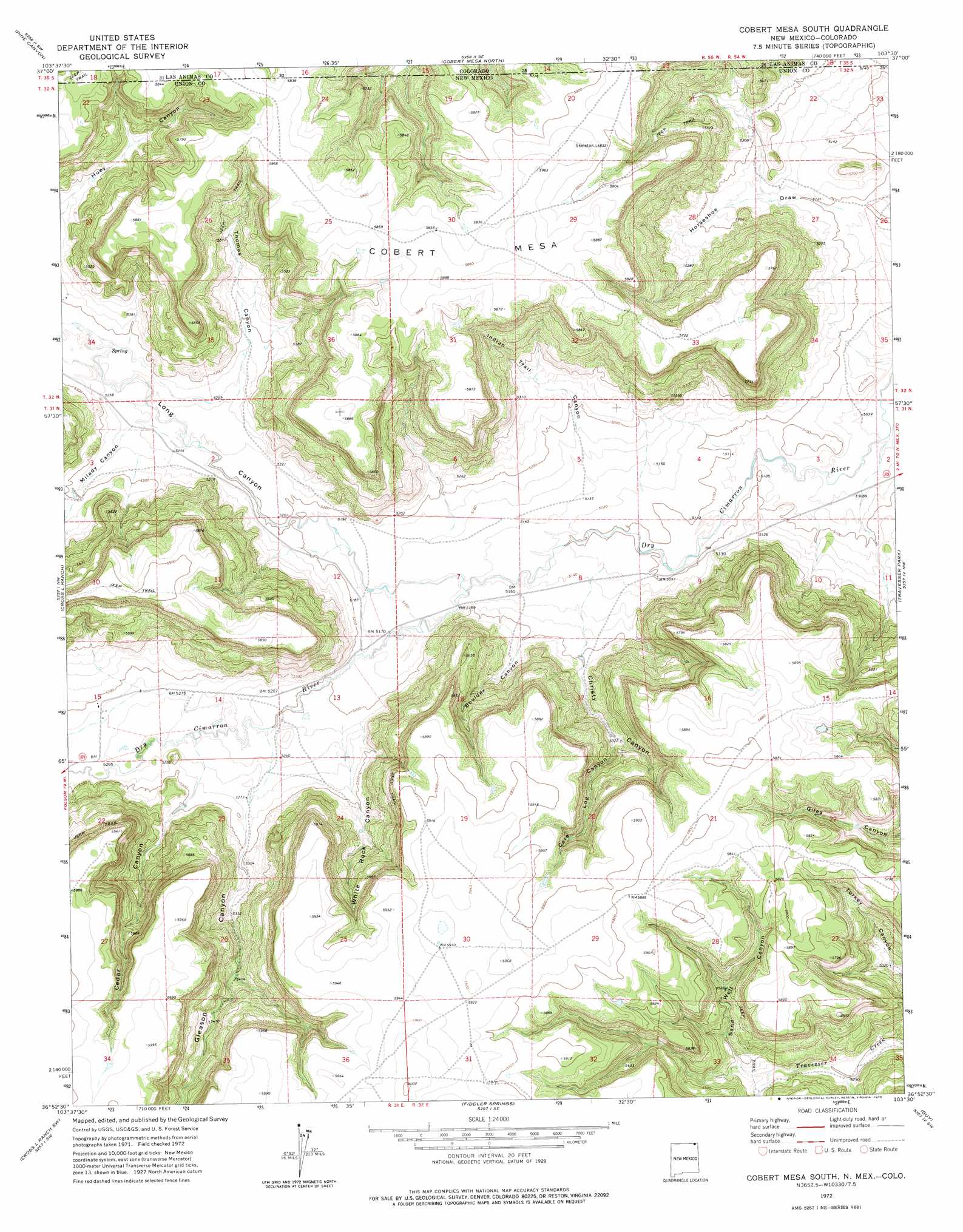
Cobert Mesa South Topo Map New Mexico
To zoom in, hover over the map of Cobert Mesa South
USGS Topo Quad 36103h5 - 1:24,000 scale
| Topo Map Name: | Cobert Mesa South |
| USGS Topo Quad ID: | 36103h5 |
| Print Size: | ca. 21 1/4" wide x 27" high |
| Southeast Coordinates: | 36.875° N latitude / 103.5° W longitude |
| Map Center Coordinates: | 36.9375° N latitude / 103.5625° W longitude |
| U.S. States: | NM, CO |
| Filename: | o36103h5.jpg |
| Download Map JPG Image: | Cobert Mesa South topo map 1:24,000 scale |
| Map Type: | Topographic |
| Topo Series: | 7.5´ |
| Map Scale: | 1:24,000 |
| Source of Map Images: | United States Geological Survey (USGS) |
| Alternate Map Versions: |
Cobert Mesa South NM 1972, updated 1975 Download PDF Buy paper map Cobert Mesa South NM 2010 Download PDF Buy paper map Cobert Mesa South NM 2013 Download PDF Buy paper map Cobert Mesa South NM 2017 Download PDF Buy paper map |
1:24,000 Topo Quads surrounding Cobert Mesa South
Box Ranch |
Miners Peak |
Tobe |
Dalerose Mesa |
Kim South |
Branson Se |
Pine Canyon |
Cobert Mesa North |
Jesus Canyon |
Dennis Canyon |
Emery Peak |
Cross L Ranch |
Cobert Mesa South |
Travesser Park |
Tub Spring |
Des Moines |
Cross L Ranch Sw |
Fiddler Springs |
Guy |
Cuates School |
Little Grande |
Wetherly Lake |
Blind Gap |
Boiler Gap |
Mclaughlin Bridge |
> Back to 36103e1 at 1:100,000 scale
> Back to 36102a1 at 1:250,000 scale
> Back to U.S. Topo Maps home
Cobert Mesa South topo map: Gazetteer
Cobert Mesa South: Mines
Folsom Area elevation 1587m 5206′Cobert Mesa South: Springs
Gleason Springs elevation 1609m 5278′Cobert Mesa South: Summits
Cobert Mesa elevation 1787m 5862′Cobert Mesa South: Valleys
Boulder Canyon elevation 1586m 5203′Cedar Canyon elevation 1608m 5275′
Christy Canyon elevation 1584m 5196′
Core Log Canyon elevation 1619m 5311′
Gleason Canyon elevation 1604m 5262′
Horseshoe Draw elevation 1552m 5091′
Indian Trail Canyon elevation 1579m 5180′
Long Canyon elevation 1568m 5144′
Long Canyon elevation 1568m 5144′
Milady Canyon elevation 1599m 5246′
Sand Well Canyon elevation 1640m 5380′
Thomas Canyon elevation 1602m 5255′
White Rock Canyon elevation 1599m 5246′
Wildcat Canyon elevation 1616m 5301′
Cobert Mesa South digital topo map on disk
Buy this Cobert Mesa South topo map showing relief, roads, GPS coordinates and other geographical features, as a high-resolution digital map file on DVD: