Tancosa Windmill Topo Map New Mexico
To zoom in, hover over the map of Tancosa Windmill
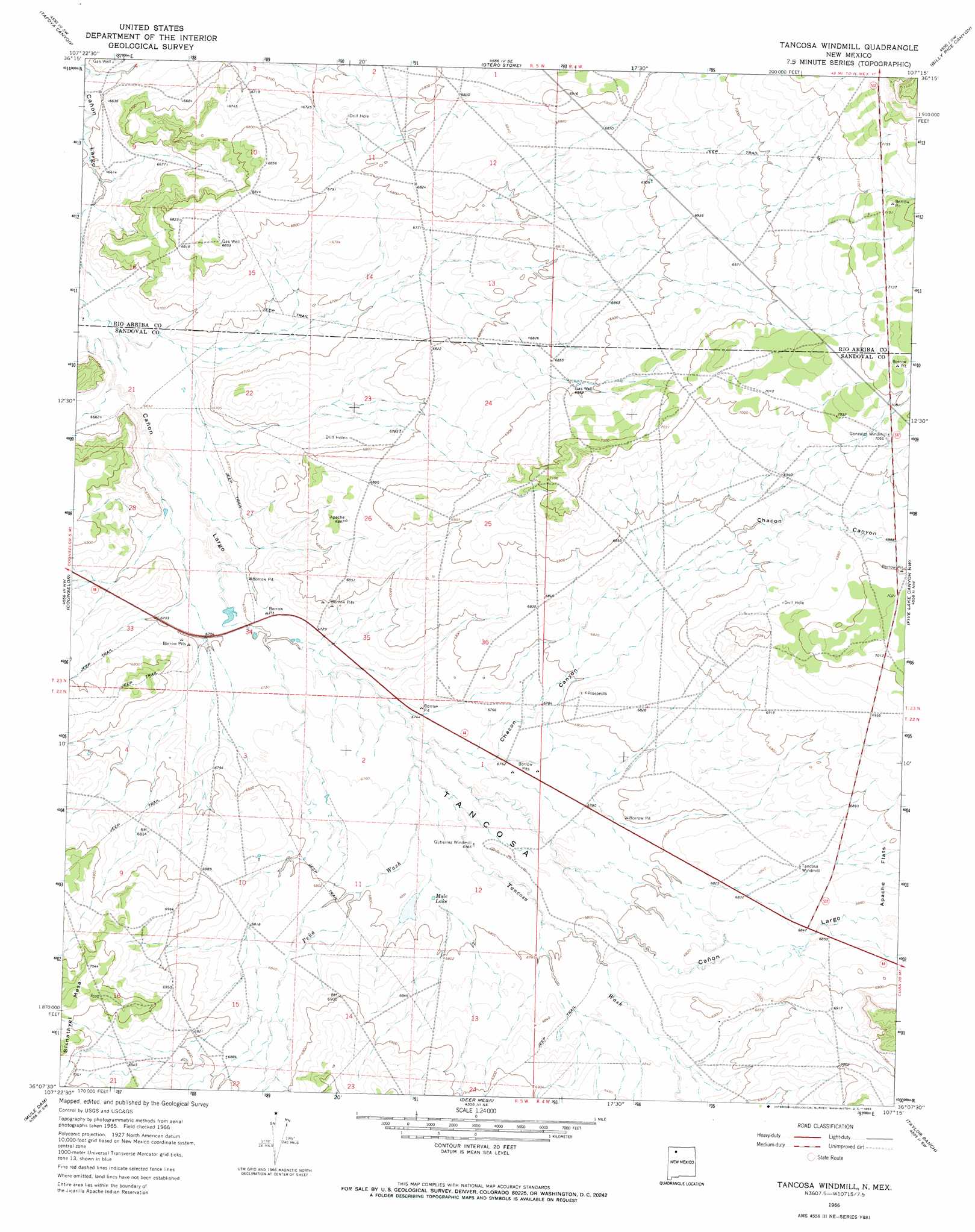
USGS Topo Quad 36107b3 - 1:24,000 scale
| Topo Map Name: | Tancosa Windmill |
| USGS Topo Quad ID: | 36107b3 |
| Print Size: | ca. 21 1/4" wide x 27" high |
| Southeast Coordinates: | 36.125° N latitude / 107.25° W longitude |
| Map Center Coordinates: | 36.1875° N latitude / 107.3125° W longitude |
| U.S. State: | NM |
| Filename: | o36107b3.jpg |
| Download Map JPG Image: | Tancosa Windmill topo map 1:24,000 scale |
| Map Type: | Topographic |
| Topo Series: | 7.5´ |
| Map Scale: | 1:24,000 |
| Source of Map Images: | United States Geological Survey (USGS) |
| Alternate Map Versions: |
Tancosa Windmill NM 1966, updated 1969 Download PDF Buy paper map Tancosa Windmill NM 2010 Download PDF Buy paper map Tancosa Windmill NM 2013 Download PDF Buy paper map Tancosa Windmill NM 2017 Download PDF Buy paper map |
1:24,000 Topo Quads surrounding Tancosa Windmill
Smouse Mesa |
Gonzales Mesa |
Lapis Point |
Schmitz Ranch |
Ojito |
Crow Mesa East |
Tafoya Canyon |
Otero Store |
Billy Rice Canyon |
Lindrith |
Lybrook |
Counselor |
Tancosa Windmill |
Five Lakes Canyon Nw |
Five Lakes Canyon Ne |
Lybrook Se |
Mule Dam |
Deer Mesa |
Taylor Ranch |
Arroyo Chijuillita |
Pueblo Alto Trading Post |
Star Lake |
Ojo Encino Mesa |
Johnson Trading Post |
Mesa Portales |
> Back to 36107a1 at 1:100,000 scale
> Back to 36106a1 at 1:250,000 scale
> Back to U.S. Topo Maps home
Tancosa Windmill topo map: Gazetteer
Tancosa Windmill: Areas
Tancosa elevation 2062m 6765′Tancosa Windmill: Flats
Apache Flats elevation 2097m 6879′Tancosa Windmill: Lakes
Mule Lake elevation 2066m 6778′Tancosa Windmill: Mines
Borrow Pit elevation 2061m 6761′Borrow Pit elevation 2182m 7158′
Borrow Pit elevation 2074m 6804′
Borrow Pit elevation 2134m 7001′
Borrow Pits elevation 2062m 6765′
Borrow Pits elevation 2071m 6794′
Borrow Pits elevation 2048m 6719′
Jicarilla Apache Deposit elevation 2104m 6902′
Tancosa Windmill: Streams
Peña Wash elevation 2055m 6742′Tancosa Wash elevation 2056m 6745′
Tancosa Windmill: Valleys
Chacon Canyon elevation 2055m 6742′Tancosa Windmill: Wells
Gonzales Windmill Water Well elevation 2152m 7060′Jicarilla 428-2 Water Well elevation 2085m 6840′
Leeper Number 1 Well elevation 2105m 6906′
Number 2 BIA Water Well elevation 2070m 6791′
Number 4 BIA Water Well elevation 2102m 6896′
Tancosa Rest Area Water Well elevation 2087m 6847′
Tancosa Windmill digital topo map on disk
Buy this Tancosa Windmill topo map showing relief, roads, GPS coordinates and other geographical features, as a high-resolution digital map file on DVD: