Mule Dam Topo Map New Mexico
To zoom in, hover over the map of Mule Dam
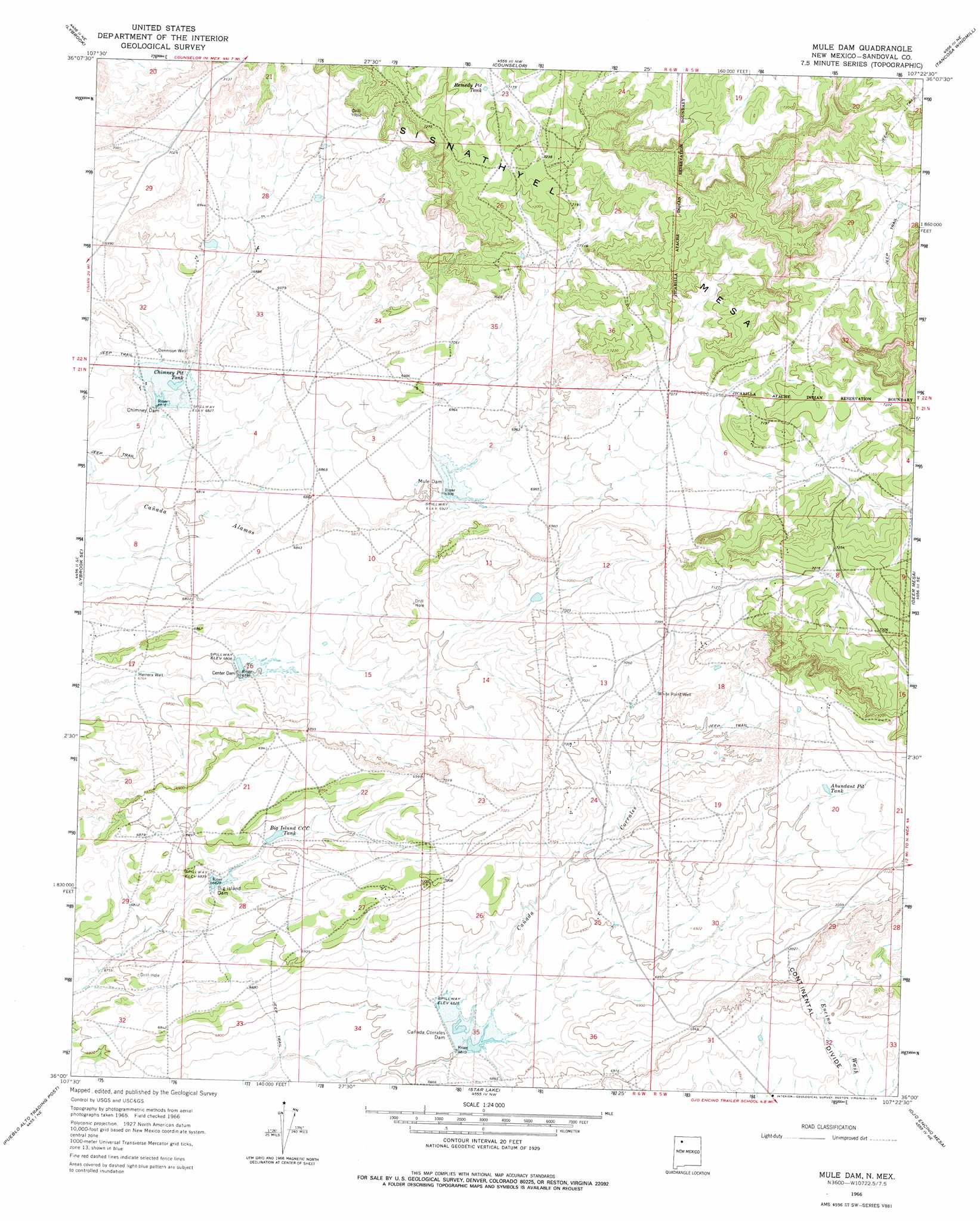
USGS Topo Quad 36107a4 - 1:24,000 scale
| Topo Map Name: | Mule Dam |
| USGS Topo Quad ID: | 36107a4 |
| Print Size: | ca. 21 1/4" wide x 27" high |
| Southeast Coordinates: | 36° N latitude / 107.375° W longitude |
| Map Center Coordinates: | 36.0625° N latitude / 107.4375° W longitude |
| U.S. State: | NM |
| Filename: | o36107a4.jpg |
| Download Map JPG Image: | Mule Dam topo map 1:24,000 scale |
| Map Type: | Topographic |
| Topo Series: | 7.5´ |
| Map Scale: | 1:24,000 |
| Source of Map Images: | United States Geological Survey (USGS) |
| Alternate Map Versions: |
Mule Dam NM 1966, updated 1969 Download PDF Buy paper map Mule Dam NM 1966, updated 1978 Download PDF Buy paper map Mule Dam NM 2010 Download PDF Buy paper map Mule Dam NM 2013 Download PDF Buy paper map |
1:24,000 Topo Quads surrounding Mule Dam
Crow Mesa West |
Crow Mesa East |
Tafoya Canyon |
Otero Store |
Billy Rice Canyon |
Lybrook Nw |
Lybrook |
Counselor |
Tancosa Windmill |
Five Lakes Canyon Nw |
Fire Rock Well |
Lybrook Se |
Mule Dam |
Deer Mesa |
Taylor Ranch |
Pueblo Pintado |
Pueblo Alto Trading Post |
Star Lake |
Ojo Encino Mesa |
Johnson Trading Post |
Whitehorse |
Whitehorse Rincon |
Rincon Marquez |
Tinian |
Wolf Stand |
> Back to 36107a1 at 1:100,000 scale
> Back to 36106a1 at 1:250,000 scale
> Back to U.S. Topo Maps home
Mule Dam topo map: Gazetteer
Mule Dam: Dams
Big Island Dam elevation 2086m 6843′Cañada Corrales Dam elevation 2082m 6830′
Canyonada Corralis Dam elevation 2082m 6830′
Center Dam elevation 2076m 6811′
Center Detention Dam elevation 2075m 6807′
Chimney Dam elevation 2082m 6830′
Chimney Detention Dam elevation 2079m 6820′
Mule Dam elevation 2112m 6929′
Mule Detention Dam elevation 2113m 6932′
Mule Dam: Reservoirs
Abundant Pit Tank elevation 2144m 7034′Big Island CCC Tank elevation 2093m 6866′
Chimney Pit Tank elevation 2082m 6830′
Remedy Pit Tank elevation 2178m 7145′
Mule Dam: Summits
Sisnathyel Mesa elevation 2263m 7424′Mule Dam: Wells
Dennison Well elevation 2086m 6843′Herrera Well elevation 2066m 6778′
White Point Well elevation 2140m 7020′
Mule Dam digital topo map on disk
Buy this Mule Dam topo map showing relief, roads, GPS coordinates and other geographical features, as a high-resolution digital map file on DVD: