Little Clayhole Valley Topo Map Arizona
To zoom in, hover over the map of Little Clayhole Valley
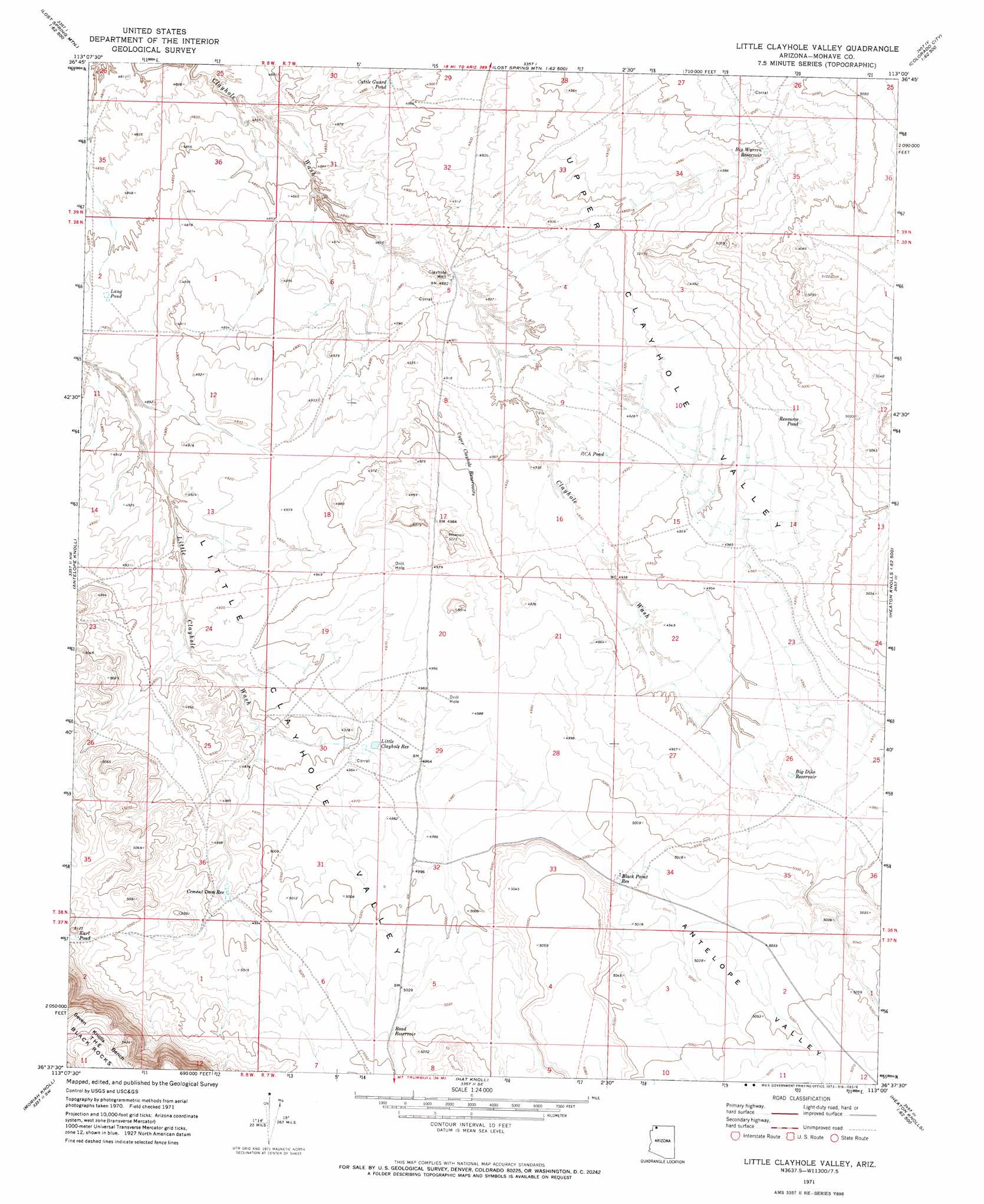
USGS Topo Quad 36113f1 - 1:24,000 scale
| Topo Map Name: | Little Clayhole Valley |
| USGS Topo Quad ID: | 36113f1 |
| Print Size: | ca. 21 1/4" wide x 27" high |
| Southeast Coordinates: | 36.625° N latitude / 113° W longitude |
| Map Center Coordinates: | 36.6875° N latitude / 113.0625° W longitude |
| U.S. State: | AZ |
| Filename: | o36113f1.jpg |
| Download Map JPG Image: | Little Clayhole Valley topo map 1:24,000 scale |
| Map Type: | Topographic |
| Topo Series: | 7.5´ |
| Map Scale: | 1:24,000 |
| Source of Map Images: | United States Geological Survey (USGS) |
| Alternate Map Versions: |
Little Clayhole Valley AZ 1971, updated 1973 Download PDF Buy paper map Little Clayhole Valley AZ 2011 Download PDF Buy paper map Little Clayhole Valley AZ 2014 Download PDF Buy paper map |
1:24,000 Topo Quads surrounding Little Clayhole Valley
Rock Canyon |
Lost Spring Mountain West |
Lost Spring Mountain East |
Colorado City |
Moccasin |
Gyp Pocket |
White Pockets |
Formaster Well |
Maroney Well |
Pipe Valley |
The Grandstand |
Antelope Knoll |
Little Clayhole Valley |
Wild Band Pockets |
Sunshine Ridge |
Russell Spring |
Moriah Knoll |
Hat Knoll |
Heaton Knolls |
Robinson Canyon |
Jones Hill |
Mount Trumbull |
Mount Trumbull Ne |
Hancock Knolls |
Hitson Tank |
> Back to 36113e1 at 1:100,000 scale
> Back to 36112a1 at 1:250,000 scale
> Back to U.S. Topo Maps home
Little Clayhole Valley topo map: Gazetteer
Little Clayhole Valley: Lakes
Cattle Guard Pond elevation 1490m 4888′Earl Pond elevation 1548m 5078′
Lang Pond elevation 1483m 4865′
RCA Pond elevation 1502m 4927′
Resource Pond elevation 1519m 4983′
Little Clayhole Valley: Reservoirs
Big Dike Reservoir elevation 1513m 4963′Big Warren Reservoir elevation 1525m 5003′
Black Point Reservoir elevation 1527m 5009′
Cement Dam Reservoir elevation 1521m 4990′
Little Clayhole Reservoir elevation 1511m 4957′
Road Reservoir elevation 1537m 5042′
Upper Clayhole Reservoirs elevation 1509m 4950′
Little Clayhole Valley: Summits
The Black Rocks elevation 1673m 5488′Little Clayhole Valley: Valleys
Antelope Valley elevation 1523m 4996′Little Clayhole Valley elevation 1489m 4885′
Upper Clayhole Valley elevation 1532m 5026′
Little Clayhole Valley: Wells
Clayhole Well elevation 1487m 4878′Little Clayhole Valley digital topo map on disk
Buy this Little Clayhole Valley topo map showing relief, roads, GPS coordinates and other geographical features, as a high-resolution digital map file on DVD: