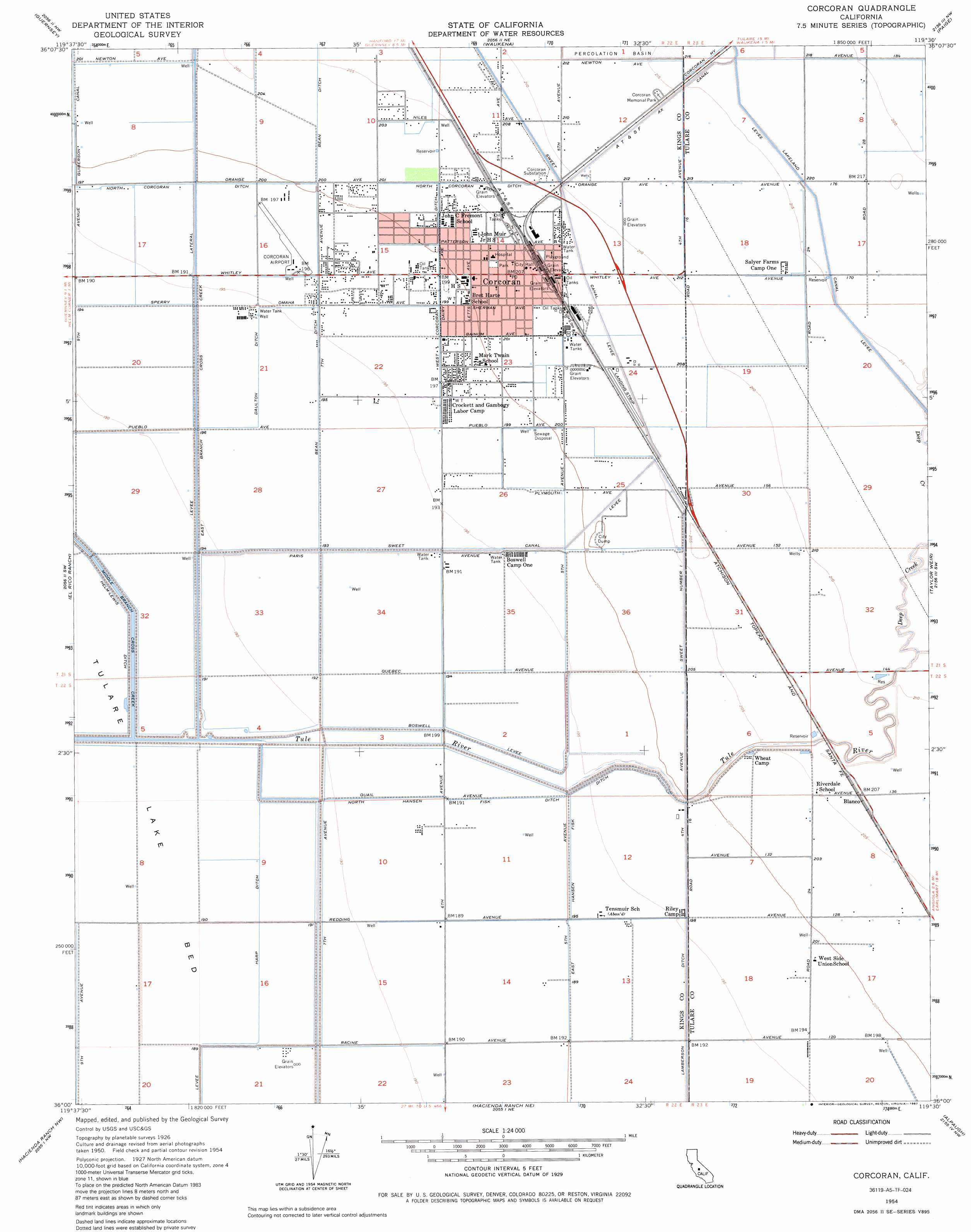
Corcoran Topo Map California
To zoom in, hover over the map of Corcoran
USGS Topo Quad 36119a5 - 1:24,000 scale
| Topo Map Name: | Corcoran |
| USGS Topo Quad ID: | 36119a5 |
| Print Size: | ca. 21 1/4" wide x 27" high |
| Southeast Coordinates: | 36° N latitude / 119.5° W longitude |
| Map Center Coordinates: | 36.0625° N latitude / 119.5625° W longitude |
| U.S. State: | CA |
| Filename: | o36119a5.jpg |
| Download Map JPG Image: | Corcoran topo map 1:24,000 scale |
| Map Type: | Topographic |
| Topo Series: | 7.5´ |
| Map Scale: | 1:24,000 |
| Source of Map Images: | United States Geological Survey (USGS) |
| Alternate Map Versions: |
Corcoran CA 1954, updated 1957 Download PDF Buy paper map Corcoran CA 1954, updated 1976 Download PDF Buy paper map Corcoran CA 1954, updated 1987 Download PDF Buy paper map Corcoran CA 2012 Download PDF Buy paper map Corcoran CA 2015 Download PDF Buy paper map |
1:24,000 Topo Quads surrounding Corcoran
Lemoore |
Hanford |
Remnoy |
Goshen |
Visalia |
Stratford |
Guernsey |
Waukena |
Paige |
Tulare |
Stratford Se |
El Rico Ranch |
Corcoran |
Taylor Weir |
Tipton |
Dudley Ridge |
Hacienda Ranch Nw |
Hacienda Ranch Ne |
Alpaugh |
Pixley |
West Camp |
Lone Tree Well |
Hacienda Ranch |
Allensworth |
Delano West |
> Back to 36119a1 at 1:100,000 scale
> Back to 36118a1 at 1:250,000 scale
> Back to U.S. Topo Maps home
Corcoran topo map: Gazetteer
Corcoran: Airports
Corcoran Airport elevation 61m 200′Salyer Farms Airport elevation 64m 209′
Corcoran: Canals
Ax Canal elevation 66m 216′Bean Ditch elevation 63m 206′
Daulton Ditch elevation 60m 196′
East Hansen Fisk Ditch elevation 60m 196′
Harp Ditch elevation 59m 193′
Lamberson Ditch elevation 60m 196′
North Corcoran Ditch elevation 63m 206′
North Hansen Fisk Ditch elevation 59m 193′
Sperry Lateral elevation 61m 200′
Sweet Canal elevation 65m 213′
West Corcoran Ditch elevation 62m 203′
Corcoran: Levees
Boswell Levee elevation 60m 196′Corcoran: Parks
Burnham Smith Park elevation 62m 203′Corcoran City Swimming Pool elevation 62m 203′
Father Wyatt Park elevation 64m 209′
John Maroot Park elevation 63m 206′
Corcoran: Populated Places
Blanco elevation 65m 213′Corcoran elevation 63m 206′
South Corcoran elevation 63m 206′
Turnbull (historical) elevation 65m 213′
Whitley Manor Mobile Home Park elevation 61m 200′
Corcoran: Post Offices
Corcoran Post Office elevation 63m 206′Corcoran: Streams
Deep Creek elevation 64m 209′East Branch Cross Creek elevation 59m 193′
Middle Branch Cross Creek elevation 58m 190′
Corcoran digital topo map on disk
Buy this Corcoran topo map showing relief, roads, GPS coordinates and other geographical features, as a high-resolution digital map file on DVD:
Southern Sierra Nevada, California & Southern Nevada
Buy digital topo maps: Southern Sierra Nevada, California & Southern Nevada