Guernsey Topo Map California
To zoom in, hover over the map of Guernsey
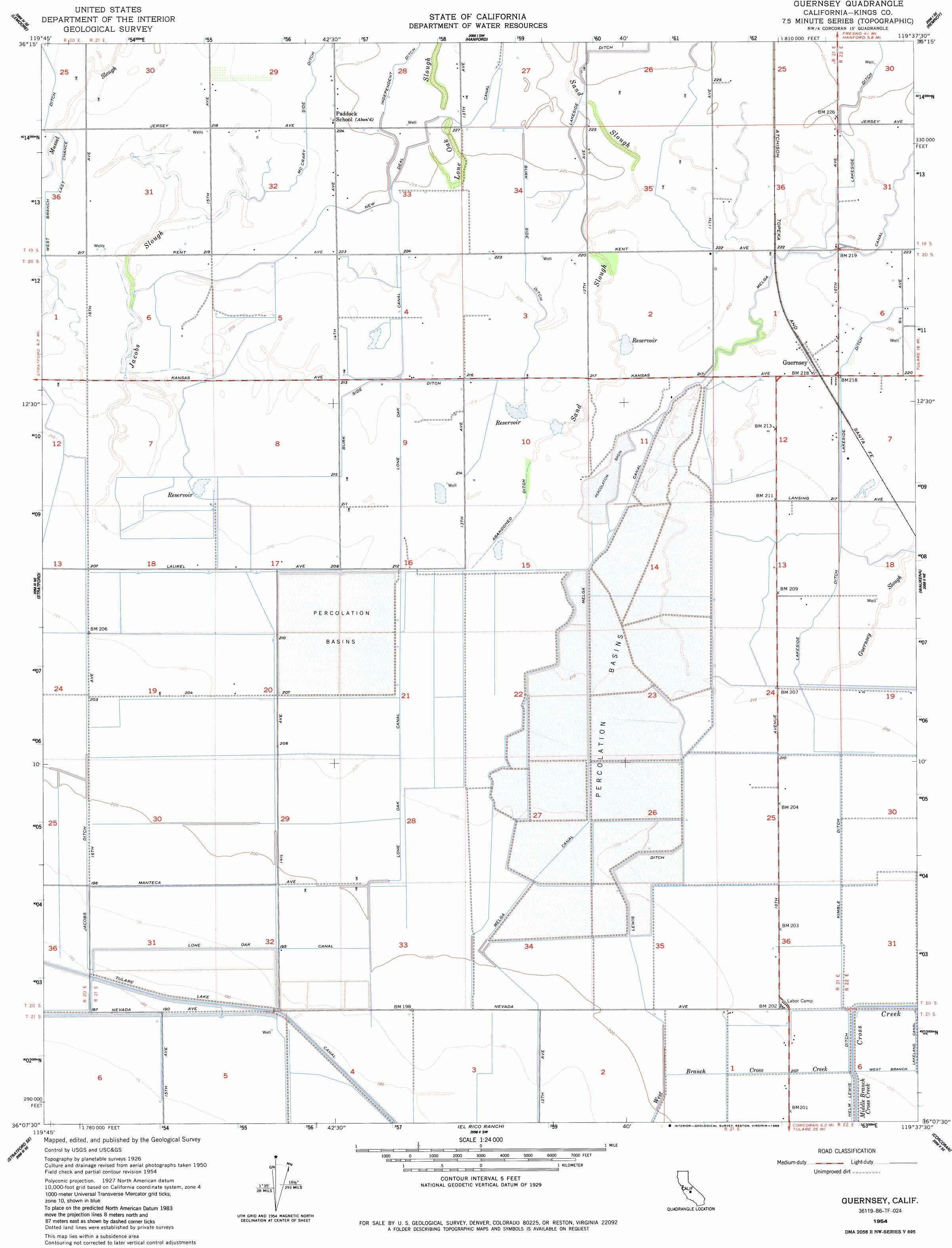
USGS Topo Quad 36119b6 - 1:24,000 scale
| Topo Map Name: | Guernsey |
| USGS Topo Quad ID: | 36119b6 |
| Print Size: | ca. 21 1/4" wide x 27" high |
| Southeast Coordinates: | 36.125° N latitude / 119.625° W longitude |
| Map Center Coordinates: | 36.1875° N latitude / 119.6875° W longitude |
| U.S. State: | CA |
| Filename: | o36119b6.jpg |
| Download Map JPG Image: | Guernsey topo map 1:24,000 scale |
| Map Type: | Topographic |
| Topo Series: | 7.5´ |
| Map Scale: | 1:24,000 |
| Source of Map Images: | United States Geological Survey (USGS) |
| Alternate Map Versions: |
Guernsey CA 1954, updated 1957 Download PDF Buy paper map Guernsey CA 1954, updated 1959 Download PDF Buy paper map Guernsey CA 1954, updated 1984 Download PDF Buy paper map Guernsey CA 1954, updated 1986 Download PDF Buy paper map Guernsey CA 2012 Download PDF Buy paper map Guernsey CA 2015 Download PDF Buy paper map |
1:24,000 Topo Quads surrounding Guernsey
Burrel |
Riverdale |
Laton |
Burris Park |
Traver |
Vanguard |
Lemoore |
Hanford |
Remnoy |
Goshen |
Westhaven |
Stratford |
Guernsey |
Waukena |
Paige |
Kettleman City |
Stratford Se |
El Rico Ranch |
Corcoran |
Taylor Weir |
Los Viejos |
Dudley Ridge |
Hacienda Ranch Nw |
Hacienda Ranch Ne |
Alpaugh |
> Back to 36119a1 at 1:100,000 scale
> Back to 36118a1 at 1:250,000 scale
> Back to U.S. Topo Maps home
Guernsey topo map: Gazetteer
Guernsey: Canals
Burk Side Ditch elevation 68m 223′Guiberson Canal elevation 64m 209′
Jacobs Ditch elevation 65m 213′
Kimble Ditch elevation 64m 209′
Lakeside Ditch elevation 69m 226′
Last Chance Ditch elevation 64m 209′
Lewis Ditch elevation 63m 206′
Lone Oak Canal elevation 67m 219′
Melga Canal elevation 66m 216′
New Deal Canal elevation 70m 229′
Tulare Lake Canal elevation 59m 193′
Guernsey: Guts
Mussel Slough elevation 67m 219′Sand Slough elevation 68m 223′
Guernsey: Populated Places
Guernsey elevation 68m 223′Guernsey: Streams
Cross Creek elevation 63m 206′Guernsey Slough elevation 65m 213′
Jacobs Slough elevation 65m 213′
Guernsey digital topo map on disk
Buy this Guernsey topo map showing relief, roads, GPS coordinates and other geographical features, as a high-resolution digital map file on DVD:
Southern Sierra Nevada, California & Southern Nevada
Buy digital topo maps: Southern Sierra Nevada, California & Southern Nevada