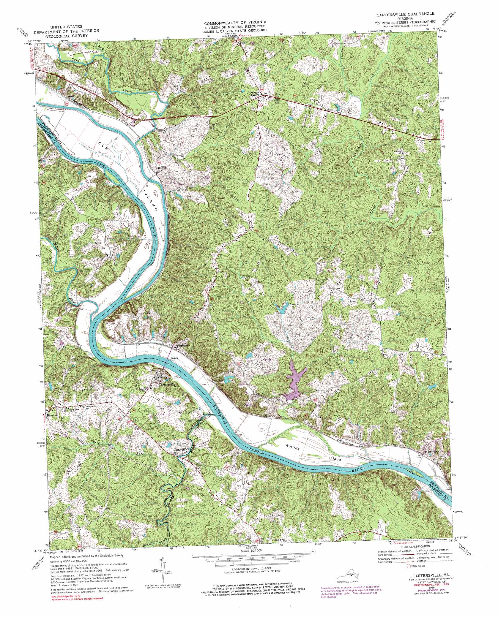
Cartersville Topo Map Virginia
To zoom in, hover over the map of Cartersville
USGS Topo Quad 37078f1 - 1:24,000 scale
| Topo Map Name: | Cartersville |
| USGS Topo Quad ID: | 37078f1 |
| Print Size: | ca. 21 1/4" wide x 27" high |
| Southeast Coordinates: | 37.625° N latitude / 78° W longitude |
| Map Center Coordinates: | 37.6875° N latitude / 78.0625° W longitude |
| U.S. State: | VA |
| Filename: | o37078f1.jpg |
| Download Map JPG Image: | Cartersville topo map 1:24,000 scale |
| Map Type: | Topographic |
| Topo Series: | 7.5´ |
| Map Scale: | 1:24,000 |
| Source of Map Images: | United States Geological Survey (USGS) |
| Alternate Map Versions: |
Cartersville VA 1969, updated 1971 Download PDF Buy paper map Cartersville VA 1969, updated 1976 Download PDF Buy paper map Cartersville VA 1969, updated 1984 Download PDF Buy paper map Cartersville VA 2010 Download PDF Buy paper map Cartersville VA 2013 Download PDF Buy paper map Cartersville VA 2016 Download PDF Buy paper map |
1:24,000 Topo Quads surrounding Cartersville
Boyd Tavern |
Zion Crossroads |
Ferncliff |
Pendleton |
Buckner |
Palmyra |
Columbia |
Caledonia |
South Anna |
Dabneys |
Arvonia |
Lakeside Village |
Cartersville |
Goochland |
Perkinsville |
Gold Hill |
Whiteville |
Trenholm |
Powhatan |
Fine Creek Mills |
Hillcrest |
Cumberland |
Ballsville |
Chula |
Clayville |
> Back to 37078e1 at 1:100,000 scale
> Back to 37078a1 at 1:250,000 scale
> Back to U.S. Topo Maps home
Cartersville topo map: Gazetteer
Cartersville: Airports
Stokes Airport elevation 77m 252′Cartersville: Dams
Knorr Dam elevation 76m 249′Picketts Creek Dam elevation 60m 196′
Queensmeer Dam elevation 74m 242′
Volchers Dam elevation 81m 265′
Cartersville: Islands
Bolling Island elevation 55m 180′Elk Island elevation 57m 187′
Cartersville: Populated Places
Cartersville elevation 79m 259′Dogwood Acres elevation 104m 341′
Elk Hill elevation 67m 219′
Fife elevation 110m 360′
Georges Tavern elevation 105m 344′
Hamilton elevation 107m 351′
Hunters Trail elevation 101m 331′
James River Landing elevation 97m 318′
Pemberton elevation 60m 196′
Stokes (historical) elevation 57m 187′
Tamworth elevation 55m 180′
West View elevation 56m 183′
Cartersville: Reservoirs
Picketts Creek Reservoir elevation 60m 196′Queensmeer Lake elevation 74m 242′
Cartersville: Streams
Byrd Creek elevation 55m 180′Davis Creek elevation 57m 187′
Deep Run elevation 57m 187′
Little Byrd Creek elevation 57m 187′
Muddy Creek elevation 52m 170′
Tarred Rat Creek elevation 62m 203′
Willis River elevation 52m 170′
Cartersville digital topo map on disk
Buy this Cartersville topo map showing relief, roads, GPS coordinates and other geographical features, as a high-resolution digital map file on DVD:
Western Virginia & Southern West Virginia
Buy digital topo maps: Western Virginia & Southern West Virginia