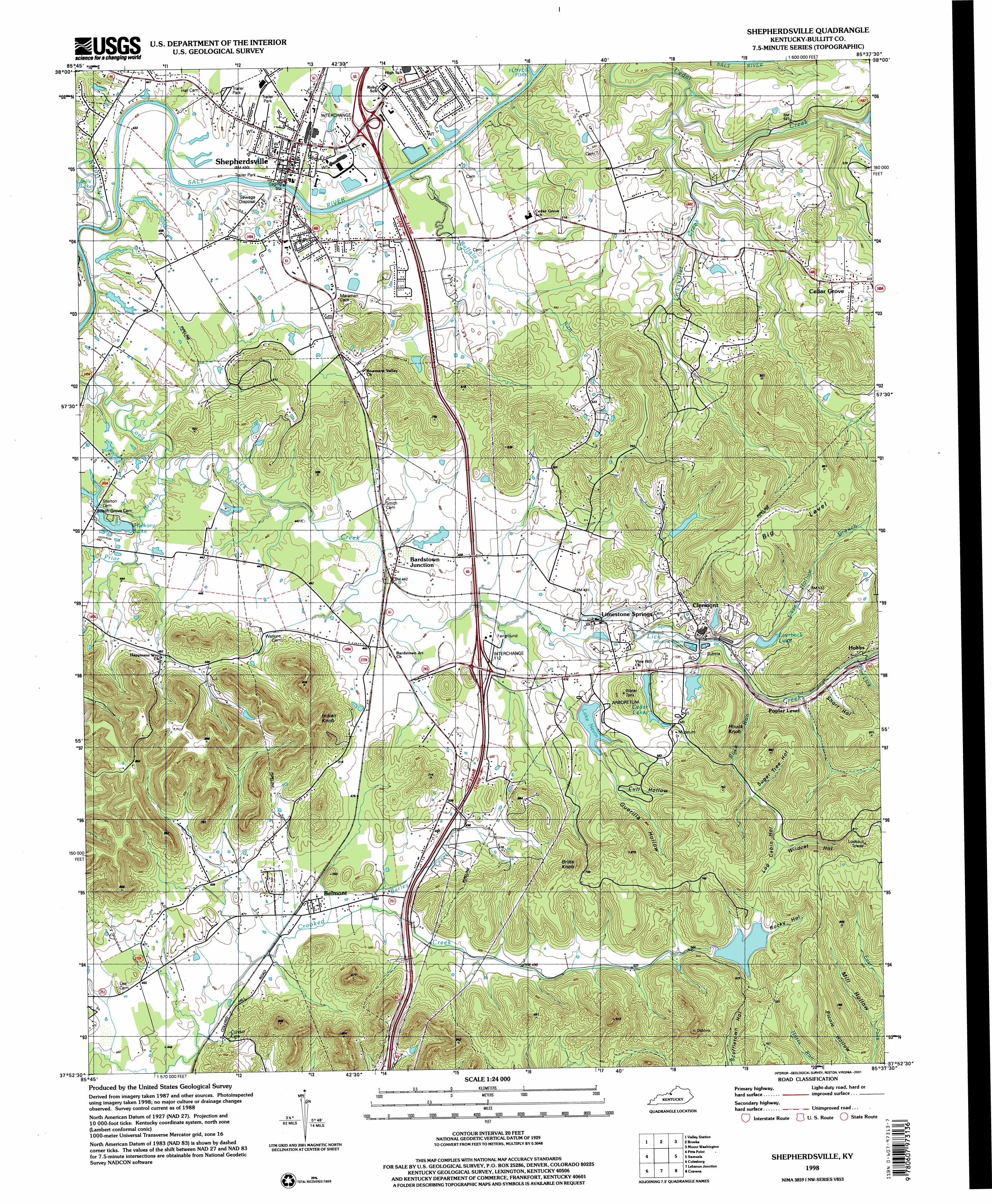
Shepherdsville Topo Map Kentucky
To zoom in, hover over the map of Shepherdsville
USGS Topo Quad 37085h6 - 1:24,000 scale
| Topo Map Name: | Shepherdsville |
| USGS Topo Quad ID: | 37085h6 |
| Print Size: | ca. 21 1/4" wide x 27" high |
| Southeast Coordinates: | 37.875° N latitude / 85.625° W longitude |
| Map Center Coordinates: | 37.9375° N latitude / 85.6875° W longitude |
| U.S. State: | KY |
| Filename: | o37085h6.jpg |
| Download Map JPG Image: | Shepherdsville topo map 1:24,000 scale |
| Map Type: | Topographic |
| Topo Series: | 7.5´ |
| Map Scale: | 1:24,000 |
| Source of Map Images: | United States Geological Survey (USGS) |
| Alternate Map Versions: |
Shepherdsville KY 1949, updated 1952 Download PDF Buy paper map Shepherdsville KY 1962, updated 1964 Download PDF Buy paper map Shepherdsville KY 1962, updated 1972 Download PDF Buy paper map Shepherdsville KY 1962, updated 1987 Download PDF Buy paper map Shepherdsville KY 1991, updated 1992 Download PDF Buy paper map Shepherdsville KY 1998, updated 2001 Download PDF Buy paper map Shepherdsville KY 2010 Download PDF Buy paper map Shepherdsville KY 2013 Download PDF Buy paper map Shepherdsville KY 2016 Download PDF Buy paper map |
1:24,000 Topo Quads surrounding Shepherdsville
Lanesville |
Louisville West |
Louisville East |
Jeffersontown |
Fisherville |
Kosmosdale |
Valley Station |
Brooks |
Mount Washington |
Waterford |
Fort Knox |
Pitts Point |
Shepherdsville |
Samuels |
Fairfield |
Vine Grove |
Colesburg |
Lebanon Junction |
Cravens |
Bardstown |
Cecilia |
Elizabethtown |
Nelsonville |
New Haven |
Loretto |
> Back to 37085e1 at 1:100,000 scale
> Back to 37084a1 at 1:250,000 scale
> Back to U.S. Topo Maps home
Shepherdsville topo map: Gazetteer
Shepherdsville: Crossings
Interchange 117 elevation 139m 456′Interchange 4 elevation 142m 465′
Interchange 5 elevation 141m 462′
Shepherdsville: Flats
Big Level elevation 246m 807′Shepherdsville: Forests
Knobs State Forest and Wildlife Management Area elevation 213m 698′Shepherdsville: Lakes
Cedar Lakes elevation 156m 511′Lake Nevin elevation 152m 498′
Shepherdsville: Populated Places
Bardstown Junction elevation 135m 442′Belmont elevation 139m 456′
Cedar Grove elevation 165m 541′
Clermont elevation 163m 534′
Hobbs elevation 179m 587′
Limestone Springs elevation 144m 472′
Poplar Level elevation 167m 547′
Salt River elevation 135m 442′
Shepherdsville elevation 137m 449′
Shepherdsville: Post Offices
Bardstown Junction Post Office (historical) elevation 135m 442′Shepherdsville: Reservoirs
Everback Lake elevation 147m 482′Shepherdsville: Streams
Barley Creek elevation 138m 452′Buffalo Run elevation 133m 436′
Bullitt Lick Creek elevation 119m 390′
Cave Hollow Branch elevation 141m 462′
Elm Lick elevation 160m 524′
Floyds Fork elevation 129m 423′
Lickskillet Creek elevation 132m 433′
Prior Branch elevation 126m 413′
Rock Run elevation 146m 479′
Slate Run elevation 173m 567′
Shepherdsville: Summits
Britts Knob elevation 250m 820′Houck Knob elevation 238m 780′
Indian Knob elevation 255m 836′
Shepherdsville: Valleys
Cull Hollow elevation 158m 518′Guerilla Hollow elevation 158m 518′
Jackson Hollow elevation 145m 475′
Log Cabin Hollow elevation 173m 567′
Rocky Hollow elevation 175m 574′
Short Hollow elevation 165m 541′
Sugar Tree Hollow elevation 177m 580′
Wildcat Hollow elevation 188m 616′
Shepherdsville digital topo map on disk
Buy this Shepherdsville topo map showing relief, roads, GPS coordinates and other geographical features, as a high-resolution digital map file on DVD: