Windyville Topo Map Missouri
To zoom in, hover over the map of Windyville
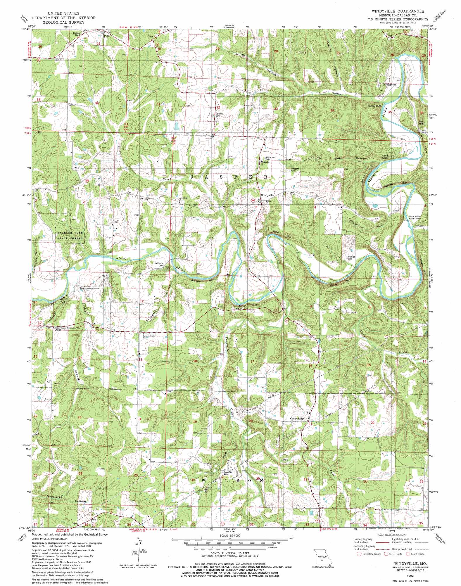
USGS Topo Quad 37092f8 - 1:24,000 scale
| Topo Map Name: | Windyville |
| USGS Topo Quad ID: | 37092f8 |
| Print Size: | ca. 21 1/4" wide x 27" high |
| Southeast Coordinates: | 37.625° N latitude / 92.875° W longitude |
| Map Center Coordinates: | 37.6875° N latitude / 92.9375° W longitude |
| U.S. State: | MO |
| Filename: | o37092f8.jpg |
| Download Map JPG Image: | Windyville topo map 1:24,000 scale |
| Map Type: | Topographic |
| Topo Series: | 7.5´ |
| Map Scale: | 1:24,000 |
| Source of Map Images: | United States Geological Survey (USGS) |
| Alternate Map Versions: |
Windyville MO 1982, updated 1983 Download PDF Buy paper map Windyville MO 2011 Download PDF Buy paper map Windyville MO 2015 Download PDF Buy paper map |
1:24,000 Topo Quads surrounding Windyville
Preston |
Branch |
Macks Creek |
Hahatonka |
Decaturville |
Urbana |
Tunas |
Leadmine |
Eldridge West |
Eldridge East |
Buffalo Nw |
Buffalo |
Windyville |
Bennett Springs |
Lebanon |
Half Way |
Charity |
Long Lake |
Phillipsburg |
Brush Creek |
Fair Grove |
Elkland |
Beach |
Niangua |
Rader |
> Back to 37092e1 at 1:100,000 scale
> Back to 37092a1 at 1:250,000 scale
> Back to U.S. Topo Maps home
Windyville topo map: Gazetteer
Windyville: Airports
Sugartree Airport elevation 373m 1223′Windyville: Cliffs
Bramwell Bluff elevation 309m 1013′Burtin Bluff elevation 314m 1030′
Cowan Bluff elevation 319m 1046′
Flanagan Bluff elevation 313m 1026′
Freeman Bluff elevation 297m 974′
Hildebrand Bluff elevation 315m 1033′
Kahler Bluff elevation 308m 1010′
Mary Sharp Bluff elevation 311m 1020′
Smith Bluff elevation 311m 1020′
Windyville: Dams
Hutton Lake Dam elevation 315m 1033′Windyville: Forests
Hackler Ford State Forest elevation 293m 961′Windyville: Populated Places
Cedar Ridge elevation 355m 1164′Dallion Ford (historical) elevation 286m 938′
Hackler Ford (historical) elevation 281m 921′
Plad elevation 360m 1181′
Tilden elevation 330m 1082′
Windyville elevation 327m 1072′
Windyville: Streams
Bell Fork elevation 298m 977′Benton Branch elevation 282m 925′
Bramwell Branch elevation 279m 915′
Cave Creek elevation 268m 879′
Dry Fork elevation 300m 984′
Durington Creek elevation 286m 938′
Fourmile Creek elevation 275m 902′
Indian Creek elevation 279m 915′
Jerktail Branch elevation 286m 938′
Windyville: Valleys
Cat Hollow elevation 262m 859′County Road Hollow elevation 265m 869′
Granny Hollow elevation 286m 938′
North Hollow elevation 278m 912′
Schoolhouse Hollow elevation 267m 875′
Windyville digital topo map on disk
Buy this Windyville topo map showing relief, roads, GPS coordinates and other geographical features, as a high-resolution digital map file on DVD: