La Junta Sw Topo Map Colorado
To zoom in, hover over the map of La Junta Sw
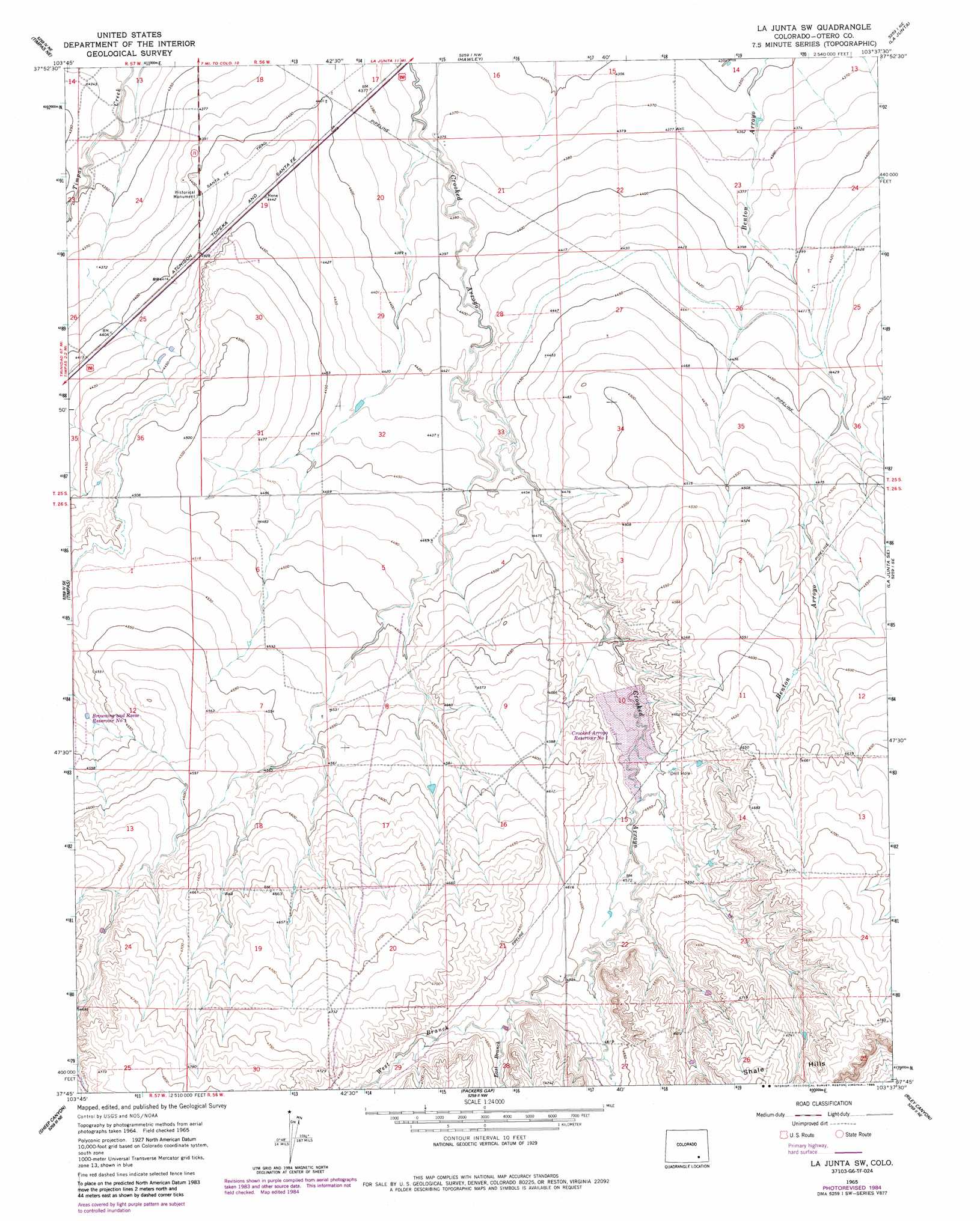
USGS Topo Quad 37103g6 - 1:24,000 scale
| Topo Map Name: | La Junta Sw |
| USGS Topo Quad ID: | 37103g6 |
| Print Size: | ca. 21 1/4" wide x 27" high |
| Southeast Coordinates: | 37.75° N latitude / 103.625° W longitude |
| Map Center Coordinates: | 37.8125° N latitude / 103.6875° W longitude |
| U.S. State: | CO |
| Filename: | o37103g6.jpg |
| Download Map JPG Image: | La Junta Sw topo map 1:24,000 scale |
| Map Type: | Topographic |
| Topo Series: | 7.5´ |
| Map Scale: | 1:24,000 |
| Source of Map Images: | United States Geological Survey (USGS) |
| Alternate Map Versions: |
La Junta SW CO 1965, updated 1969 Download PDF Buy paper map La Junta SW CO 1965, updated 1985 Download PDF Buy paper map La Junta SW CO 1996, updated 2000 Download PDF Buy paper map La Junta SW CO 2011 Download PDF Buy paper map La Junta SW CO 2013 Download PDF Buy paper map La Junta SW CO 2016 Download PDF Buy paper map |
| FStopo: | US Forest Service topo La Junta SW is available: Download FStopo PDF Download FStopo TIF |
1:24,000 Topo Quads surrounding La Junta Sw
Elder |
Manzanola |
Rocky Ford |
Cheraw |
Hadley |
Timpas Nw |
Timpas Ne |
Hawley |
La Junta |
Thompson Arroyo |
Timpas Sw |
Timpas |
La Junta Sw |
La Junta Se |
Higbee |
Bloom |
Sheep Canyon |
Packers Gap |
Riley Canyon |
Corbin Canyon |
Lockwood Arroyo |
Stage Canyon |
O V Mesa |
Beaty Canyon |
Lost Canyon |
> Back to 37103e1 at 1:100,000 scale
> Back to 37102a1 at 1:250,000 scale
> Back to U.S. Topo Maps home
La Junta Sw topo map: Gazetteer
La Junta Sw: Streams
East Branch Crooked Arroyo elevation 1409m 4622′West Branch Crooked Arroyo elevation 1409m 4622′
La Junta Sw digital topo map on disk
Buy this La Junta Sw topo map showing relief, roads, GPS coordinates and other geographical features, as a high-resolution digital map file on DVD: