Timpas Sw Topo Map Colorado
To zoom in, hover over the map of Timpas Sw
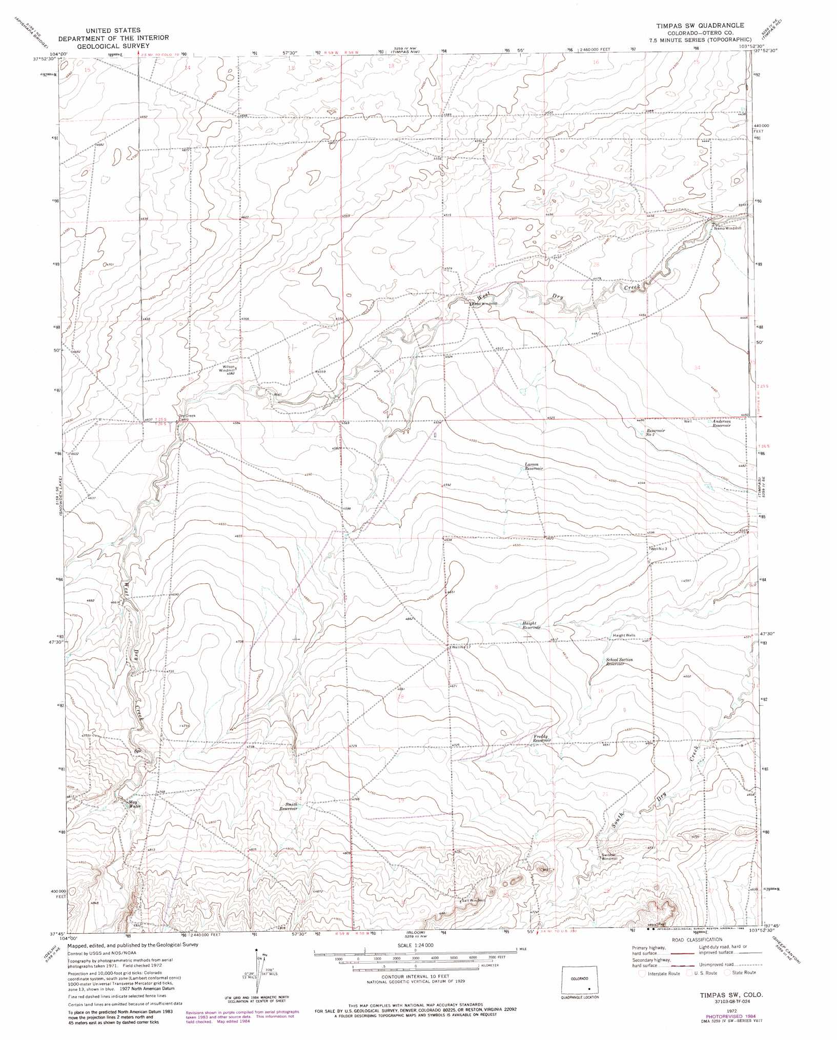
USGS Topo Quad 37103g8 - 1:24,000 scale
| Topo Map Name: | Timpas Sw |
| USGS Topo Quad ID: | 37103g8 |
| Print Size: | ca. 21 1/4" wide x 27" high |
| Southeast Coordinates: | 37.75° N latitude / 103.875° W longitude |
| Map Center Coordinates: | 37.8125° N latitude / 103.9375° W longitude |
| U.S. State: | CO |
| Filename: | o37103g8.jpg |
| Download Map JPG Image: | Timpas Sw topo map 1:24,000 scale |
| Map Type: | Topographic |
| Topo Series: | 7.5´ |
| Map Scale: | 1:24,000 |
| Source of Map Images: | United States Geological Survey (USGS) |
| Alternate Map Versions: |
Timpas SW CO 1972, updated 1976 Download PDF Buy paper map Timpas SW CO 1972, updated 1985 Download PDF Buy paper map Timpas SW CO 1972, updated 1985 Download PDF Buy paper map Timpas SW CO 1996, updated 2000 Download PDF Buy paper map Timpas SW CO 2011 Download PDF Buy paper map Timpas SW CO 2013 Download PDF Buy paper map Timpas SW CO 2016 Download PDF Buy paper map |
| FStopo: | US Forest Service topo Timpas SW is available: Download FStopo PDF Download FStopo TIF |
1:24,000 Topo Quads surrounding Timpas Sw
Flying A Ranch |
Hardesty Reservoir |
Elder |
Manzanola |
Rocky Ford |
Yellowbank Creek |
Apishapa Bridge |
Timpas Nw |
Timpas Ne |
Hawley |
Sanford Hills |
Snowden Lake |
Timpas Sw |
Timpas |
La Junta Sw |
Sun Valley Ranch |
Delhi |
Bloom |
Sheep Canyon |
Packers Gap |
Bates Lake |
Thatcher |
Lockwood Arroyo |
Stage Canyon |
O V Mesa |
> Back to 37103e1 at 1:100,000 scale
> Back to 37102a1 at 1:250,000 scale
> Back to U.S. Topo Maps home
Timpas Sw topo map: Gazetteer
Timpas Sw: Lakes
May Water elevation 1451m 4760′Timpas Sw: Reservoirs
Anderson Reservoir elevation 1362m 4468′Freddy Reservoir elevation 1420m 4658′
Haight Reservoir elevation 1409m 4622′
Larson Reservoir elevation 1391m 4563′
School Section Reservoir elevation 1402m 4599′
Smith Reservoir elevation 1452m 4763′
Timpas Sw: Wells
Haight Wells elevation 1397m 4583′Timpas Sw digital topo map on disk
Buy this Timpas Sw topo map showing relief, roads, GPS coordinates and other geographical features, as a high-resolution digital map file on DVD: