Rhyolite Ridge Topo Map Nevada
To zoom in, hover over the map of Rhyolite Ridge
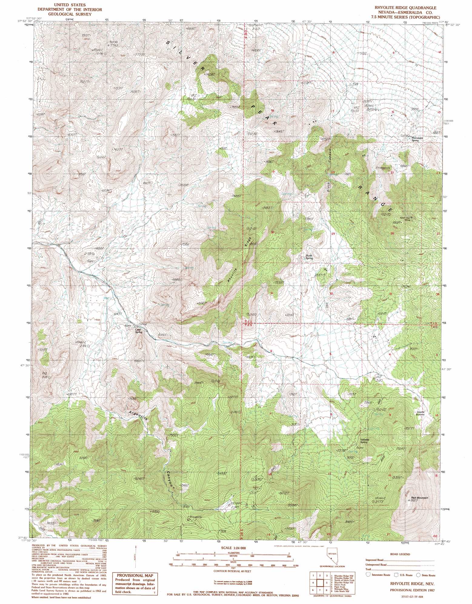
USGS Topo Quad 37117g7 - 1:24,000 scale
| Topo Map Name: | Rhyolite Ridge |
| USGS Topo Quad ID: | 37117g7 |
| Print Size: | ca. 21 1/4" wide x 27" high |
| Southeast Coordinates: | 37.75° N latitude / 117.75° W longitude |
| Map Center Coordinates: | 37.8125° N latitude / 117.8125° W longitude |
| U.S. State: | NV |
| Filename: | o37117g7.jpg |
| Download Map JPG Image: | Rhyolite Ridge topo map 1:24,000 scale |
| Map Type: | Topographic |
| Topo Series: | 7.5´ |
| Map Scale: | 1:24,000 |
| Source of Map Images: | United States Geological Survey (USGS) |
| Alternate Map Versions: |
Rhyolite Ridge NV 1987, updated 1987 Download PDF Buy paper map Rhyolite Ridge NV 2011 Download PDF Buy paper map Rhyolite Ridge NV 2014 Download PDF Buy paper map |
1:24,000 Topo Quads surrounding Rhyolite Ridge
Columbus |
Coaldale |
Blair Junction |
Devils Gate |
Gilbert Se |
Volcanic Hills East |
Rhyolite Ridge Nw |
Rhyolite Ridge Ne |
North Of Silver Peak |
Weepah |
East Of Davis Mountain |
Rhyolite Ridge Sw |
Rhyolite Ridge |
Silver Peak |
Goat Island |
Dyer |
Piper Peak |
Mohawk Mine |
Lida Wash Nw |
Alcatraz Island |
Station Peak |
Indian Garden Creek |
Oasis Divide |
Lida Wash Sw |
Lida Wash |
> Back to 37117e1 at 1:100,000 scale
> Back to 37116a1 at 1:250,000 scale
> Back to U.S. Topo Maps home
Rhyolite Ridge topo map: Gazetteer
Rhyolite Ridge: Gaps
Coyote Summit elevation 2214m 7263′Rhyolite Ridge: Mines
Black Rock Mine elevation 2337m 7667′Gold Number One Mine elevation 2351m 7713′
North Star Mine elevation 2279m 7477′
Silver Queen Mine elevation 2418m 7933′
Rhyolite Ridge: Populated Places
Coyote Hole elevation 2015m 6610′Rhyolite Ridge: Ridges
Rhyolite Ridge elevation 2573m 8441′Rhyolite Ridge: Springs
Cave Spring elevation 1946m 6384′Coyote Hole elevation 2015m 6610′
Mamie Spring elevation 2143m 7030′
Minnesota Spring elevation 1849m 6066′
North Spring elevation 2196m 7204′
Red Mountain Spring elevation 2355m 7726′
Valcalda Spring elevation 2222m 7290′
Rhyolite Ridge: Summits
Red Mountain elevation 2702m 8864′Rhyolite Ridge: Valleys
Argentite Canyon elevation 1962m 6437′Black Canyon elevation 1821m 5974′
Rhyolite Ridge digital topo map on disk
Buy this Rhyolite Ridge topo map showing relief, roads, GPS coordinates and other geographical features, as a high-resolution digital map file on DVD: