Weepah Topo Map Nevada
To zoom in, hover over the map of Weepah
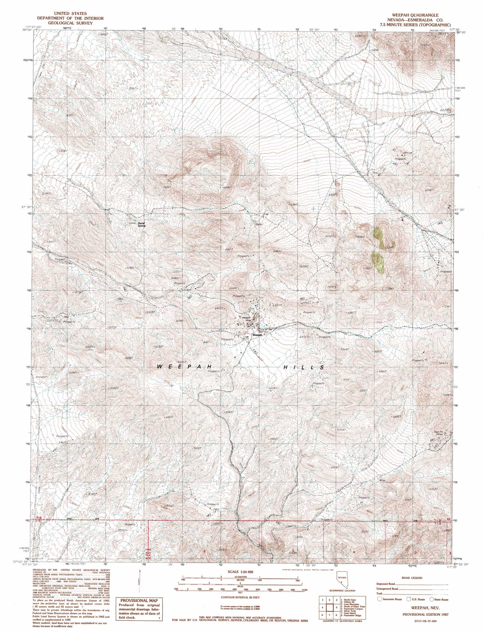
USGS Topo Quad 37117h5 - 1:24,000 scale
| Topo Map Name: | Weepah |
| USGS Topo Quad ID: | 37117h5 |
| Print Size: | ca. 21 1/4" wide x 27" high |
| Southeast Coordinates: | 37.875° N latitude / 117.5° W longitude |
| Map Center Coordinates: | 37.9375° N latitude / 117.5625° W longitude |
| U.S. State: | NV |
| Filename: | o37117h5.jpg |
| Download Map JPG Image: | Weepah topo map 1:24,000 scale |
| Map Type: | Topographic |
| Topo Series: | 7.5´ |
| Map Scale: | 1:24,000 |
| Source of Map Images: | United States Geological Survey (USGS) |
| Alternate Map Versions: |
Weepah NV 1987, updated 1987 Download PDF Buy paper map Weepah NV 2011 Download PDF Buy paper map Weepah NV 2014 Download PDF Buy paper map |
1:24,000 Topo Quads surrounding Weepah
Coaldale Ne |
Gilbert |
Crow Springs |
Millers |
Crescent Dunes |
Blair Junction |
Devils Gate |
Gilbert Se |
Lone Mountain |
Mount Butte |
Rhyolite Ridge Ne |
North Of Silver Peak |
Weepah |
Paymaster Canyon |
Klondike |
Rhyolite Ridge |
Silver Peak |
Goat Island |
Paymaster Ridge |
Alkali |
Mohawk Mine |
Lida Wash Nw |
Alcatraz Island |
Split Mountain |
Montezuma Peak |
> Back to 37117e1 at 1:100,000 scale
> Back to 37116a1 at 1:250,000 scale
> Back to U.S. Topo Maps home
Weepah topo map: Gazetteer
Weepah: Mines
American Mine elevation 1756m 5761′Electric Gold Mines elevation 1877m 6158′
Jet Mine elevation 1797m 5895′
The Wee Pah Lookout Mines elevation 1877m 6158′
United Weepah and Western Mines Corporation Mines elevation 1877m 6158′
Weepah Combination Mines elevation 1877m 6158′
Weepah Development and Mines Company Mines elevation 1877m 6158′
Weepah Diamond Gold Mining Company Mines elevation 1877m 6158′
Weepah Discovery Gold Mines Company Mines elevation 1877m 6158′
Weepah Electric Extension Gold Mining Company Mines elevation 1877m 6158′
Weepah Gold Mines Company Mines elevation 1877m 6158′
Weepah Horton Junior Gold Mines Company Mines elevation 1877m 6158′
Weepah Metals Corporation Mines elevation 1877m 6158′
Weepah Mine elevation 1898m 6227′
Weepah Nevada Mining Company Mines elevation 1877m 6158′
Weepah United Mines elevation 1877m 6158′
Weepah: Populated Places
Barrel Spring (historical) elevation 1682m 5518′Weepah elevation 1877m 6158′
Weepah: Post Offices
Weepah Post Office elevation 1876m 6154′Weepah: Ranges
Weepah Hills elevation 2068m 6784′Weepah: Springs
Barrel Spring elevation 1687m 5534′Weepah digital topo map on disk
Buy this Weepah topo map showing relief, roads, GPS coordinates and other geographical features, as a high-resolution digital map file on DVD: