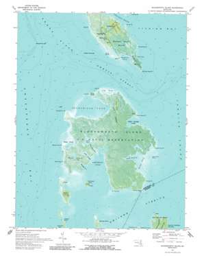
Bloodsworth Island Topo Map Maryland
To zoom in, hover over the map of Bloodsworth Island
USGS Topo Quad 38076b1 - 1:24,000 scale
| Topo Map Name: | Bloodsworth Island |
| USGS Topo Quad ID: | 38076b1 |
| Print Size: | ca. 21 1/4" wide x 27" high |
| Southeast Coordinates: | 38.125° N latitude / 76° W longitude |
| Map Center Coordinates: | 38.1875° N latitude / 76.0625° W longitude |
| U.S. State: | MD |
| Filename: | p38076b1.jpg |
| Download Map JPG Image: | Bloodsworth Island topo map 1:24,000 scale |
| Map Type: | Orthophoto |
| Topo Series: | 7.5´ |
| Map Scale: | 1:24,000 |
| Source of Map Images: | United States Geological Survey (USGS) |
| Alternate Map Versions: |
Bloodsworth Island MD 1942, updated 1957 Download PDF Buy paper map Bloodsworth Island MD 1973, updated 1975 Download PDF Buy paper map Bloodsworth Island MD 1973, updated 1988 Download PDF Buy paper map Bloodsworth Island MD 2011 Download PDF Buy paper map Bloodsworth Island MD 2014 Download PDF Buy paper map Bloodsworth Island MD 2017 Download PDF Buy paper map |
1:24,000 Topo Quads surrounding Bloodsworth Island
> Back to 38076a1 at 1:100,000 scale
> Back to 38076a1 at 1:250,000 scale
> Back to U.S. Topo Maps home
Bloodsworth Island topo map: Gazetteer
Bloodsworth Island: Bars
Amos Bar elevation 0m 0′The Gunbarrel elevation 0m 0′
Bloodsworth Island: Bays
Great Cove elevation 0m 0′Great Cove Creek elevation 1m 3′
Holland Island Bay elevation 0m 0′
Hopkins Cove elevation 0m 0′
Long Creek elevation 0m 0′
Muddy Creek elevation 0m 0′
Northeast Cove elevation 0m 0′
Okahanikan Cove elevation 0m 0′
Piney Island Cove elevation 0m 0′
Pone Cove elevation 0m 0′
Tigs Cove elevation 0m 0′
Todd Cove elevation 0m 0′
Bloodsworth Island: Capes
Bishops Head elevation 1m 3′Bishops Head Point elevation 0m 0′
Bloodsworth Point elevation 0m 0′
Cove Point elevation 0m 0′
Fishing Point elevation 0m 0′
Great Cove Point elevation 0m 0′
Gunbarrel Point elevation 0m 0′
Hope Point elevation 1m 3′
Kits Point elevation 0m 0′
Lower Island Point elevation 0m 0′
Okahanikan Point elevation 0m 0′
Piney Island Point elevation 1m 3′
Race Hog Point elevation 0m 0′
Sound Point (historical) elevation 0m 0′
Straddling Point elevation 0m 0′
Straits Point elevation 0m 0′
Tigs Point elevation 0m 0′
Bloodsworth Island: Channels
Holland Straits elevation 0m 0′Hooper Strait elevation 0m 0′
Bloodsworth Island: Islands
Adam Island elevation 0m 0′Billys Island elevation 0m 0′
Bloodsworth Island elevation 0m 0′
Bobbin Island elevation 0m 0′
Courtnay Island (historical) elevation 0m 0′
Deep Banks Island elevation 0m 0′
Great Cove Island elevation 0m 0′
Jenny Island elevation 0m 0′
Long Island (historical) elevation 0m 0′
Northeast Island elevation 0m 0′
Pone Island elevation 0m 0′
South Marsh Island elevation 0m 0′
Spring Island elevation 0m 0′
Turtle Egg Island (historical) elevation 0m 0′
Bloodsworth Island: Lakes
Swan Pond elevation -2m -7′Bloodsworth Island: Populated Places
Crocheron elevation 1m 3′Hog Island elevation 0m 0′
Bloodsworth Island: Ridges
Fin Creek Ridge elevation 1m 3′Bloodsworth Island: Streams
Fin Creek elevation 0m 0′Honga River elevation 0m 0′
Lillys Creek elevation 0m 0′
Swan Pond Creek elevation 0m 0′
Tedious Creek elevation 0m 0′
Bloodsworth Island: Swamps
Bishops Head Marsh elevation 1m 3′Bloodsworth Island digital topo map on disk
Buy this Bloodsworth Island topo map showing relief, roads, GPS coordinates and other geographical features, as a high-resolution digital map file on DVD:
Atlantic Coast (NY, NJ, PA, DE, MD, VA, NC)
Buy digital topo maps: Atlantic Coast (NY, NJ, PA, DE, MD, VA, NC)


