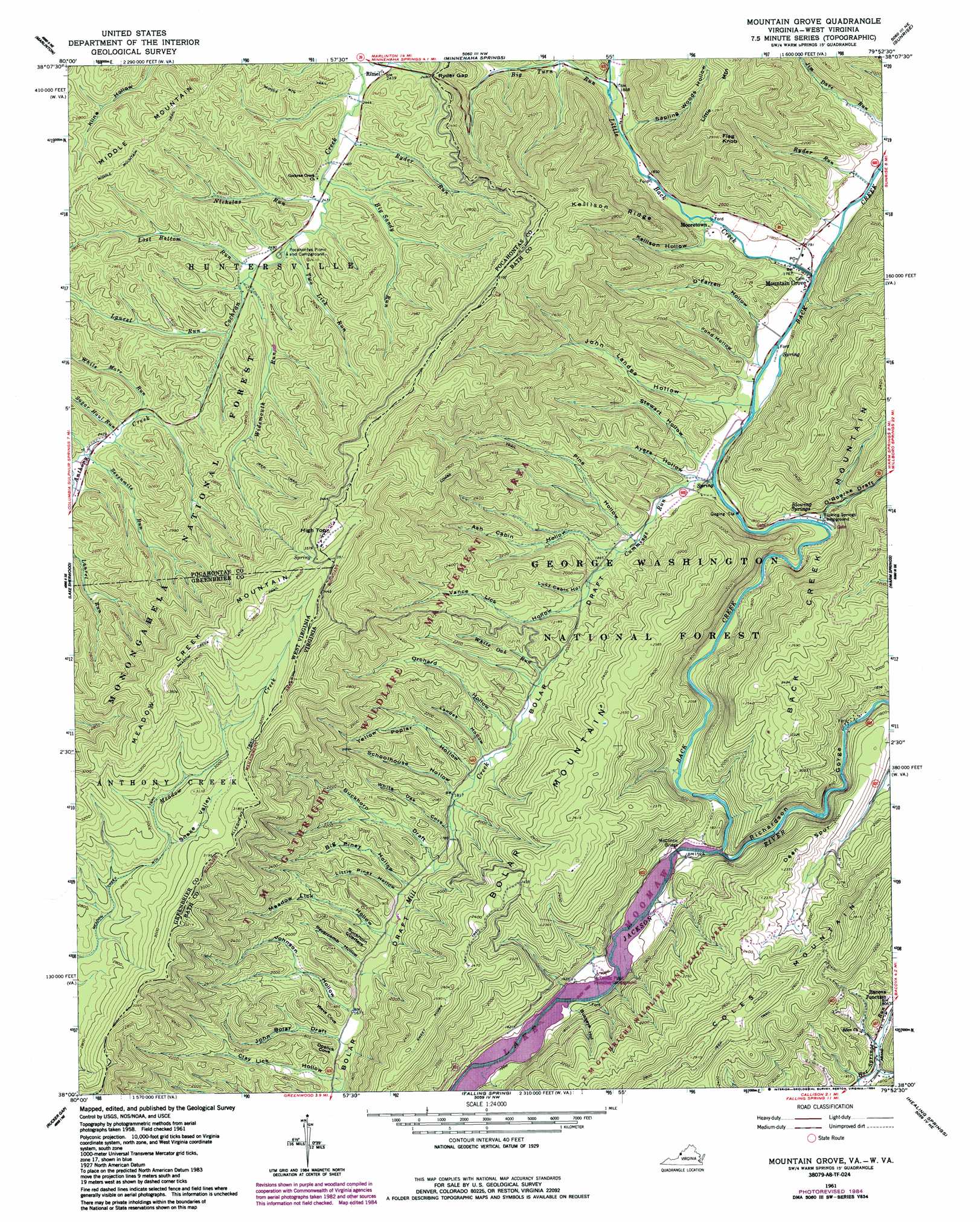
Mountain Grove Topo Map Virginia
To zoom in, hover over the map of Mountain Grove
USGS Topo Quad 38079a8 - 1:24,000 scale
| Topo Map Name: | Mountain Grove |
| USGS Topo Quad ID: | 38079a8 |
| Print Size: | ca. 21 1/4" wide x 27" high |
| Southeast Coordinates: | 38° N latitude / 79.875° W longitude |
| Map Center Coordinates: | 38.0625° N latitude / 79.9375° W longitude |
| U.S. States: | VA, WV |
| Filename: | o38079a8.jpg |
| Download Map JPG Image: | Mountain Grove topo map 1:24,000 scale |
| Map Type: | Topographic |
| Topo Series: | 7.5´ |
| Map Scale: | 1:24,000 |
| Source of Map Images: | United States Geological Survey (USGS) |
| Alternate Map Versions: |
Mountain Grove VA 1930 Download PDF Buy paper map Mountain Grove VA 1961, updated 1964 Download PDF Buy paper map Mountain Grove VA 1961, updated 1984 Download PDF Buy paper map Mountain Grove VA 1995, updated 1998 Download PDF Buy paper map Mountain Grove VA 2011 Download PDF Buy paper map Mountain Grove VA 2013 Download PDF Buy paper map Mountain Grove VA 2016 Download PDF Buy paper map |
| FStopo: | US Forest Service topo Mountain Grove is available: Download FStopo PDF Download FStopo TIF |
1:24,000 Topo Quads surrounding Mountain Grove
Woodrow |
Edray |
Clover Lick |
Paddy Knob |
Mustoe |
Hillsboro |
Marlinton |
Minnehaha Springs |
Sunrise |
Burnsville |
Denmar |
Lake Sherwood |
Mountain Grove |
Warm Springs |
Bath Alum |
Alvon |
Rucker Gap |
Falling Spring |
Healing Springs |
Nimrod Hall |
Jerrys Run |
Callaghan |
Covington |
Clifton Forge |
Longdale Furnace |
> Back to 38079a1 at 1:100,000 scale
> Back to 38078a1 at 1:250,000 scale
> Back to U.S. Topo Maps home
Mountain Grove topo map: Gazetteer
Mountain Grove: Bridges
McClintic Bridge elevation 486m 1594′Mountain Grove: Dams
South River Number 19 Dam elevation 599m 1965′Mountain Grove: Gaps
Ryder Gap elevation 760m 2493′Ryder Gap elevation 767m 2516′
Mountain Grove: Parks
TM Gathright Wildlife Management Area elevation 639m 2096′Mountain Grove: Populated Places
Mooretown elevation 563m 1847′Mountain Grove elevation 539m 1768′
Rimel elevation 748m 2454′
Shanklin (historical) elevation 515m 1689′
Mountain Grove: Ridges
Dean Spur elevation 681m 2234′Kellison Ridge elevation 872m 2860′
Mountain Grove: Springs
Blowing Springs elevation 519m 1702′Mountain Grove: Streams
Back Creek elevation 482m 1581′Big Sandy Run elevation 748m 2454′
Big Turn Run elevation 576m 1889′
Cummings Run elevation 522m 1712′
Hamilton Lick Run elevation 732m 2401′
Laurel Run elevation 766m 2513′
Laurel Run elevation 766m 2513′
Little Back Creek elevation 536m 1758′
Lost Bottom Run elevation 761m 2496′
Necholas Run elevation 752m 2467′
Ryder Run elevation 544m 1784′
Ryder Run elevation 745m 2444′
Sevenmile Run elevation 732m 2401′
Sugar Haul Run elevation 739m 2424′
Two Lick Run elevation 756m 2480′
White Mare Run elevation 746m 2447′
White Oak Run elevation 598m 1961′
Widemouth Run elevation 763m 2503′
Mountain Grove: Summits
Bolar Mountain elevation 822m 2696′Coles Mountain elevation 863m 2831′
Flagg Knob elevation 895m 2936′
High Top elevation 1111m 3645′
High Top elevation 1107m 3631′
Mountain Grove: Trails
Combs Trail elevation 775m 2542′Divide Trail elevation 825m 2706′
Sweet Acorn Trail elevation 772m 2532′
Mountain Grove: Valleys
Ash Cabin Hollow elevation 555m 1820′Ayers Hollow elevation 528m 1732′
Big Piney Hollow elevation 532m 1745′
Buckeye Hollow elevation 538m 1765′
Buckhorn Draft elevation 541m 1774′
Buckhorn Quarters elevation 518m 1699′
Clay Lick Hollow elevation 500m 1640′
Doelick Cove elevation 501m 1643′
John Bolar Draft elevation 502m 1646′
John Landes Hollow elevation 535m 1755′
Johnson Hollow elevation 509m 1669′
Kellison Hollow elevation 574m 1883′
Landes Hollow elevation 564m 1850′
Little Piney Hollow elevation 530m 1738′
Lucy Cabin Hollow elevation 575m 1886′
Meadow Lick Hollow elevation 525m 1722′
Meva Cove elevation 508m 1666′
O'Farrell Hollow elevation 540m 1771′
Orchard Hollow elevation 580m 1902′
O'Roarke Draft elevation 515m 1689′
Pine Hollow elevation 548m 1797′
Pond Hollow elevation 534m 1751′
Revercomb Hollow elevation 517m 1696′
Richardson Gorge elevation 496m 1627′
Ryder Hollow elevation 636m 2086′
Sapling Woods Hollow elevation 575m 1886′
Schoolhouse Hollow elevation 549m 1801′
Snake Valley elevation 883m 2896′
Stewart Hollow elevation 529m 1735′
Vance Lick Hollow elevation 584m 1916′
White Oak Cove elevation 545m 1788′
Yellow Poplar Hollow elevation 556m 1824′
Mountain Grove digital topo map on disk
Buy this Mountain Grove topo map showing relief, roads, GPS coordinates and other geographical features, as a high-resolution digital map file on DVD:
Western Virginia & Southern West Virginia
Buy digital topo maps: Western Virginia & Southern West Virginia