Alvon Topo Map West Virginia
To zoom in, hover over the map of Alvon
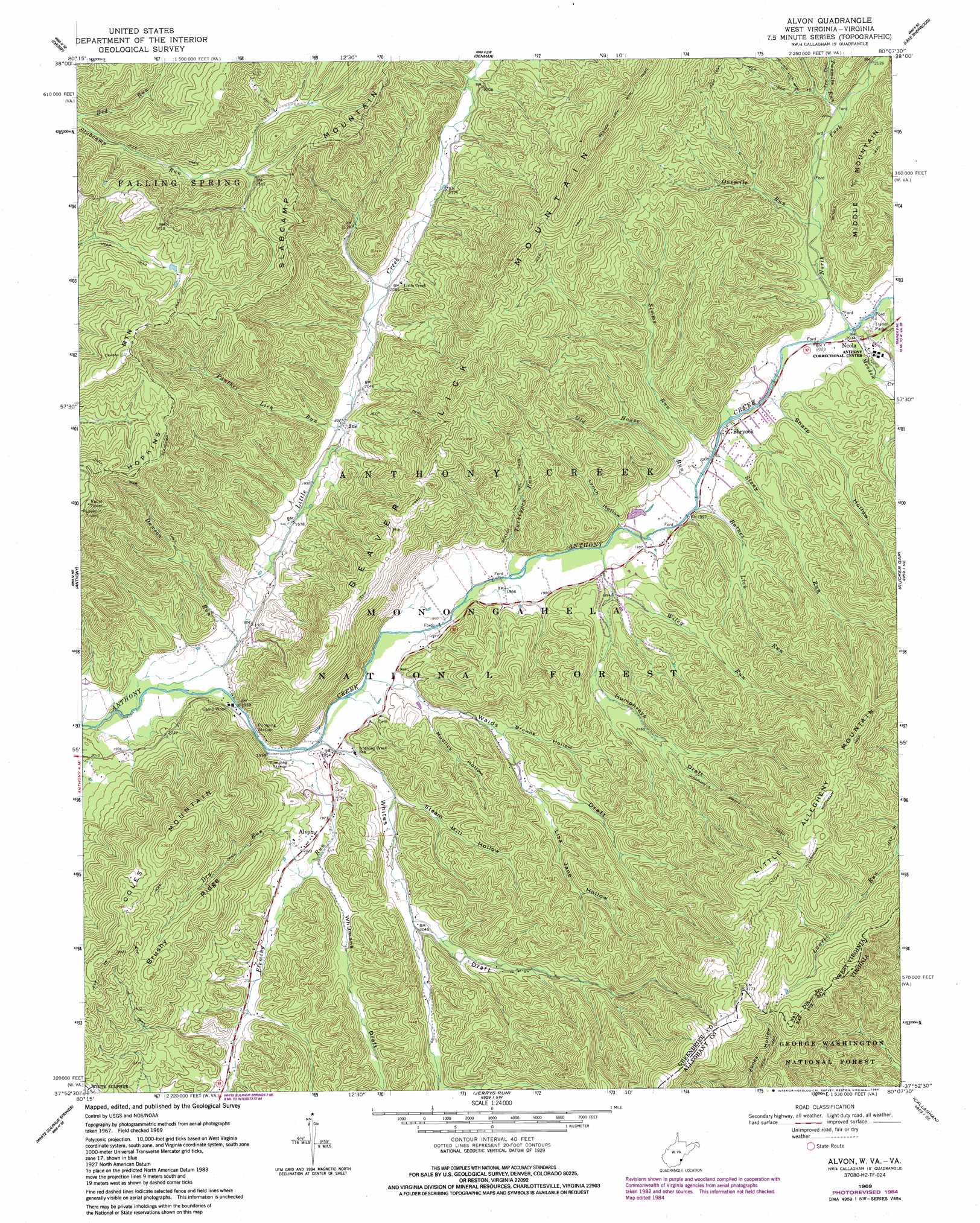
USGS Topo Quad 37080h2 - 1:24,000 scale
| Topo Map Name: | Alvon |
| USGS Topo Quad ID: | 37080h2 |
| Print Size: | ca. 21 1/4" wide x 27" high |
| Southeast Coordinates: | 37.875° N latitude / 80.125° W longitude |
| Map Center Coordinates: | 37.9375° N latitude / 80.1875° W longitude |
| U.S. States: | WV, VA |
| Filename: | o37080h2.jpg |
| Download Map JPG Image: | Alvon topo map 1:24,000 scale |
| Map Type: | Topographic |
| Topo Series: | 7.5´ |
| Map Scale: | 1:24,000 |
| Source of Map Images: | United States Geological Survey (USGS) |
| Alternate Map Versions: |
Alvon WV 1969, updated 1971 Download PDF Buy paper map Alvon WV 1969, updated 1976 Download PDF Buy paper map Alvon WV 1969, updated 1984 Download PDF Buy paper map Alvon WV 1995, updated 1998 Download PDF Buy paper map Alvon WV 2011 Download PDF Buy paper map Alvon WV 2014 Download PDF Buy paper map Alvon WV 2016 Download PDF Buy paper map |
| FStopo: | US Forest Service topo Alvon is available: Download FStopo PDF Download FStopo TIF |
1:24,000 Topo Quads surrounding Alvon
Fork Mountain |
Lobelia |
Hillsboro |
Marlinton |
Minnehaha Springs |
Trout |
Droop |
Denmar |
Lake Sherwood |
Mountain Grove |
Williamsburg |
Anthony |
Alvon |
Rucker Gap |
Falling Spring |
Lewisburg |
White Sulphur Springs |
Jerrys Run |
Callaghan |
Covington |
Ronceverte |
Glace |
Alleghany |
Jordan Mines |
Strom |
> Back to 37080e1 at 1:100,000 scale
> Back to 37080a1 at 1:250,000 scale
> Back to U.S. Topo Maps home
Alvon topo map: Gazetteer
Alvon: Parks
Neola Wildlife Management Area elevation 702m 2303′Alvon: Populated Places
Alvon elevation 611m 2004′Neola elevation 621m 2037′
Shryock elevation 612m 2007′
Sue elevation 616m 2020′
Alvon: Post Offices
Neola Post Office elevation 621m 2037′Alvon: Ridges
Brushy Ridge elevation 808m 2650′Alvon: Springs
Alvon Spring Number 1 elevation 599m 1965′Alvon Spring Number 3 elevation 599m 1965′
Alvon Spring Number 4 elevation 599m 1965′
Anthony Cave Spring elevation 658m 2158′
Alvon: Streams
Barnes Lick Run elevation 606m 1988′Dawson Run elevation 590m 1935′
Dry Run elevation 601m 1971′
Fleming Run elevation 588m 1929′
Lick Hollow Creek elevation 623m 2043′
Little Creek elevation 585m 1919′
Meadow Creek elevation 617m 2024′
Middle Fork Anthonys Creek elevation 617m 2024′
North Fork Anthony Creek elevation 618m 2027′
Old House Run elevation 606m 1988′
Onemile Run elevation 627m 2057′
Panther Lick Run elevation 614m 2014′
Simms Run elevation 609m 1998′
Stony Run elevation 607m 1991′
Turkeypen Run elevation 597m 1958′
Twomile Run elevation 641m 2103′
Wiley Run elevation 600m 1968′
Alvon: Summits
Coles Mountain elevation 936m 3070′Little Allegheny Mountain elevation 1016m 3333′
Alvon: Trails
Beaver Lick Mountain Trail elevation 978m 3208′Humphreys Draft Trail elevation 689m 2260′
Little Allegheny Mountain Trail elevation 969m 3179′
Slabcamp Trail elevation 723m 2372′
Slabcamp Trail elevation 899m 2949′
Alvon: Valleys
Browns Hollow elevation 613m 2011′Humphreys Draft elevation 608m 1994′
Lisa Jane Hollow elevation 629m 2063′
Lynch Hollow elevation 604m 1981′
Mudlick Hollow elevation 599m 1965′
Sharp Hollow elevation 613m 2011′
Steam Mill Hollow elevation 601m 1971′
Waids Draft elevation 594m 1948′
Whites Draft elevation 590m 1935′
Whitmans Draft elevation 601m 1971′
Alvon digital topo map on disk
Buy this Alvon topo map showing relief, roads, GPS coordinates and other geographical features, as a high-resolution digital map file on DVD:
Western Virginia & Southern West Virginia
Buy digital topo maps: Western Virginia & Southern West Virginia