Sherburne Topo Map Kentucky
To zoom in, hover over the map of Sherburne
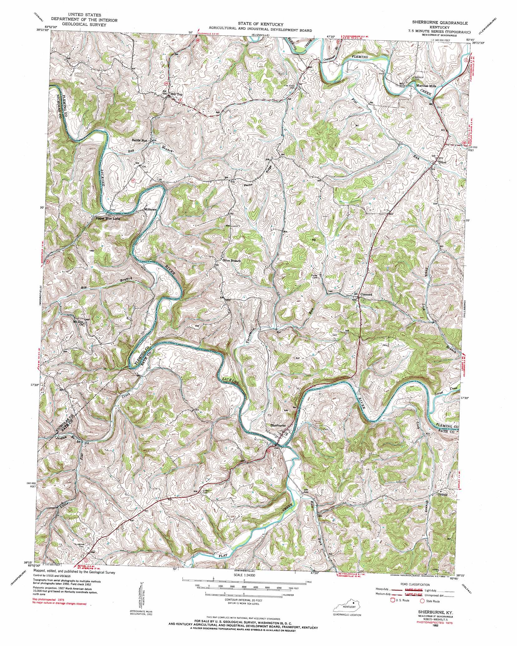
USGS Topo Quad 38083c7 - 1:24,000 scale
| Topo Map Name: | Sherburne |
| USGS Topo Quad ID: | 38083c7 |
| Print Size: | ca. 21 1/4" wide x 27" high |
| Southeast Coordinates: | 38.25° N latitude / 83.75° W longitude |
| Map Center Coordinates: | 38.3125° N latitude / 83.8125° W longitude |
| U.S. State: | KY |
| Filename: | o38083c7.jpg |
| Download Map JPG Image: | Sherburne topo map 1:24,000 scale |
| Map Type: | Topographic |
| Topo Series: | 7.5´ |
| Map Scale: | 1:24,000 |
| Source of Map Images: | United States Geological Survey (USGS) |
| Alternate Map Versions: |
Sherburne KY 1952, updated 1953 Download PDF Buy paper map Sherburne KY 2010 Download PDF Buy paper map Sherburne KY 2013 Download PDF Buy paper map Sherburne KY 2016 Download PDF Buy paper map |
1:24,000 Topo Quads surrounding Sherburne
Mount Olivet |
Sardis |
Mays Lick |
Orangeburg |
Tollesboro |
Piqua |
Cowan |
Elizaville |
Flemingsburg |
Burtonville |
Carlisle |
Moorefield |
Sherburne |
Hillsboro |
Plummers Landing |
North Middletown |
Sharpsburg |
Owingsville |
Colfax |
Farmers |
Sideview |
Mount Sterling |
Preston |
Olympia |
Salt Lick |
> Back to 38083a1 at 1:100,000 scale
> Back to 38082a1 at 1:250,000 scale
> Back to U.S. Topo Maps home
Sherburne topo map: Gazetteer
Sherburne: Bridges
Sherburne Bridge elevation 180m 590′The Iron Bridge elevation 219m 718′
Sherburne: Crossings
Licking River Ford elevation 187m 613′Sherburne: Populated Places
Battle Run elevation 194m 636′Concord elevation 257m 843′
Hill Top elevation 273m 895′
Milltown elevation 194m 636′
Olive Branch elevation 277m 908′
Pebble elevation 237m 777′
Peeble elevation 236m 774′
Sherburne elevation 194m 636′
South Sherburne elevation 199m 652′
Tilton elevation 256m 839′
Upper Blue Licks elevation 192m 629′
Sherburne: Post Offices
Balm Post Office (historical) elevation 255m 836′Battle Run Post Office (historical) elevation 199m 652′
Hill Top Post Office (historical) elevation 275m 902′
Martha Mills Post Office (historical) elevation 229m 751′
Pecks Ridge Post Office (historical) elevation 285m 935′
Peeble Post Office (historical) elevation 231m 757′
Sherburne Milles Post Office (historical) elevation 198m 649′
Sherburne: Ridges
Pecks Ridge elevation 293m 961′Sherburne: Streams
Big Branch elevation 182m 597′Craintown Branch elevation 219m 718′
East Fork Flat Creek elevation 188m 616′
Flat Creek elevation 182m 597′
Flat Run elevation 223m 731′
Jerdan Branch elevation 201m 659′
Lick Branch elevation 189m 620′
Little Flat Creek elevation 181m 593′
Locust Creek elevation 187m 613′
McGaha Branch elevation 199m 652′
Sap Branch elevation 181m 593′
Threemile Run elevation 180m 590′
Two Mile Run elevation 180m 590′
Sherburne digital topo map on disk
Buy this Sherburne topo map showing relief, roads, GPS coordinates and other geographical features, as a high-resolution digital map file on DVD:
Western Virginia & Southern West Virginia
Buy digital topo maps: Western Virginia & Southern West Virginia