Fisher Towers Topo Map Utah
To zoom in, hover over the map of Fisher Towers
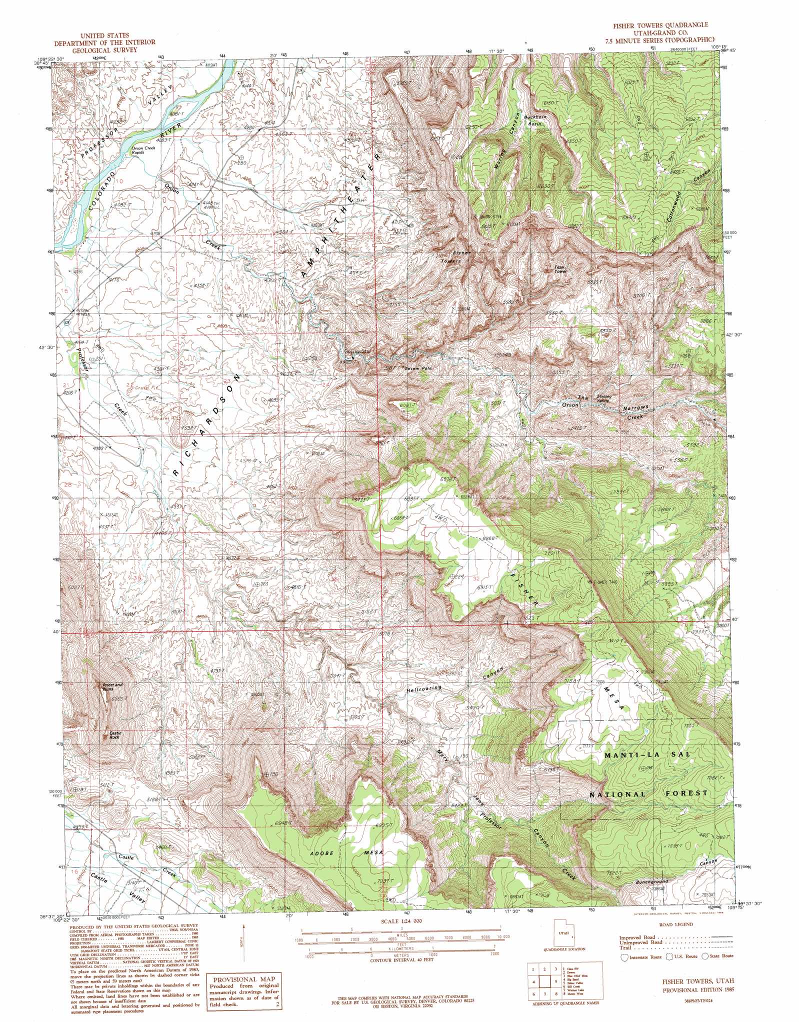
USGS Topo Quad 38109f3 - 1:24,000 scale
| Topo Map Name: | Fisher Towers |
| USGS Topo Quad ID: | 38109f3 |
| Print Size: | ca. 21 1/4" wide x 27" high |
| Southeast Coordinates: | 38.625° N latitude / 109.25° W longitude |
| Map Center Coordinates: | 38.6875° N latitude / 109.3125° W longitude |
| U.S. State: | UT |
| Filename: | o38109f3.jpg |
| Download Map JPG Image: | Fisher Towers topo map 1:24,000 scale |
| Map Type: | Topographic |
| Topo Series: | 7.5´ |
| Map Scale: | 1:24,000 |
| Source of Map Images: | United States Geological Survey (USGS) |
| Alternate Map Versions: |
Mt. Waas 3 NE UT 1954, updated 1956 Download PDF Buy paper map Fisher Towers UT 1985, updated 1986 Download PDF Buy paper map Fisher Towers UT 2001, updated 2004 Download PDF Buy paper map Fisher Towers UT 2011 Download PDF Buy paper map Fisher Towers UT 2014 Download PDF Buy paper map |
| FStopo: | US Forest Service topo Fisher Towers is available: Download FStopo PDF Download FStopo TIF |
1:24,000 Topo Quads surrounding Fisher Towers
Sagers Flat |
White House |
Cisco |
Big Triangle |
Marble Canyon |
Mollie Hogans |
Cisco Sw |
Dewey |
Blue Chief Mesa |
Steamboat Mesa |
The Windows Section |
Big Bend |
Fisher Towers |
Fisher Valley |
Dolores Point North |
Moab |
Rill Creek |
Warner Lake |
Mount Waas |
Dolores Point South |
Trough Springs Canyon |
Kane Springs |
Mount Tukuhnikivatz |
Mount Peale |
Buckeye Reservoir |
> Back to 38109e1 at 1:100,000 scale
> Back to 38108a1 at 1:250,000 scale
> Back to U.S. Topo Maps home
Fisher Towers topo map: Gazetteer
Fisher Towers: Basins
Buckhorn Basin elevation 1685m 5528′Richardson Amphitheater elevation 1292m 4238′
Fisher Towers: Parks
Fisher Towers Picnic Area elevation 1442m 4730′Fisher Towers: Pillars
Castle Rock elevation 1967m 6453′Fisher Towers elevation 1622m 5321′
Priest and Nuns elevation 1869m 6131′
Totem Pole elevation 1505m 4937′
Fisher Towers: Rapids
Onion Creek Rapids elevation 1234m 4048′Fisher Towers: Springs
Stinking Spring elevation 1523m 4996′Fisher Towers: Streams
Onion Creek elevation 1241m 4071′Fisher Towers: Summits
Fisher Mesa elevation 2260m 7414′Titan Tower elevation 1774m 5820′
Fisher Towers: Valleys
Bunchground Canyon elevation 2059m 6755′Hellroaring Canyon elevation 1491m 4891′
Mary Jane Canyon elevation 1499m 4917′
The Narrows elevation 1481m 4858′
Fisher Towers digital topo map on disk
Buy this Fisher Towers topo map showing relief, roads, GPS coordinates and other geographical features, as a high-resolution digital map file on DVD: