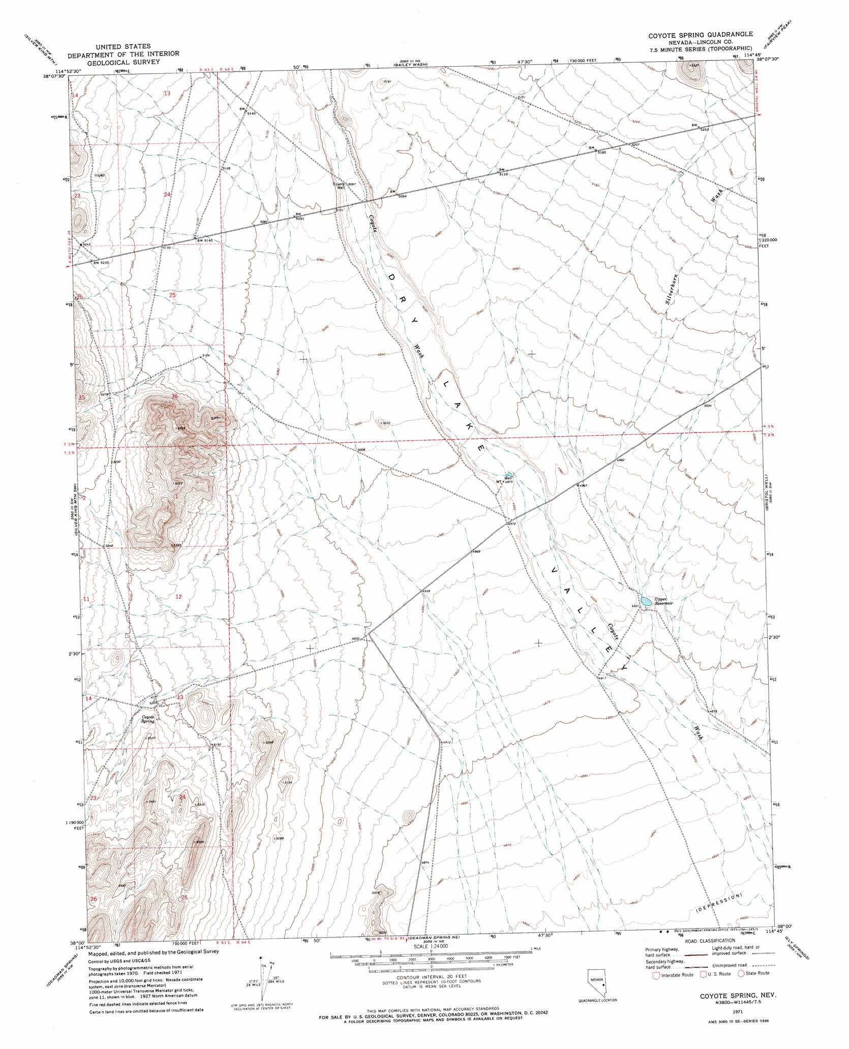
Coyote Spring Topo Map Nevada
To zoom in, hover over the map of Coyote Spring
USGS Topo Quad 38114a7 - 1:24,000 scale
| Topo Map Name: | Coyote Spring |
| USGS Topo Quad ID: | 38114a7 |
| Print Size: | ca. 21 1/4" wide x 27" high |
| Southeast Coordinates: | 38° N latitude / 114.75° W longitude |
| Map Center Coordinates: | 38.0625° N latitude / 114.8125° W longitude |
| U.S. State: | NV |
| Filename: | o38114a7.jpg |
| Download Map JPG Image: | Coyote Spring topo map 1:24,000 scale |
| Map Type: | Topographic |
| Topo Series: | 7.5´ |
| Map Scale: | 1:24,000 |
| Source of Map Images: | United States Geological Survey (USGS) |
| Alternate Map Versions: |
Coyote Spring NV 1971, updated 1973 Download PDF Buy paper map Coyote Spring NV 2012 Download PDF Buy paper map Coyote Spring NV 2014 Download PDF Buy paper map |
1:24,000 Topo Quads surrounding Coyote Spring
Gap Mountain |
Silver King Well |
Sidehill Pass |
Grassy Mountain |
Pony Springs |
Timber Mountain Pass Ne |
Silver King Mountain |
Bailey Wash |
Fairview Peak |
Bristol Range Ne |
Timber Mountain Pass East |
Silver King Mountain Sw |
Coyote Spring |
Bristol Well |
Bristol Range Se |
Weepah Spring |
Deadman Spring |
Deadman Spring Ne |
Ely Springs |
Highland Peak |
White River Narrows |
Wheatgrass Spring |
Deadman Spring Se |
The Bluffs |
Bennett Pass |
> Back to 38114a1 at 1:100,000 scale
> Back to 38114a1 at 1:250,000 scale
> Back to U.S. Topo Maps home
Coyote Spring topo map: Gazetteer
Coyote Spring: Populated Places
Coyote (historical) elevation 1592m 5223′Coyote Spring: Reservoirs
Bailey Knoll Reservoir elevation 1534m 5032′Bristol Reservoir elevation 1564m 5131′
Upper Reservoir elevation 1502m 4927′
Coyote Spring: Springs
Coyote Spring elevation 1546m 5072′Coyote Spring elevation 1596m 5236′
Stonewall Spring elevation 1593m 5226′
Coyote Spring: Streams
Cherry Creek elevation 1530m 5019′Silverhorn Wash elevation 1503m 4931′
Coyote Spring: Wells
A P W Well elevation 1515m 4970′Coyote Well elevation 1547m 5075′
Coyote Spring digital topo map on disk
Buy this Coyote Spring topo map showing relief, roads, GPS coordinates and other geographical features, as a high-resolution digital map file on DVD: