Blue Eagle Mountain Topo Map Nevada
To zoom in, hover over the map of Blue Eagle Mountain
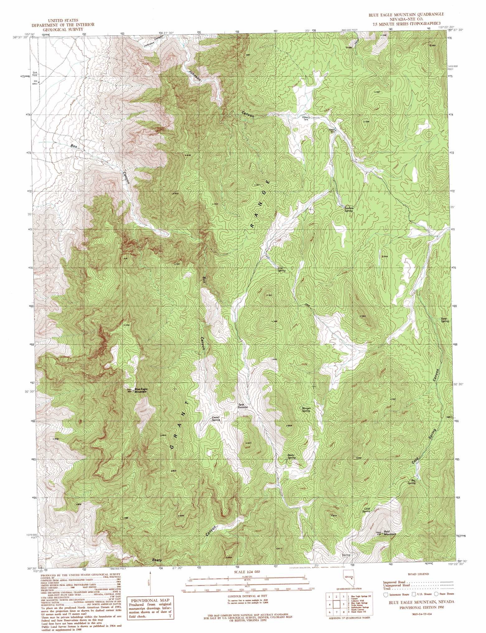
USGS Topo Quad 38115e4 - 1:24,000 scale
| Topo Map Name: | Blue Eagle Mountain |
| USGS Topo Quad ID: | 38115e4 |
| Print Size: | ca. 21 1/4" wide x 27" high |
| Southeast Coordinates: | 38.5° N latitude / 115.375° W longitude |
| Map Center Coordinates: | 38.5625° N latitude / 115.4375° W longitude |
| U.S. State: | NV |
| Filename: | o38115e4.jpg |
| Download Map JPG Image: | Blue Eagle Mountain topo map 1:24,000 scale |
| Map Type: | Topographic |
| Topo Series: | 7.5´ |
| Map Scale: | 1:24,000 |
| Source of Map Images: | United States Geological Survey (USGS) |
| Alternate Map Versions: |
Blue Eagle Mountain NV 1990, updated 1990 Download PDF Buy paper map Blue Eagle Mountain NV 2012 Download PDF Buy paper map Blue Eagle Mountain NV 2014 Download PDF Buy paper map |
1:24,000 Topo Quads surrounding Blue Eagle Mountain
Bradshaw Spring |
Duckwater Se |
White Pine Peak |
Currant Summit |
Douglas |
Meteorite Crater |
Blue Eagle Springs Ne |
Currant |
Callaway Well |
Moorman Spring Nw |
Blue Eagle Springs Sw |
Blue Eagle Springs |
Blue Eagle Mountain |
Wells Station |
Moorman Spring |
Christian Spring |
Bullwhacker Springs |
Heath Canyon |
Forest Home Ne |
Sunnyside Nw |
Crows Nest |
Troy Canyon |
Horse Spring Hills |
Forest Home |
Hot Creek Butte |
> Back to 38115e1 at 1:100,000 scale
> Back to 38114a1 at 1:250,000 scale
> Back to U.S. Topo Maps home
Blue Eagle Mountain topo map: Gazetteer
Blue Eagle Mountain: Springs
Andrew Spring elevation 2125m 6971′Beaty Spring elevation 2258m 7408′
Big Spring elevation 2330m 7644′
Box Canyon Spring elevation 2192m 7191′
Cazier Spring elevation 2380m 7808′
Cold Spring elevation 2389m 7837′
Log Spring elevation 2221m 7286′
Morgan Spring elevation 2318m 7604′
Seep Spring elevation 2115m 6938′
Blue Eagle Mountain: Summits
Bald Mountain elevation 2640m 8661′Blue Eagle Mountain elevation 2913m 9557′
Tank Summit elevation 2550m 8366′
Blue Eagle Mountain: Valleys
Box Canyon elevation 1534m 5032′Cold Spring Canyon elevation 2074m 6804′
Blue Eagle Mountain digital topo map on disk
Buy this Blue Eagle Mountain topo map showing relief, roads, GPS coordinates and other geographical features, as a high-resolution digital map file on DVD: