Galena Topo Map Maryland
To zoom in, hover over the map of Galena
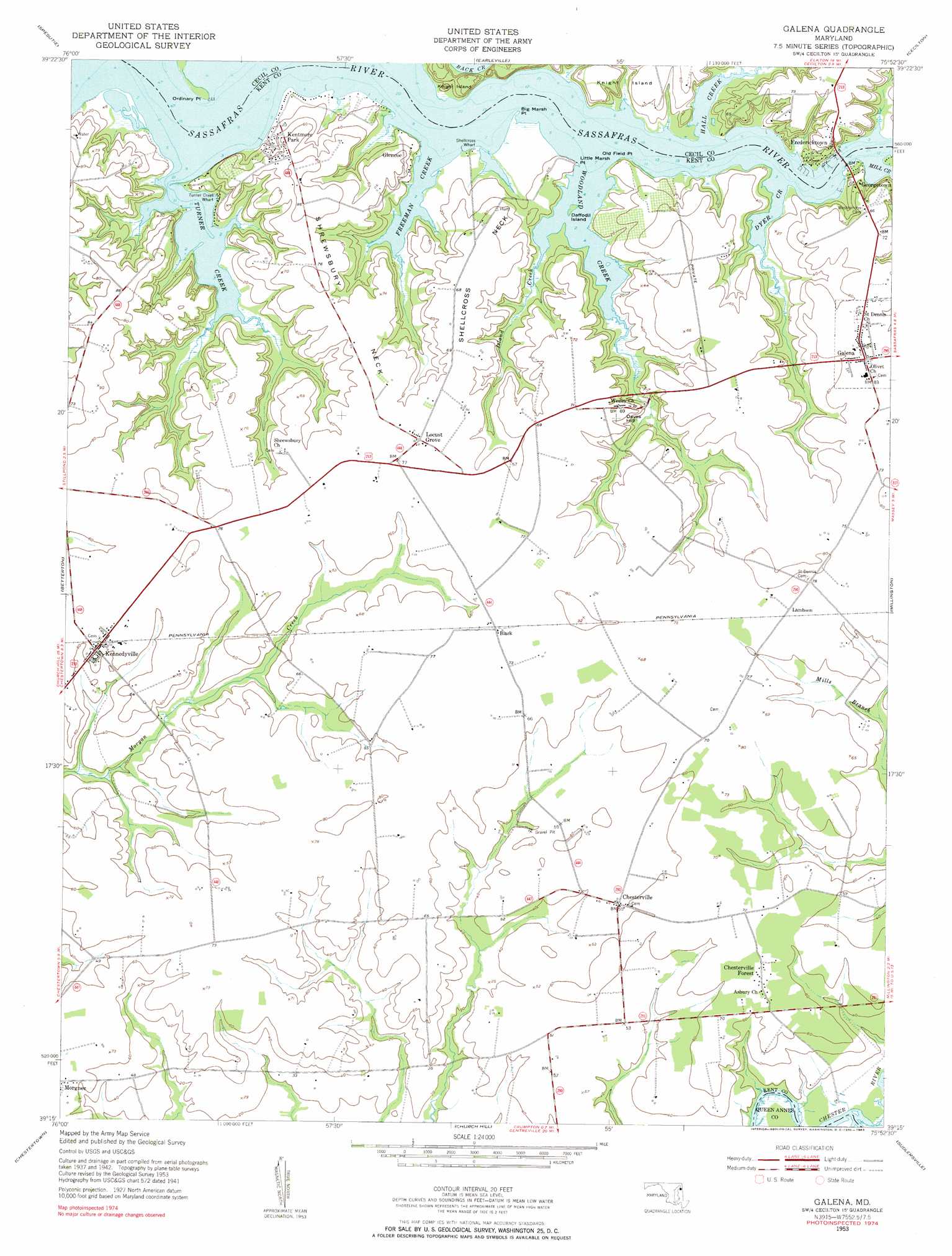
USGS Topo Quad 39075c8 - 1:24,000 scale
| Topo Map Name: | Galena |
| USGS Topo Quad ID: | 39075c8 |
| Print Size: | ca. 21 1/4" wide x 27" high |
| Southeast Coordinates: | 39.25° N latitude / 75.875° W longitude |
| Map Center Coordinates: | 39.3125° N latitude / 75.9375° W longitude |
| U.S. State: | MD |
| Filename: | o39075c8.jpg |
| Download Map JPG Image: | Galena topo map 1:24,000 scale |
| Map Type: | Topographic |
| Topo Series: | 7.5´ |
| Map Scale: | 1:24,000 |
| Source of Map Images: | United States Geological Survey (USGS) |
| Alternate Map Versions: |
Galena MD 1953, updated 1955 Download PDF Buy paper map Galena MD 1953, updated 1955 Download PDF Buy paper map Galena MD 1953, updated 1983 Download PDF Buy paper map Galena MD 2011 Download PDF Buy paper map Galena MD 2014 Download PDF Buy paper map Galena MD 2017 Download PDF Buy paper map |
1:24,000 Topo Quads surrounding Galena
Aberdeen |
Havre De Grace |
North East |
Elkton |
Saint Georges |
Perryman |
Spesutie |
Earleville |
Cecilton |
Middletown |
Hanesville |
Betterton |
Galena |
Millington |
Clayton |
Rock Hall |
Chestertown |
Church Hill |
Sudlersville |
Kenton |
Langford Creek |
Centreville |
Price |
Goldsboro |
Marydel |
> Back to 39075a1 at 1:100,000 scale
> Back to 39074a1 at 1:250,000 scale
> Back to U.S. Topo Maps home
Galena topo map: Gazetteer
Galena: Airports
Krastel Farms Airport elevation 18m 59′Galena: Capes
Big Marsh Point elevation 1m 3′Little Marsh Point elevation 6m 19′
Old Field Point elevation 1m 3′
Ordinary Point elevation 0m 0′
Penningtons Point elevation 1m 3′
Pig Point elevation 0m 0′
Ponds Bar elevation 0m 0′
Rattlesnake Point elevation 0m 0′
Shellcross Neck elevation 21m 68′
Shrewsbury Neck elevation 19m 62′
Galena: Islands
Daffodil Island elevation 0m 0′Galena: Parks
Turner Creek Landing Park elevation 6m 19′Turner Creek Park elevation 14m 45′
Galena: Populated Places
Brookewood Cove elevation 27m 88′Chesterville elevation 17m 55′
Chesterville Forest elevation 18m 59′
Cleavers Corner elevation 19m 62′
Dogwood Village elevation 18m 59′
Fredericktown elevation 10m 32′
Galena elevation 21m 68′
Georgetown elevation 10m 32′
Glencoe elevation 16m 52′
Goldsborough (historical) elevation 24m 78′
Harmony Corner elevation 23m 75′
Irelands Corner elevation 22m 72′
Kennedyville elevation 18m 59′
Kentmore Park elevation 12m 39′
Knocks Folly elevation 18m 59′
Lambson elevation 22m 72′
Locust Grove elevation 18m 59′
Galena: Post Offices
Chesterville Post Office (historical) elevation 17m 55′Galena Post Office elevation 22m 72′
Harmony Post Office (historical) elevation 23m 75′
Kennedyville Post Office elevation 18m 59′
Galena: Streams
Cow Creek elevation 14m 45′Dyer Creek elevation 0m 0′
Freeman Creek elevation 0m 0′
Hall Creek elevation 0m 0′
Island Creek elevation 10m 32′
Mill Creek elevation 0m 0′
Money Creek elevation 0m 0′
Turner Creek elevation 0m 0′
Woodland Creek elevation 0m 0′
Galena: Summits
Daves Hill elevation 19m 62′Galena digital topo map on disk
Buy this Galena topo map showing relief, roads, GPS coordinates and other geographical features, as a high-resolution digital map file on DVD:
Atlantic Coast (NY, NJ, PA, DE, MD, VA, NC)
Buy digital topo maps: Atlantic Coast (NY, NJ, PA, DE, MD, VA, NC)
 map DVD")