Phoenix Topo Map Maryland
To zoom in, hover over the map of Phoenix
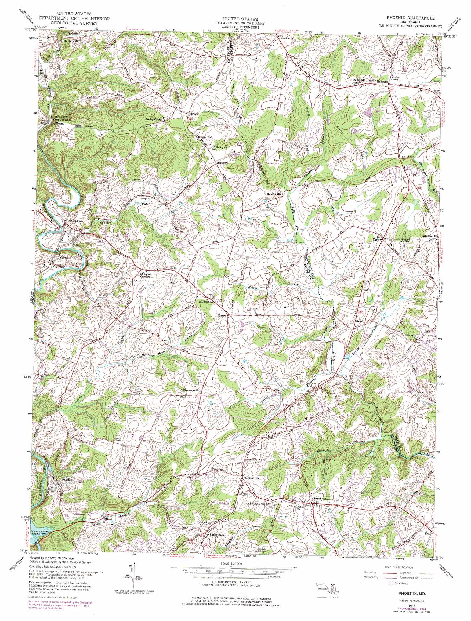
USGS Topo Quad 39076e5 - 1:24,000 scale
| Topo Map Name: | Phoenix |
| USGS Topo Quad ID: | 39076e5 |
| Print Size: | ca. 21 1/4" wide x 27" high |
| Southeast Coordinates: | 39.5° N latitude / 76.5° W longitude |
| Map Center Coordinates: | 39.5625° N latitude / 76.5625° W longitude |
| U.S. State: | MD |
| Filename: | o39076e5.jpg |
| Download Map JPG Image: | Phoenix topo map 1:24,000 scale |
| Map Type: | Topographic |
| Topo Series: | 7.5´ |
| Map Scale: | 1:24,000 |
| Source of Map Images: | United States Geological Survey (USGS) |
| Alternate Map Versions: |
Phoenix MD 1957, updated 1958 Download PDF Buy paper map Phoenix MD 1957, updated 1966 Download PDF Buy paper map Phoenix MD 1957, updated 1976 Download PDF Buy paper map Phoenix MD 1957, updated 1976 Download PDF Buy paper map Phoenix MD 2011 Download PDF Buy paper map Phoenix MD 2014 Download PDF Buy paper map Phoenix MD 2016 Download PDF Buy paper map |
1:24,000 Topo Quads surrounding Phoenix
Seven Valleys |
Glen Rock |
Stewartstown |
Airville |
Holtwood |
Lineboro |
New Freedom |
Norrisville |
Fawn Grove |
Delta |
Hampstead |
Hereford |
Phoenix |
Jarrettsville |
Bel Air |
Reisterstown |
Cockeysville |
Towson |
White Marsh |
Edgewood |
Ellicott City |
Baltimore West |
Baltimore East |
Middle River |
Gunpowder Neck |
> Back to 39076e1 at 1:100,000 scale
> Back to 39076a1 at 1:250,000 scale
> Back to U.S. Topo Maps home
Phoenix topo map: Gazetteer
Phoenix: Airports
Mrs Bozman Heliport elevation 189m 620′Phoenix: Dams
Briar Ridge Farm Pond Dam elevation 199m 652′Little Deer Creek Watershed Site Number 3 Dam elevation 202m 662′
Phoenix: Parks
Jarrettsville Park elevation 169m 554′Merryman Park elevation 102m 334′
Phoenix: Populated Places
Ascot Estates elevation 181m 593′Beckley Estates elevation 188m 616′
Blackhorse elevation 224m 734′
Blenheim Forest elevation 166m 544′
Blue Mount elevation 115m 377′
Brookfield elevation 185m 606′
Carroll Manor Ridge elevation 161m 528′
Charbonnet elevation 219m 718′
Cool Meadows Farms elevation 212m 695′
Cooperfield elevation 169m 554′
Corbett elevation 109m 357′
Corbett Hill Farms elevation 156m 511′
Cross Creek elevation 127m 416′
Dulaney Valley Estates elevation 162m 531′
Fairwood of Hunt Valley elevation 133m 436′
Fern Valley elevation 195m 639′
Fox Meadows elevation 185m 606′
Fox Meadows Purchase elevation 191m 626′
Fox Meadows Woods elevation 191m 626′
Fox Run elevation 182m 597′
Foxwood elevation 175m 574′
Glen Elyn elevation 164m 538′
Greenfield elevation 181m 593′
Hampshire elevation 185m 606′
Henrys Bridge elevation 184m 603′
Hess elevation 135m 442′
Hillendale Heights elevation 183m 600′
Houcks Mill elevation 147m 482′
Hunt Crest elevation 228m 748′
Hunters Mill elevation 129m 423′
Hurline Farms elevation 168m 551′
Jackson Ridge elevation 178m 583′
Jacksonville elevation 178m 583′
Kinhart Manor elevation 213m 698′
Locksley elevation 189m 620′
Locust Hill elevation 166m 544′
Madonna elevation 227m 744′
Manor elevation 178m 583′
Manor Brook elevation 145m 475′
Manor Fields elevation 181m 593′
Manor Glade elevation 155m 508′
Manor Glen elevation 177m 580′
Manor Ridge elevation 190m 623′
Manor View Farms elevation 188m 616′
Merrymans Mill elevation 166m 544′
Mill Run Estates elevation 177m 580′
Millgate elevation 188m 616′
Mission Ridge elevation 134m 439′
Monkton elevation 99m 324′
Monkton Farms elevation 147m 482′
My Ladys Manor Estates elevation 187m 613′
Old York Manor elevation 171m 561′
Patchwork Farms elevation 169m 554′
Phoenix elevation 96m 314′
Pleasant Prospect at Glen Elyn elevation 153m 501′
Quinn elevation 176m 577′
Shepperd elevation 210m 688′
Stockton elevation 195m 639′
Stockton Woods elevation 148m 485′
Sunnybrook elevation 170m 557′
Sutton Manor elevation 209m 685′
Sweet Air elevation 189m 620′
Sweet Air Manor elevation 173m 567′
Taylor elevation 178m 583′
The Fields of Four Corners elevation 174m 570′
The Highlands of Hunt Valley elevation 149m 488′
Troyer elevation 222m 728′
Vance Valley elevation 196m 643′
Wetherbee elevation 140m 459′
Wooddale Farms elevation 150m 492′
Phoenix: Post Offices
Monkton Post Office elevation 103m 337′Phoenix Post Office elevation 183m 600′
Phoenix: Reservoirs
Little Deer Creek Reservoir Number 3 elevation 202m 662′Phoenix: Streams
Charles Run elevation 105m 344′First Mine Branch elevation 102m 334′
Greene Branch elevation 73m 239′
Moy Burn elevation 137m 449′
My Ladys Manor Branch elevation 122m 400′
Nelson Branch elevation 132m 433′
Parker Branch elevation 118m 387′
Sawmill Branch elevation 111m 364′
Thornton Branch elevation 145m 475′
Yellow Branch elevation 118m 387′
Phoenix: Valleys
Verdant Valley elevation 122m 400′Phoenix digital topo map on disk
Buy this Phoenix topo map showing relief, roads, GPS coordinates and other geographical features, as a high-resolution digital map file on DVD:
Atlantic Coast (NY, NJ, PA, DE, MD, VA, NC)
Buy digital topo maps: Atlantic Coast (NY, NJ, PA, DE, MD, VA, NC)
 map DVD")