Thirteenmile Creek Topo Map Colorado
To zoom in, hover over the map of Thirteenmile Creek
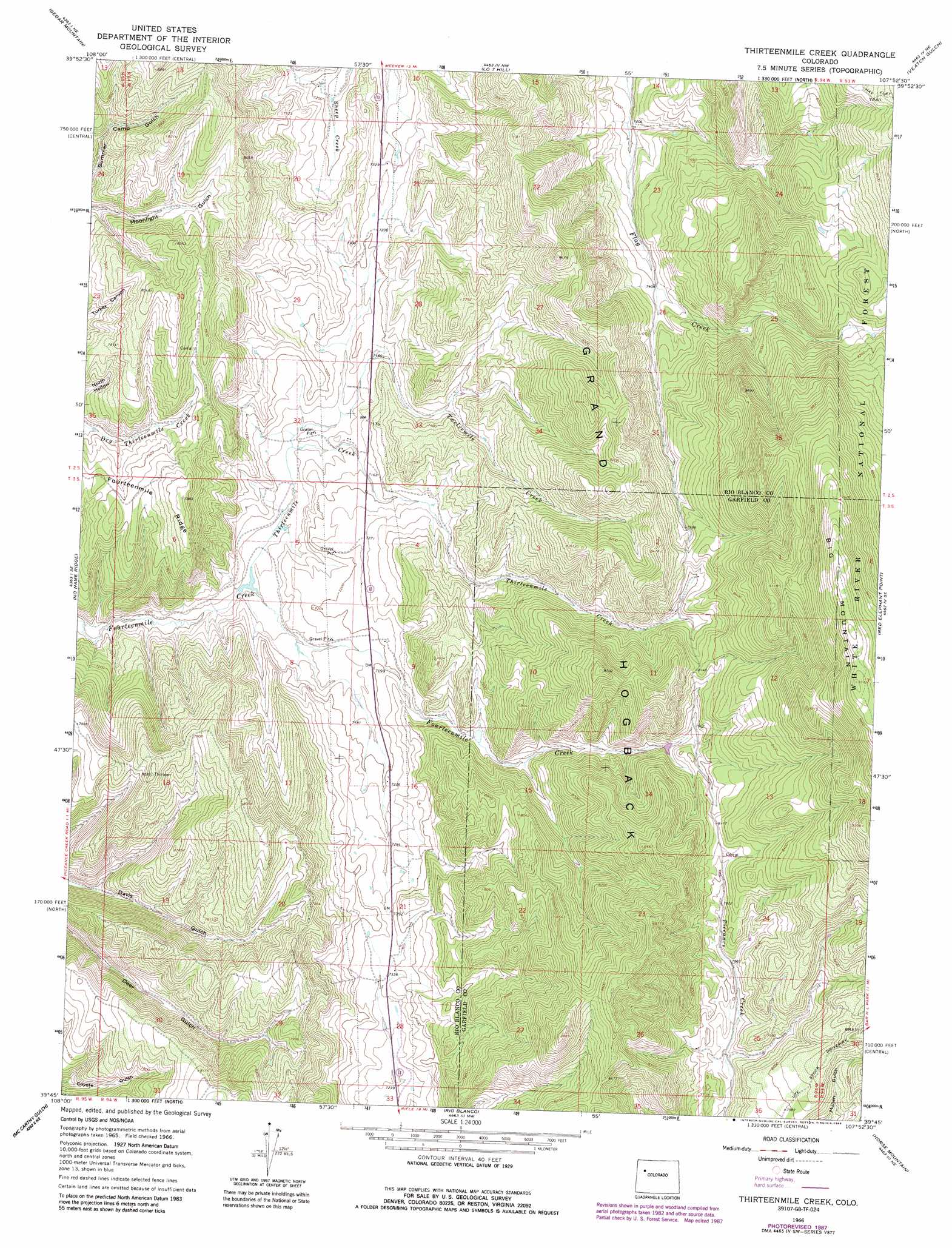
USGS Topo Quad 39107g8 - 1:24,000 scale
| Topo Map Name: | Thirteenmile Creek |
| USGS Topo Quad ID: | 39107g8 |
| Print Size: | ca. 21 1/4" wide x 27" high |
| Southeast Coordinates: | 39.75° N latitude / 107.875° W longitude |
| Map Center Coordinates: | 39.8125° N latitude / 107.9375° W longitude |
| U.S. State: | CO |
| Filename: | o39107g8.jpg |
| Download Map JPG Image: | Thirteenmile Creek topo map 1:24,000 scale |
| Map Type: | Topographic |
| Topo Series: | 7.5´ |
| Map Scale: | 1:24,000 |
| Source of Map Images: | United States Geological Survey (USGS) |
| Alternate Map Versions: |
Thirteenmile Creek CO 1966, updated 1969 Download PDF Buy paper map Thirteenmile Creek CO 1966, updated 1969 Download PDF Buy paper map Thirteenmile Creek CO 1966, updated 1976 Download PDF Buy paper map Thirteenmile Creek CO 1966, updated 1988 Download PDF Buy paper map Thirteenmile Creek CO 1966, updated 1988 Download PDF Buy paper map Thirteenmile Creek CO 2011 Download PDF Buy paper map Thirteenmile Creek CO 2013 Download PDF Buy paper map Thirteenmile Creek CO 2016 Download PDF Buy paper map |
| FStopo: | US Forest Service topo Thirteenmile Creek is available: Download FStopo PDF Download FStopo TIF |
1:24,000 Topo Quads surrounding Thirteenmile Creek
White River City |
Buckskin Point |
Meeker |
Rattlesnake Mesa |
Sawmill Mountain |
Greasewood Gulch |
Segar Mountain |
Lo 7 Hill |
Veatch Gulch |
Big Beaver Reservoir |
Jessup Gulch |
No Name Ridge |
Thirteenmile Creek |
Red Elephant Point |
Triangle Park |
Cutoff Gulch |
Mccarthy Gulch |
Rio Blanco |
Horse Mountain |
Rifle Falls |
Circle Dot Gulch |
Forked Gulch |
Anvil Points |
Rifle |
Silt |
> Back to 39107e1 at 1:100,000 scale
> Back to 39106a1 at 1:250,000 scale
> Back to U.S. Topo Maps home
Thirteenmile Creek topo map: Gazetteer
Thirteenmile Creek: Dams
West Miller Dam elevation 2257m 7404′Thirteenmile Creek: Reservoirs
West Miller Reservoir elevation 2257m 7404′Thirteenmile Creek: Streams
Thirteenmile Creek elevation 2148m 7047′Twelvemile Creek elevation 2167m 7109′
Thirteenmile Creek digital topo map on disk
Buy this Thirteenmile Creek topo map showing relief, roads, GPS coordinates and other geographical features, as a high-resolution digital map file on DVD: