Walti Hot Springs Topo Map Nevada
To zoom in, hover over the map of Walti Hot Springs
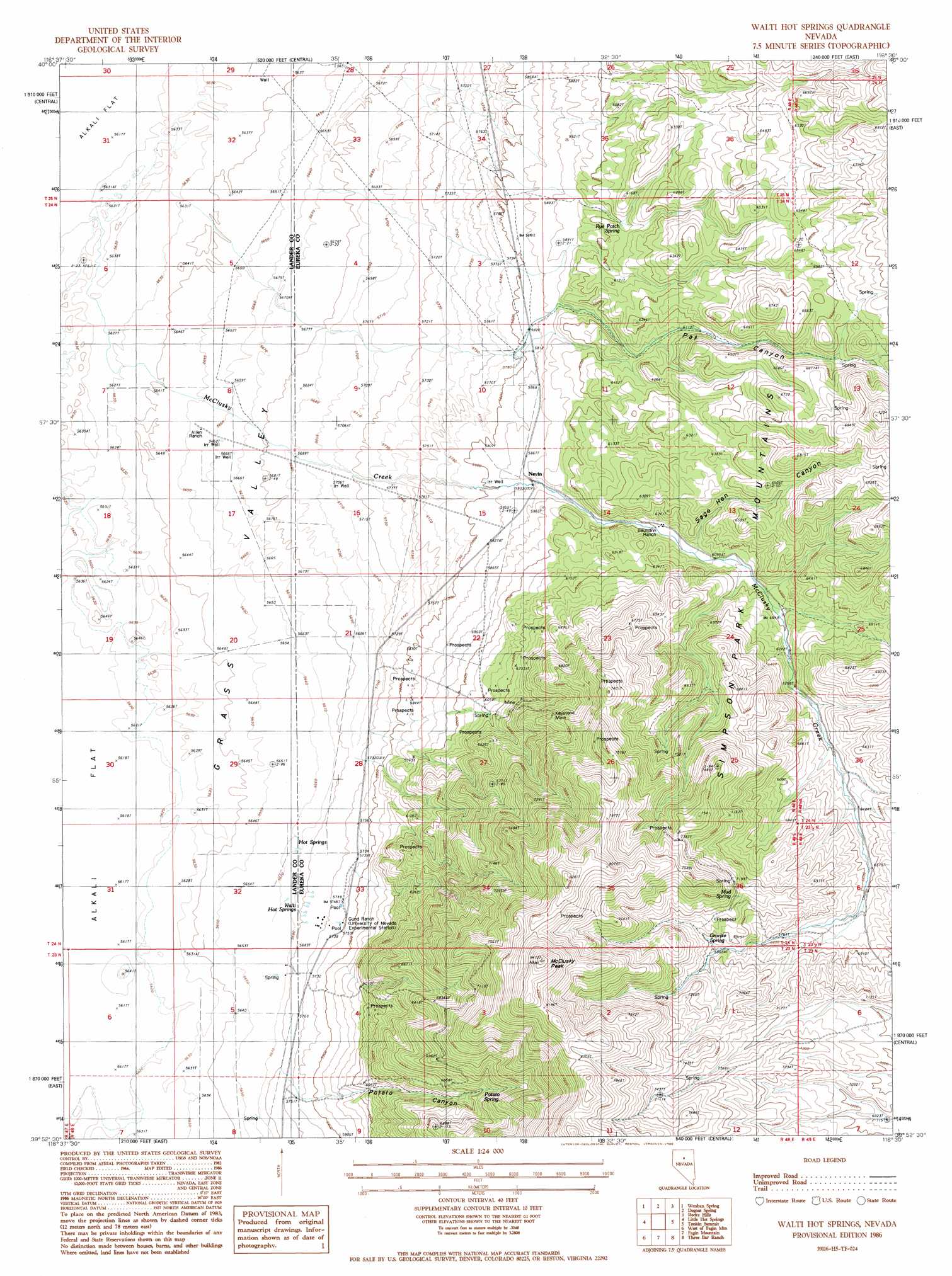
USGS Topo Quad 39116h5 - 1:24,000 scale
| Topo Map Name: | Walti Hot Springs |
| USGS Topo Quad ID: | 39116h5 |
| Print Size: | ca. 21 1/4" wide x 27" high |
| Southeast Coordinates: | 39.875° N latitude / 116.5° W longitude |
| Map Center Coordinates: | 39.9375° N latitude / 116.5625° W longitude |
| U.S. State: | NV |
| Filename: | o39116h5.jpg |
| Download Map JPG Image: | Walti Hot Springs topo map 1:24,000 scale |
| Map Type: | Topographic |
| Topo Series: | 7.5´ |
| Map Scale: | 1:24,000 |
| Source of Map Images: | United States Geological Survey (USGS) |
| Alternate Map Versions: |
Walti Hot Springs NV 1986, updated 1986 Download PDF Buy paper map Walti Hot Springs NV 2012 Download PDF Buy paper map Walti Hot Springs NV 2014 Download PDF Buy paper map |
1:24,000 Topo Quads surrounding Walti Hot Springs
Rocky Pass |
Cortez Canyon |
Cortez |
Buckhorn Mine |
Curlow Flat |
Wood Spring Canyon |
Wenban Spring |
Dugout Spring |
Rocky Hills |
Pete Hanson Creek |
Corral Canyon |
Little Hot Springs |
Walti Hot Springs |
Tonkin Summit |
Cooper Peak |
Cowboy Rest Creek |
West Of Fagin Mountain |
Fagin Mountain |
Three Bar Ranch |
Roberts Creek Mountain |
Grass Valley Ranch |
Salt Marsh Canyon |
Shagnasty |
Bartine Ranch Nw |
Bartine Ranch Ne |
> Back to 39116e1 at 1:100,000 scale
> Back to 39116a1 at 1:250,000 scale
> Back to U.S. Topo Maps home
Walti Hot Springs topo map: Gazetteer
Walti Hot Springs: Mines
Keystone Mine elevation 2067m 6781′Walti Hot Springs: Populated Places
Keystone (historical) elevation 1873m 6145′Nevin (historical) elevation 1793m 5882′
Walti Hot Springs: Post Offices
Keystone Post Office (historical) elevation 1873m 6145′Nevins Post Office (historical) elevation 1793m 5882′
Walti Hot Springs: Ranges
Simpson Park Mountains elevation 2304m 7559′Walti Hot Springs: Springs
Granite Spring elevation 2129m 6984′Mud Spring elevation 2103m 6899′
Potato Spring elevation 2048m 6719′
Rye Patch Spring elevation 1834m 6017′
Sage Hen Spring elevation 2281m 7483′
Walti Hot Springs elevation 1756m 5761′
Walti Hot Springs: Streams
McClusky Creek elevation 1733m 5685′Walti Hot Springs: Summits
McClusky Peak elevation 2565m 8415′Walti Hot Springs: Valleys
Pat Canyon elevation 1774m 5820′Potato Canyon elevation 1756m 5761′
Sage Hen Canyon elevation 1878m 6161′
Walti Hot Springs digital topo map on disk
Buy this Walti Hot Springs topo map showing relief, roads, GPS coordinates and other geographical features, as a high-resolution digital map file on DVD: