Mystic Topo Map Iowa
To zoom in, hover over the map of Mystic
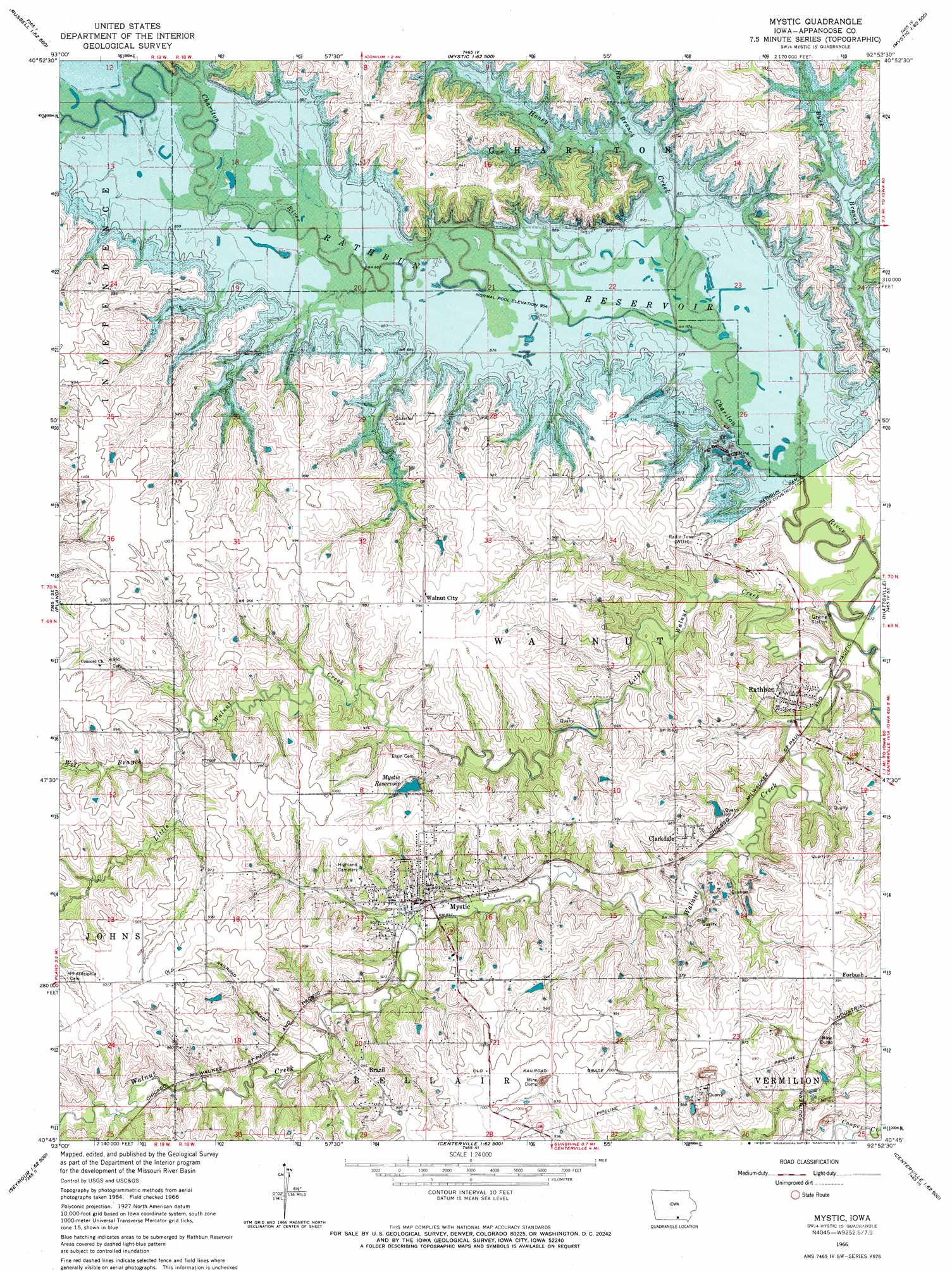
USGS Topo Quad 40092g8 - 1:24,000 scale
| Topo Map Name: | Mystic |
| USGS Topo Quad ID: | 40092g8 |
| Print Size: | ca. 21 1/4" wide x 27" high |
| Southeast Coordinates: | 40.75° N latitude / 92.875° W longitude |
| Map Center Coordinates: | 40.8125° N latitude / 92.9375° W longitude |
| U.S. State: | IA |
| Filename: | o40092g8.jpg |
| Download Map JPG Image: | Mystic topo map 1:24,000 scale |
| Map Type: | Topographic |
| Topo Series: | 7.5´ |
| Map Scale: | 1:24,000 |
| Source of Map Images: | United States Geological Survey (USGS) |
| Alternate Map Versions: |
Mystic IA 1966, updated 1967 Download PDF Buy paper map Mystic IA 2010 Download PDF Buy paper map Mystic IA 2013 Download PDF Buy paper map Mystic IA 2015 Download PDF Buy paper map |
1:24,000 Topo Quads surrounding Mystic
Olmitz |
Wales |
Hiteman |
Albia |
Avery |
Russell |
Melrose |
Iconium |
Moravia |
Blakesburg |
Confidence |
Plano |
Mystic |
Hiattsville |
Unionville |
Seymour West |
Seymour East |
Centerville West |
Centerville East |
Moulton |
Saint John |
Lake Thunderhead |
Mendota |
Omaha |
Coatsville |
> Back to 40092e1 at 1:100,000 scale
> Back to 40092a1 at 1:250,000 scale
> Back to U.S. Topo Maps home
Mystic topo map: Gazetteer
Mystic: Parks
Honey Creek State Park elevation 296m 971′Island View Park elevation 276m 905′
Prairie Ridge Park elevation 276m 905′
Rolling Cove Park elevation 293m 961′
Mystic: Populated Places
Brazil elevation 303m 994′Clarkdale elevation 290m 951′
Diamond elevation 288m 944′
Forbush elevation 299m 980′
Mystic elevation 274m 898′
Rathbun elevation 286m 938′
Walnut City elevation 302m 990′
Mystic: Post Offices
Brazil Post Office (historical) elevation 303m 994′Calhoun Post Office (historical) elevation 301m 987′
Clarkdale Post Office (historical) elevation 290m 951′
Diamond Post Office (historical) elevation 288m 944′
Forbush Post Office (historical) elevation 299m 980′
Mystic Post Office elevation 274m 898′
Rathbun Post Office (historical) elevation 286m 938′
Walnut City Post Office (historical) elevation 302m 990′
Mystic: Reservoirs
Mystic Reservoir elevation 288m 944′Rathbun Lake elevation 276m 905′
Mystic: Streams
Buck Branch elevation 259m 849′Ham Branch elevation 276m 905′
Honey Creek elevation 276m 905′
Little Walnut Creek elevation 258m 846′
Walnut Creek elevation 259m 849′
Wolf Branch elevation 283m 928′
Mystic digital topo map on disk
Buy this Mystic topo map showing relief, roads, GPS coordinates and other geographical features, as a high-resolution digital map file on DVD: