Buffalo Springs Ranch Topo Map Colorado
To zoom in, hover over the map of Buffalo Springs Ranch
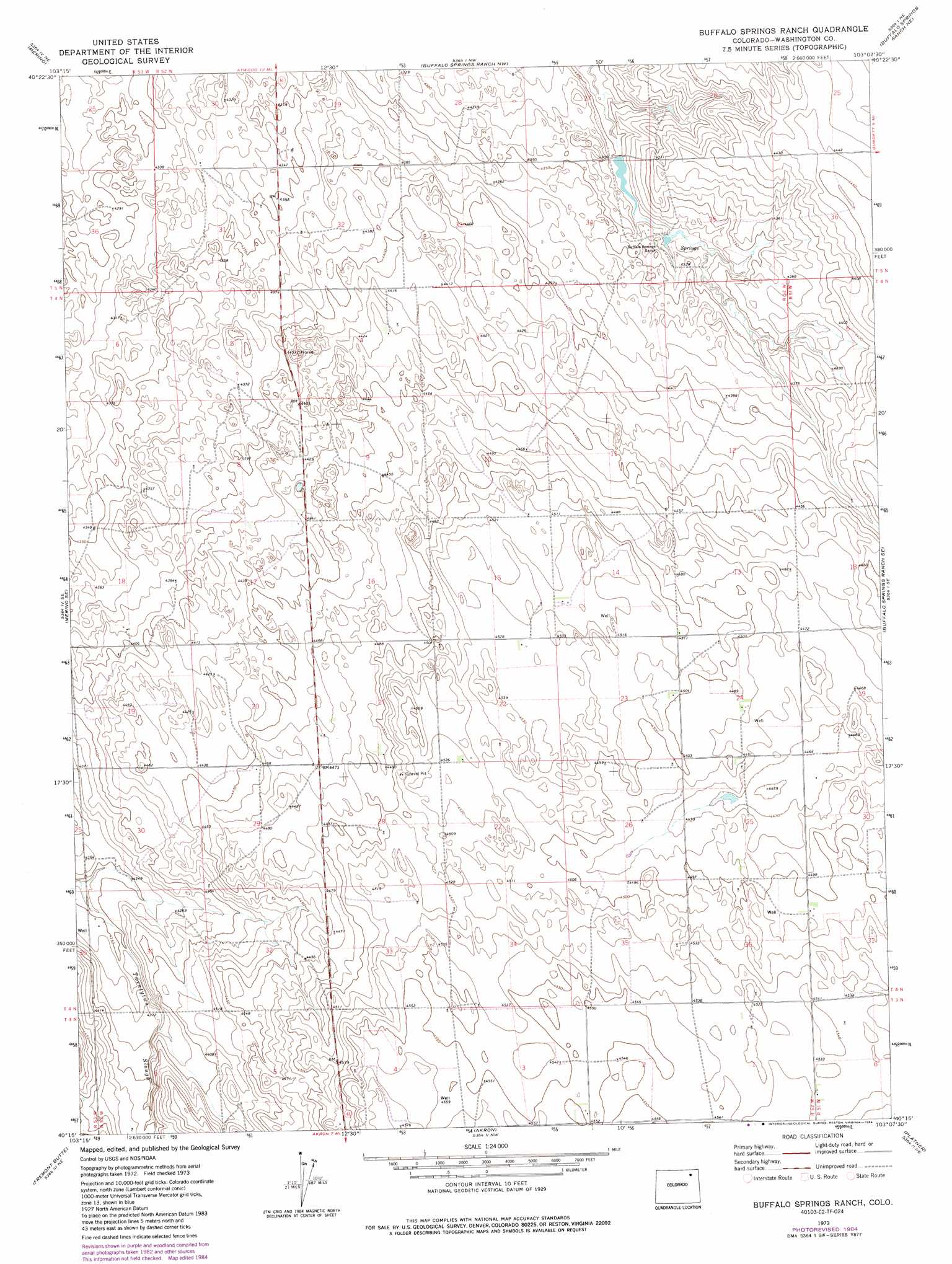
USGS Topo Quad 40103c2 - 1:24,000 scale
| Topo Map Name: | Buffalo Springs Ranch |
| USGS Topo Quad ID: | 40103c2 |
| Print Size: | ca. 21 1/4" wide x 27" high |
| Southeast Coordinates: | 40.25° N latitude / 103.125° W longitude |
| Map Center Coordinates: | 40.3125° N latitude / 103.1875° W longitude |
| U.S. State: | CO |
| Filename: | o40103c2.jpg |
| Download Map JPG Image: | Buffalo Springs Ranch topo map 1:24,000 scale |
| Map Type: | Topographic |
| Topo Series: | 7.5´ |
| Map Scale: | 1:24,000 |
| Source of Map Images: | United States Geological Survey (USGS) |
| Alternate Map Versions: |
Buffalo Springs Ranch CO 1973, updated 1976 Download PDF Buy paper map Buffalo Springs Ranch CO 1973, updated 1976 Download PDF Buy paper map Buffalo Springs Ranch CO 1973, updated 1984 Download PDF Buy paper map Buffalo Springs Ranch CO 1973, updated 1984 Download PDF Buy paper map Buffalo Springs Ranch CO 2010 Download PDF Buy paper map Buffalo Springs Ranch CO 2013 Download PDF Buy paper map Buffalo Springs Ranch CO 2016 Download PDF Buy paper map |
1:24,000 Topo Quads surrounding Buffalo Springs Ranch
Willard |
Atwood |
Sterling South |
Reiradon Hill |
Leroy |
Messex |
Merino |
Buffalo Springs Ranch Nw |
Buffalo Springs Ranch Ne |
Glacken Hill |
Merino Sw |
Merino Se |
Buffalo Springs Ranch |
Buffalo Springs Ranch Se |
Burdett |
Pinneo |
Fremont Butte |
Akron |
Platner |
Otis |
Rago |
Pinneo Se |
Akron Sw |
Akron Se |
Snyder Lake |
> Back to 40103a1 at 1:100,000 scale
> Back to 40102a1 at 1:250,000 scale
> Back to U.S. Topo Maps home
Buffalo Springs Ranch topo map: Gazetteer
Buffalo Springs Ranch: Dams
Buffalo Creek Dam elevation 1313m 4307′Buffalo Springs Ranch: Reservoirs
Buffalo Creek Reservoir elevation 1313m 4307′Buffalo Springs Ranch digital topo map on disk
Buy this Buffalo Springs Ranch topo map showing relief, roads, GPS coordinates and other geographical features, as a high-resolution digital map file on DVD: