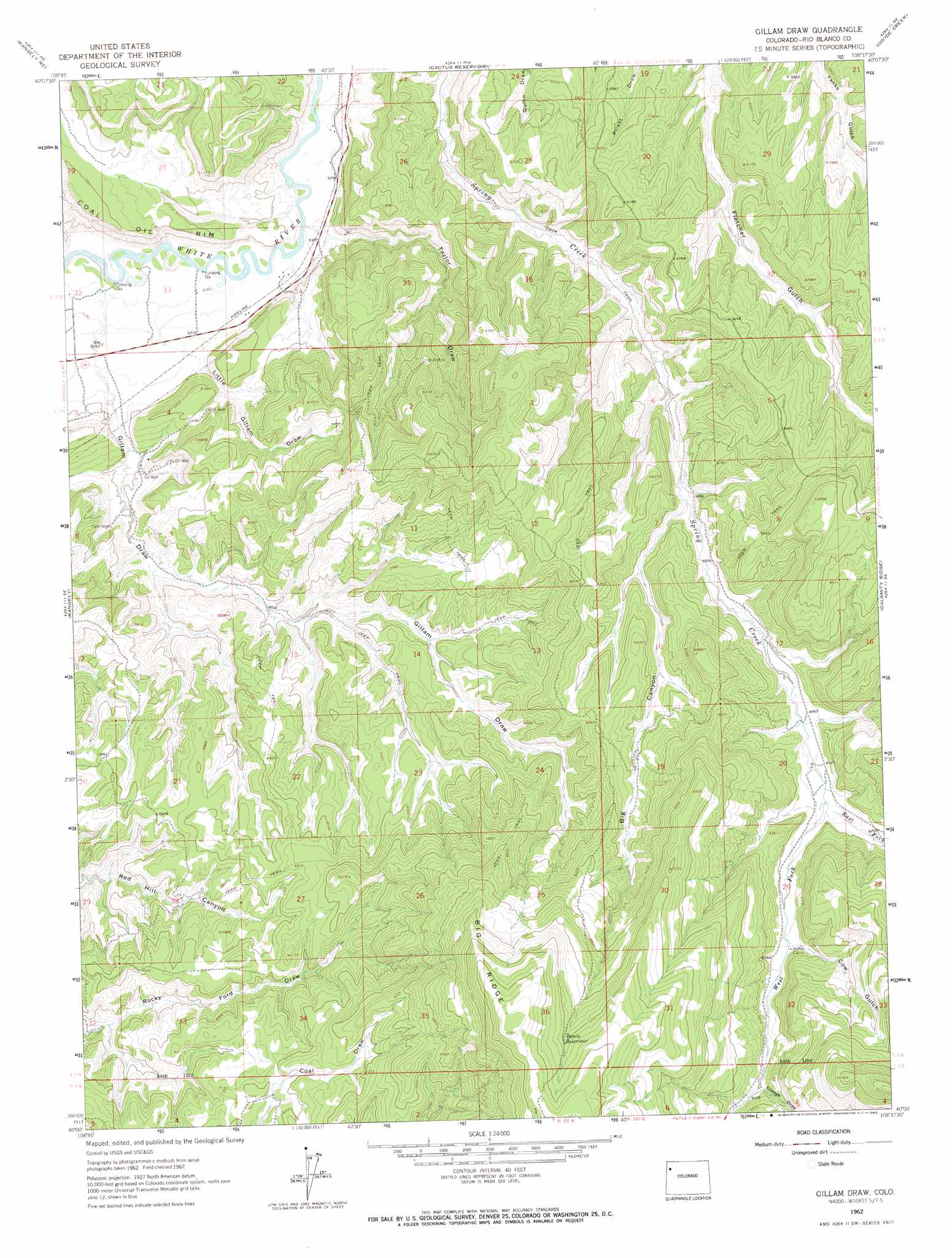
Gillam Draw Topo Map Colorado
To zoom in, hover over the map of Gillam Draw
USGS Topo Quad 40108a6 - 1:24,000 scale
| Topo Map Name: | Gillam Draw |
| USGS Topo Quad ID: | 40108a6 |
| Print Size: | ca. 21 1/4" wide x 27" high |
| Southeast Coordinates: | 40° N latitude / 108.625° W longitude |
| Map Center Coordinates: | 40.0625° N latitude / 108.6875° W longitude |
| U.S. State: | CO |
| Filename: | o40108a6.jpg |
| Download Map JPG Image: | Gillam Draw topo map 1:24,000 scale |
| Map Type: | Topographic |
| Topo Series: | 7.5´ |
| Map Scale: | 1:24,000 |
| Source of Map Images: | United States Geological Survey (USGS) |
| Alternate Map Versions: |
Gillam Draw CO 1962, updated 1965 Download PDF Buy paper map Gillam Draw CO 2010 Download PDF Buy paper map Gillam Draw CO 2013 Download PDF Buy paper map Gillam Draw CO 2016 Download PDF Buy paper map |
1:24,000 Topo Quads surrounding Gillam Draw
Plug Hat Rock |
Lazy Y Point |
Skull Creek |
M F Mountain |
Elk Springs |
Mellen Hill |
Rangely Ne |
Cactus Reservoir |
Divide Creek |
Rough Gulch |
Banty Point |
Rangely |
Gillam Draw |
Calamity Ridge |
Barcus Creek |
Banta Ridge |
Water Canyon |
Philadelphia Creek |
Sagebrush Hill |
Wolf Ridge |
Texas Creek |
Texas Mountain |
White Coyote Draw |
Black Cabin Gulch |
Yankee Gulch |
> Back to 40108a1 at 1:100,000 scale
> Back to 40108a1 at 1:250,000 scale
> Back to U.S. Topo Maps home
Gillam Draw topo map: Gazetteer
Gillam Draw: Mines
Hefley Mine elevation 1714m 5623′Gillam Draw: Reservoirs
Basin Reservoir elevation 2194m 7198′Gillam Draw: Streams
East Fork Spring Creek elevation 1860m 6102′West Fork Spring Creek elevation 1860m 6102′
Gillam Draw: Valleys
Big Canyon elevation 1802m 5912′Cow Gulch elevation 1912m 6272′
Elledge Draw elevation 1963m 6440′
Gillam Draw elevation 1625m 5331′
Little Gillam Draw elevation 1633m 5357′
Taylor Draw elevation 1621m 5318′
Gillam Draw digital topo map on disk
Buy this Gillam Draw topo map showing relief, roads, GPS coordinates and other geographical features, as a high-resolution digital map file on DVD: