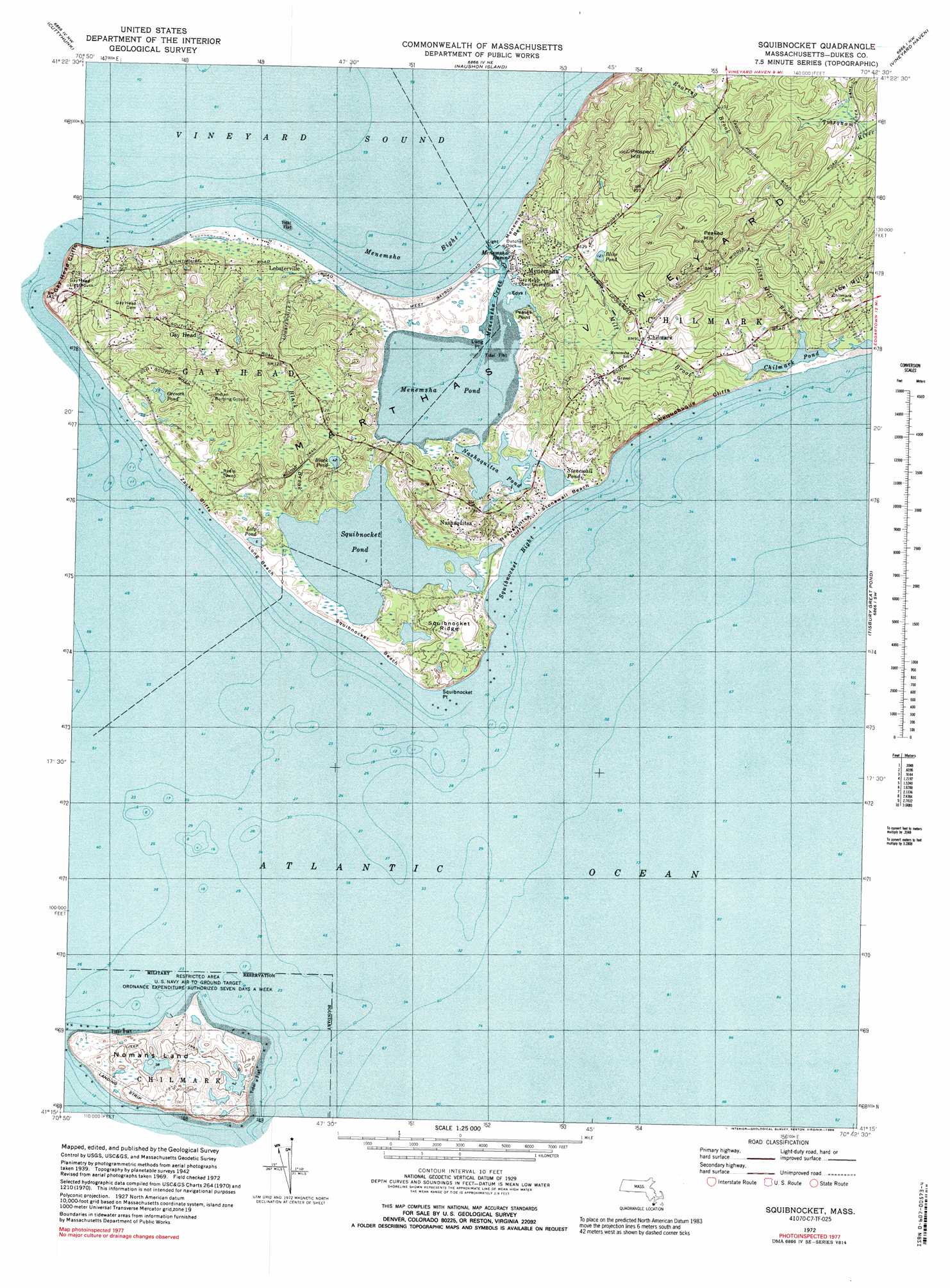
Squibnocket Topo Map Massachusetts
To zoom in, hover over the map of Squibnocket
USGS Topo Quad 41070c6 - 1:25,000 scale
| Topo Map Name: | Squibnocket |
| USGS Topo Quad ID: | 41070c6 |
| Print Size: | ca. 21 1/4" wide x 27" high |
| Southeast Coordinates: | 41.25° N latitude / 70.625° W longitude |
| Map Center Coordinates: | 41.3125° N latitude / 70.6875° W longitude |
| U.S. State: | MA |
| Filename: | l41070c6.jpg |
| Download Map JPG Image: | Squibnocket topo map 1:25,000 scale |
| Map Type: | Topographic |
| Topo Series: | 7.5´ |
| Map Scale: | 1:25,000 |
| Source of Map Images: | United States Geological Survey (USGS) |
| Alternate Map Versions: |
1:24,000 Topo Quads surrounding Squibnocket
New Bedford South |
Sconticut Neck |
Woods Hole |
Falmouth |
Cotuit |
Cuttyhunk |
Nauson Island |
Vineyard Haven |
||
Squibnocket |
Tisbury Great Pond |
Edgartown |
||
> Back to 41070a1 at 1:100,000 scale
> Back to 41070a1 at 1:250,000 scale
> Back to U.S. Topo Maps home
Squibnocket topo map: Gazetteer
Squibnocket: Bays
Deep Bottom Cove elevation 1m 3′Gilberts Cove elevation -3m -10′
Long Cove elevation -8m -27′
Middle Point Cove elevation 1m 3′
Muddy Cove elevation 0m 0′
Pear Tree Cove elevation 1m 3′
Short Cove elevation -8m -27′
Thumb Cove elevation 1m 3′
Tiah Cove elevation 0m 0′
Town Cove elevation 0m 0′
Wades Cove elevation 1m 3′
Squibnocket: Beaches
Lucy Vincent Beach elevation -3m -10′Squibnocket: Capes
Allen Point elevation -3m -10′Cobbs Point elevation -3m -10′
Flat Point elevation 2m 6′
Long Point elevation -3m -10′
Long Point (historical) elevation 6m 19′
Plum Bush Point elevation 0m 0′
Squibnocket: Cliffs
Wequobsque Cliffs elevation -3m -10′Squibnocket: Lakes
Black Point Pond elevation -3m -10′Chilmark Pond elevation 0m 0′
Homer Pond elevation -8m -27′
Quenames Cove elevation 0m 0′
Tisbury Great Pond elevation 0m 0′
Tississa Pond elevation 7m 22′
Squibnocket: Populated Places
Chilmark elevation 22m 72′Nabs Corner elevation 9m 29′
Quansoo elevation 4m 13′
Tississa elevation 2m 6′
Squibnocket: Post Offices
Chilmark Post Office elevation 23m 75′Squibnocket Post Office (historical) elevation 16m 52′
Squibnocket: Streams
Fulling Mill Brook elevation -3m -10′Mill Brook elevation -3m -10′
Tiasquam River elevation -4m -14′
Squibnocket: Summits
Abel Hill elevation 26m 85′Peaked Hill elevation 83m 272′
Prospect Hill elevation 78m 255′
Ridge Hill elevation 47m 154′
Squibnocket: Valleys
Waldron Bottom elevation 3m 9′Willow Tree Bottom elevation 2m 6′
Squibnocket digital topo map on disk
Buy this Squibnocket topo map showing relief, roads, GPS coordinates and other geographical features, as a high-resolution digital map file on DVD:
Maine, New Hampshire, Rhode Island & Eastern Massachusetts
Buy digital topo maps: Maine, New Hampshire, Rhode Island & Eastern Massachusetts