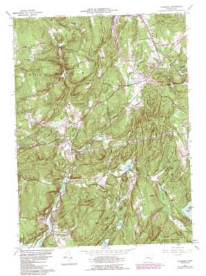
Hamburg Topo Map Connecticut
To zoom in, hover over the map of Hamburg
USGS Topo Quad 41072d3 - 1:24,000 scale
| Topo Map Name: | Hamburg |
| USGS Topo Quad ID: | 41072d3 |
| Print Size: | ca. 21 1/4" wide x 27" high |
| Southeast Coordinates: | 41.375° N latitude / 72.25° W longitude |
| Map Center Coordinates: | 41.4375° N latitude / 72.3125° W longitude |
| U.S. State: | CT |
| Filename: | o41072d3.jpg |
| Download Map JPG Image: | Hamburg topo map 1:24,000 scale |
| Map Type: | Topographic |
| Topo Series: | 7.5´ |
| Map Scale: | 1:24,000 |
| Source of Map Images: | United States Geological Survey (USGS) |
| Alternate Map Versions: |
Hamburg CT 1952, updated 1959 Download PDF Buy paper map Hamburg CT 1961, updated 1963 Download PDF Buy paper map Hamburg CT 1961, updated 1972 Download PDF Buy paper map Hamburg CT 1961, updated 1985 Download PDF Buy paper map Hamburg CT 1961, updated 1988 Download PDF Buy paper map Hamburg CT 2012 Download PDF Buy paper map Hamburg CT 2015 Download PDF Buy paper map |
1:24,000 Topo Quads surrounding Hamburg
> Back to 41072a1 at 1:100,000 scale
> Back to 41072a1 at 1:250,000 scale
> Back to U.S. Topo Maps home
Hamburg topo map: Gazetteer
Hamburg: Airports
Devils Hopyard Field elevation 31m 101′Fetske Seaplane Base elevation 0m 0′
Hamburg: Bridges
Hamburg Bridge elevation 4m 13′Hamburg: Cliffs
Candlewood Ledge elevation 20m 65′Hamburg: Dams
Dodson Pond Dam elevation 69m 226′E A Whitford Pond Dam elevation 37m 121′
Mitchell Pond Dam elevation 64m 209′
Powers Lake Dam elevation 48m 157′
Shingle Mill Pond Dam elevation 96m 314′
Zemko Pond Dam elevation 141m 462′
Hamburg: Falls
Chapman Falls elevation 60m 196′Hamburg: Forests
Nehantic State Forest elevation 84m 275′Hamburg: Lakes
Alexander Pond elevation 89m 291′Blackwells Pond elevation 25m 82′
Cedar Lake elevation 34m 111′
Ed Bills Pond elevation 23m 75′
Horse Pond elevation 133m 436′
Mitchell Pond elevation 64m 209′
Moulsons Pond elevation 11m 36′
Norwich Pond elevation 29m 95′
Shingle Mill Pond elevation 96m 314′
Urbanik Pond elevation 139m 456′
Wagner Pond elevation 34m 111′
Hamburg: Parks
Devils Hopyard State Park elevation 64m 209′Hamburg Bridge Historic District elevation 4m 13′
Hamburg: Populated Places
Crowley Corner elevation 142m 465′Grassy Hill (historical) elevation 108m 354′
Hamburg elevation 8m 26′
Jewitt Corner elevation 26m 85′
Millington elevation 161m 528′
North Lyme elevation 14m 45′
Salem elevation 107m 351′
Sterling City elevation 14m 45′
Hamburg: Post Offices
Salem Post Office elevation 80m 262′Hamburg: Reservoirs
Bond Reservoir elevation 108m 354′Dodson Pond elevation 69m 226′
E A Whitford Pond elevation 37m 121′
Powers Lake elevation 48m 157′
Will Cone Pond elevation 134m 439′
Zemko Pond elevation 141m 462′
Hamburg: Ridges
Chapman Ridge elevation 120m 393′Wheatfield Ridge elevation 97m 318′
Hamburg: Streams
Beaver Brook elevation 9m 29′Burnhams Brook elevation 53m 173′
Cedar Pond Brook elevation 18m 59′
Cranberry Meadow Brook elevation 15m 49′
Early Brook elevation 83m 272′
East Branch Eightmile River elevation 14m 45′
Falls Brook elevation 23m 75′
Fraser Brook elevation 80m 262′
Harris Brook elevation 65m 213′
Hedge Brook elevation 34m 111′
Lake Hayward Brook elevation 76m 249′
Malt House Brook elevation 23m 75′
Muddy Brook elevation 76m 249′
Shingle Mill Brook elevation 75m 246′
Strongs Brook elevation 14m 45′
Tisdale Brook elevation 0m 0′
Hamburg: Summits
Brown Hill elevation 112m 367′Cedar Hill elevation 68m 223′
Dolbia Hill elevation 134m 439′
Grassy Hill elevation 129m 423′
Honey Hill elevation 114m 374′
Mount Archer elevation 136m 446′
Nickerson Hill elevation 123m 403′
Tater Hill elevation 179m 587′
Tiffany Hill elevation 61m 200′
Hamburg digital topo map on disk
Buy this Hamburg topo map showing relief, roads, GPS coordinates and other geographical features, as a high-resolution digital map file on DVD:
New York, Vermont, Connecticut & Western Massachusetts
Buy digital topo maps: New York, Vermont, Connecticut & Western Massachusetts


