Payne Topo Map Ohio
To zoom in, hover over the map of Payne
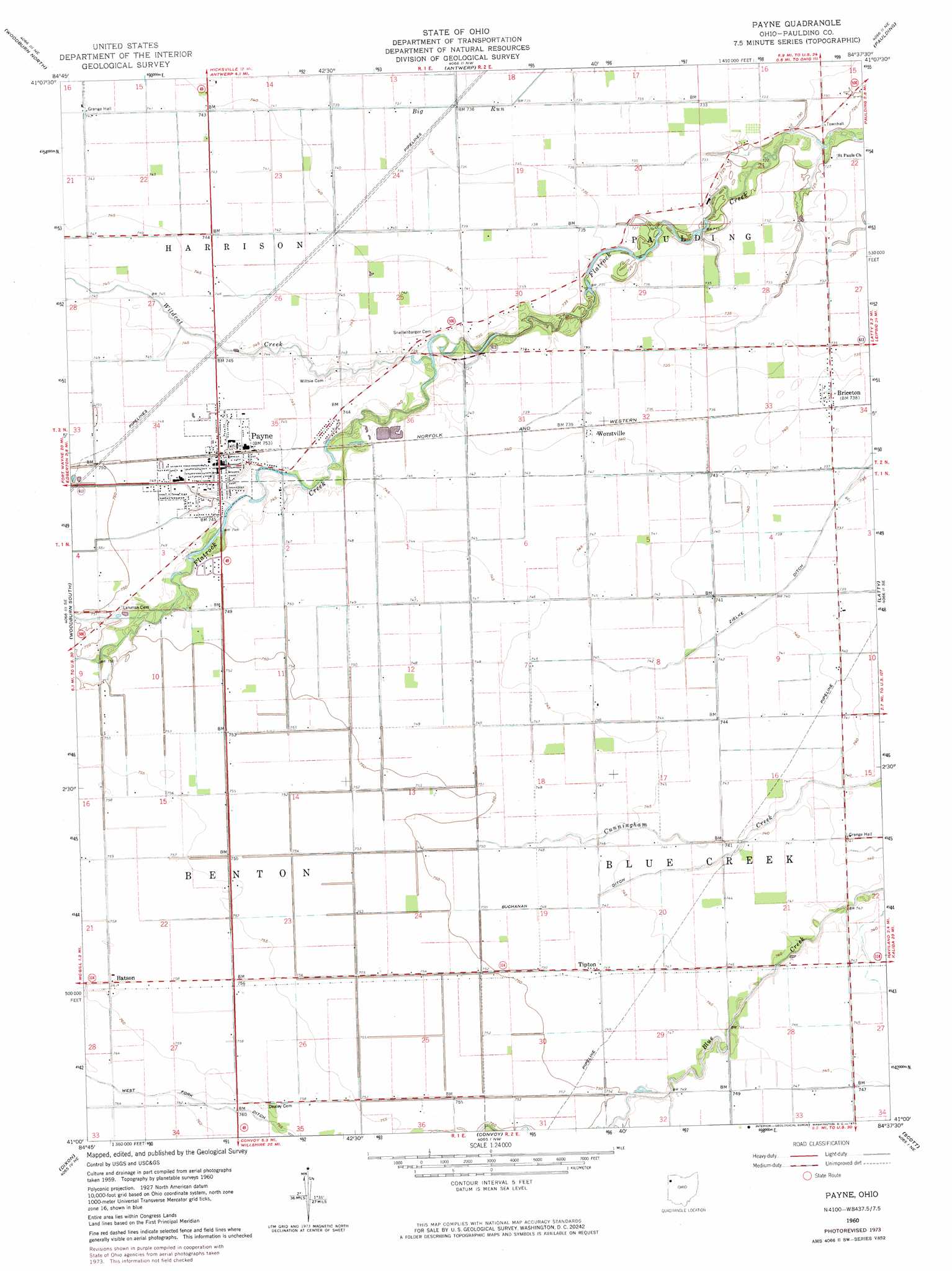
USGS Topo Quad 41084a6 - 1:24,000 scale
| Topo Map Name: | Payne |
| USGS Topo Quad ID: | 41084a6 |
| Print Size: | ca. 21 1/4" wide x 27" high |
| Southeast Coordinates: | 41° N latitude / 84.625° W longitude |
| Map Center Coordinates: | 41.0625° N latitude / 84.6875° W longitude |
| U.S. State: | OH |
| Filename: | o41084a6.jpg |
| Download Map JPG Image: | Payne topo map 1:24,000 scale |
| Map Type: | Topographic |
| Topo Series: | 7.5´ |
| Map Scale: | 1:24,000 |
| Source of Map Images: | United States Geological Survey (USGS) |
| Alternate Map Versions: |
Payne OH 1960, updated 1961 Download PDF Buy paper map Payne OH 1960, updated 1974 Download PDF Buy paper map Payne OH 2010 Download PDF Buy paper map Payne OH 2013 Download PDF Buy paper map Payne OH 2016 Download PDF Buy paper map |
1:24,000 Topo Quads surrounding Payne
Saint Joe |
Hicksville |
Mark Center |
Sherwood |
Defiance West |
Grabill |
Woodburn North |
Antwerp |
Paulding |
Junction |
Maples |
Woodburn South |
Payne |
Latty |
Oakwood |
Hoagland |
Dixon |
Convoy |
Scott |
Wetsel |
Decatur |
Wren |
Glenmore |
Van Wert |
Middle Point |
> Back to 41084a1 at 1:100,000 scale
> Back to 41084a1 at 1:250,000 scale
> Back to U.S. Topo Maps home
Payne topo map: Gazetteer
Payne: Canals
Buchanan Ditch elevation 227m 744′South Fork elevation 231m 757′
Payne: Parks
Payne Community Park elevation 227m 744′School Park elevation 227m 744′
Payne: Populated Places
Batson elevation 231m 757′Briceton elevation 225m 738′
Logtown elevation 231m 757′
Mooney Meadows Subdivision elevation 227m 744′
Payne elevation 227m 744′
Riverview Park Subdivision elevation 224m 734′
Sophia (historical) elevation 229m 751′
Tipton elevation 227m 744′
Worstville elevation 225m 738′
Payne: Post Offices
Batson Post Office (historical) elevation 231m 757′Briceton Post Office (historical) elevation 225m 738′
Payne Post Office elevation 228m 748′
Sophia Post Office (historical) elevation 229m 751′
Tipton Post Office (historical) elevation 227m 744′
WorstvillePost Office (historical) elevation 225m 738′
Payne: Streams
Wildcat Creek elevation 222m 728′Payne digital topo map on disk
Buy this Payne topo map showing relief, roads, GPS coordinates and other geographical features, as a high-resolution digital map file on DVD:
Northern Illinois, Northern Indiana & Southwestern Michigan
Buy digital topo maps: Northern Illinois, Northern Indiana & Southwestern Michigan