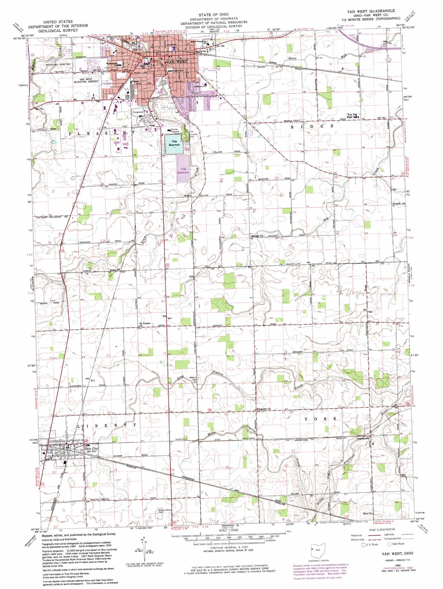
Van Wert Topo Map Ohio
To zoom in, hover over the map of Van Wert
USGS Topo Quad 40084g5 - 1:24,000 scale
| Topo Map Name: | Van Wert |
| USGS Topo Quad ID: | 40084g5 |
| Print Size: | ca. 21 1/4" wide x 27" high |
| Southeast Coordinates: | 40.75° N latitude / 84.5° W longitude |
| Map Center Coordinates: | 40.8125° N latitude / 84.5625° W longitude |
| U.S. State: | OH |
| Filename: | o40084g5.jpg |
| Download Map JPG Image: | Van Wert topo map 1:24,000 scale |
| Map Type: | Topographic |
| Topo Series: | 7.5´ |
| Map Scale: | 1:24,000 |
| Source of Map Images: | United States Geological Survey (USGS) |
| Alternate Map Versions: |
Van Wert OH 1960, updated 1961 Download PDF Buy paper map Van Wert OH 1960, updated 1972 Download PDF Buy paper map Van Wert OH 1960, updated 1983 Download PDF Buy paper map Van Wert OH 2010 Download PDF Buy paper map Van Wert OH 2013 Download PDF Buy paper map Van Wert OH 2016 Download PDF Buy paper map |
1:24,000 Topo Quads surrounding Van Wert
Woodburn South |
Payne |
Latty |
Oakwood |
Continental |
Dixon |
Convoy |
Scott |
Wetsel |
Ottoville |
Wren |
Glenmore |
Van Wert |
Middle Point |
Delphos |
Willshire |
Rockford |
Mendon |
Elgin |
Spencerville |
New Corydon |
Erastus |
Celina |
Saint Marys |
Moulton |
> Back to 40084e1 at 1:100,000 scale
> Back to 40084a1 at 1:250,000 scale
> Back to U.S. Topo Maps home
Van Wert topo map: Gazetteer
Van Wert: Airports
Van Wert County Airport elevation 239m 784′Van Wert: Canals
Baxter Ditch elevation 239m 784′Kiser Ditch elevation 245m 803′
Van Wert: Dams
Van Wert Reservoir Number One Dam elevation 241m 790′Van Wert Reservoir Number Two Dam elevation 240m 787′
Van Wert: Parks
Dickinson Park elevation 239m 784′Fountain Park elevation 234m 767′
Hiestand Park elevation 240m 787′
Memorial Park elevation 238m 780′
Smiley Park elevation 238m 780′
Van Wert: Populated Places
Buena Vista (historical) elevation 247m 810′Jonestown elevation 243m 797′
MacAdam (historical) elevation 247m 810′
Ohio City elevation 250m 820′
Shasta (historical) elevation 246m 807′
Van Wert elevation 237m 777′
Van Wert: Post Offices
Buena Post Office (historical) elevation 247m 810′Ohio City Post Office elevation 250m 820′
Shasta Post Office (historical) elevation 246m 807′
Van Wert Post Office elevation 238m 780′
Van Wert: Reservoirs
City Reservoir elevation 239m 784′Van Wert Reservoir Number One elevation 241m 790′
Van Wert Reservoir Number Two elevation 240m 787′
Van Wert: Streams
Long Prairie Creek elevation 239m 784′Mown Prairie Creek elevation 241m 790′
Van Wert digital topo map on disk
Buy this Van Wert topo map showing relief, roads, GPS coordinates and other geographical features, as a high-resolution digital map file on DVD:
Northern Illinois, Northern Indiana & Southwestern Michigan
Buy digital topo maps: Northern Illinois, Northern Indiana & Southwestern Michigan